 03-26-2023, 11:33 PM
|
#631
|
|
Member
|
|
Join Date: Sep 2015
Location: Montreal, Canada
Posts: 915
Real Name: Jean
|
|
|
Member
Join Date: Sep 2015
Location: Montreal, Canada
Posts: 915
Real Name: Jean
|
Day 43:
Start point: Page AZ
End point: Page AZ
Distance driven: 215 km
Distance hiked: 3.5 km
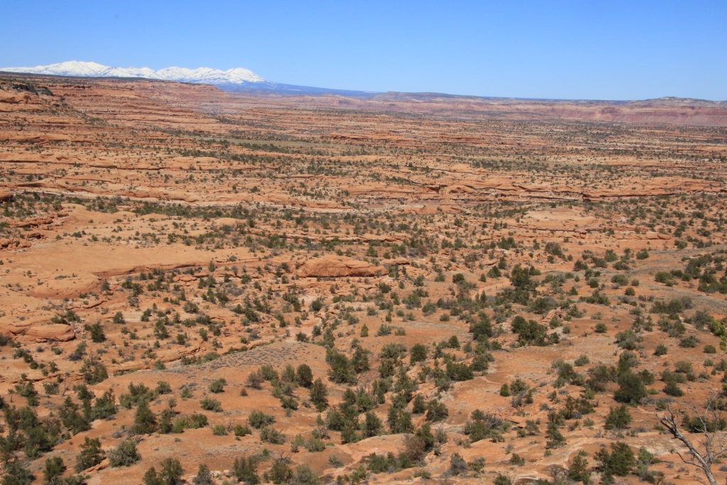
We started the day by heading down Cottonwood Canyon Road located in Grand Staircase-Escalante National Monument. Some portions of this road are assumed to still be impassable. We wanted to see the state for ourselves because it leads to several hikes that we wanted to do.
Funny fact; on this road, we passed a car stuck in deep ruts. Someone was helping him out. The rear wheels did not turn; he didn't know he was driving with the emergency brake on!!!
This road follows the folds of the earth's crust that we walked along yesterday during a hike. It's one of the most spectacular roads in Utah, in my opinion. The arrangement of colors and the turbulent geological past make it a very special place.


In the distance we could also see Yellow Rock, a place we hiked in March 2013.

We reached the Hackberry Canyon Trailhead point before returning, not because it was impassable, but because we had other activities planned. On the way back, we met a group of Longhorns.

Our next activity, still on Cottonwood Canyon Road, was the short hike to Hoodoos Forest, recommended by a very nice tourist we met yesterday. After about a kilometer of walking on the plateau, we reached the stop of this one. At this location, multiple whitish hoodoos were visible. Our tourist had advised us that the descent to the hoodoos was difficult. We decided not to attempt it because it was not only difficult, but downright dangerous. We opted instead to walk along the edge of the cliff.


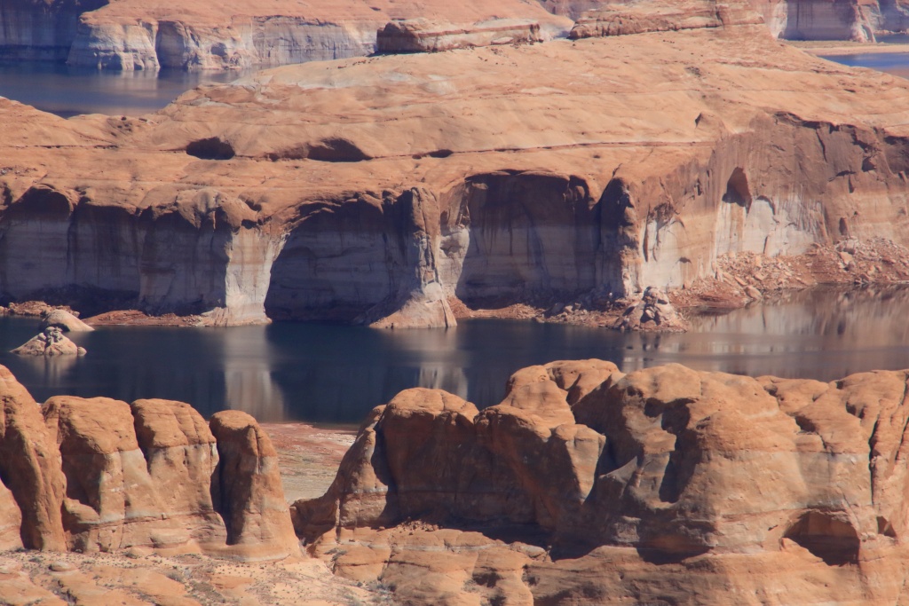
Returning to our vehicle, we headed to Glen Canyon National Recreation Area. Luckily, the very low rainfall of the last few days, but also the sun and the winds have greatly improved Smoky Mountain Road leading to Crosby Canyon, our next destination. This canyon is very beautiful, and very similar to Wiregrass Canyon Trail which we hiked in March 2020, the last activity before our forced return caused by the pandemic.
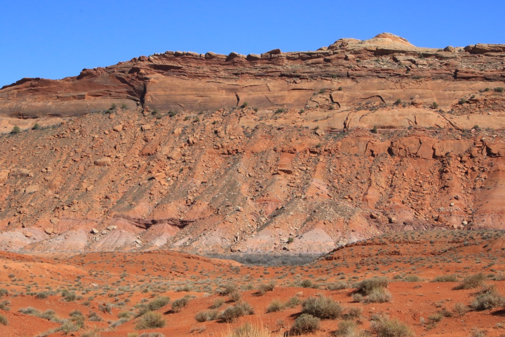
The road gradually descends to Lake Powell but also to the lower geological layers. At the beginning, a layer of coal of a few meters thick is visible.

Then the road joins the whitish layer of hoodoo rocks.

Further down, a greenish layer has appeared.
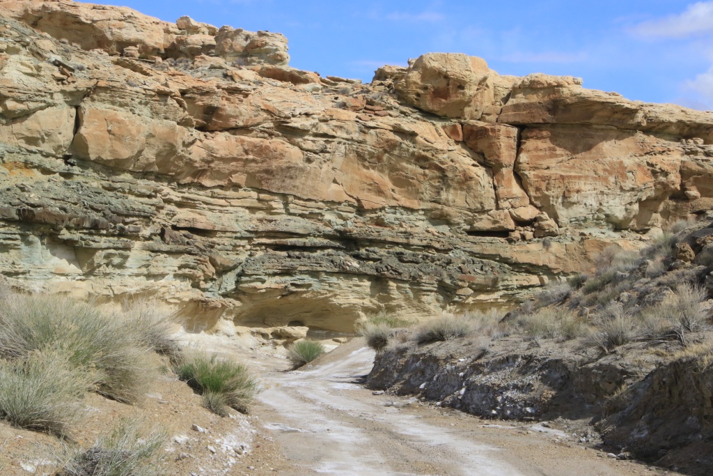
Even lower, the road intersects with a harder layer of rock, forming large recesses under which the road travels.

Finally, we reached the mouth of Crosby Canyon, where the water of Lake Powell was located a few years ago. Instead, we reached a large plain where tamarisks once grew, dead from lack of water. We saw the water in the distance, but without getting really close. Witnesses of a bygone era, many seashells were visible on the sandy ground.

On the other hand, the presence of multiple large clouds encouraged us to start our return in a somewhat hasty way because we were still quite far on the roads on the famous bentonite. Precisely, one of these clouds left us with a little aftertaste of winter that we have been desperately trying to escape since the start of the trip... Fortunately, we only brushed past it without consequence.

Tomorrow, the weather conditions seem to become much more favorable than today. We should try to go further on Smoky Mountain Road. Crossed fingers...
__________________
 2016 Trail Edition Classic Silver Metallic with KDSS, sunroof
ToyTec BOSS lift, SPC Light Racing UCA, RCI sliders, RCI aluminum full skids, RCI Cat Guard, Eezi-Awn K9 2.2m, BFG KO2 275/70R17E, FN Wheels f(X) Pro, ARB Breather kit, Husky WeatherBeater Mat and Cargo, XPEL window tint, 3M wrapped hood
Build thread
Adventures thread
|

|
 Reply With Quote Reply With Quote
|
|
03-27-2023, 06:49 PM
|
#632
|
 |
Senior Member
|
|
Join Date: Jan 2019
Location: AZ
Posts: 1,385
|
|
|
Senior Member
Join Date: Jan 2019
Location: AZ
Posts: 1,385
|
Hope you managed something fun! The climb up Croton is very nice.
__________________
2018 TRD OP non-kdss, well armored, well used
(6112s/650lb at 2.25" lift, 8100 rear with Bilstein B12 1.5" springs, Mickey Thompson ATZ P3 LTE 265 70 17, RCI set of front 3/16 skids, Shrockworks step sliders and 3/16 steel gas tank skid, C4Fab rear diff skid, Rockmen rear LCAs, Total Chaos rear LCA bracket skids, Diode Dynamics SS3 white fog lights).
|
|
|
Reply With Quote
|
|
03-27-2023, 11:18 PM
|
#633
|
|
Member
|
|
Join Date: Sep 2015
Location: Montreal, Canada
Posts: 915
Real Name: Jean
|
|
|
Member
Join Date: Sep 2015
Location: Montreal, Canada
Posts: 915
Real Name: Jean
|
Quote:
Originally Posted by MAST4R

Hope you managed something fun! The climb up Croton is very nice.
|
Yep, we had something fun, but again, not what we planned. May I say I hate wet bentonite clay... Again. See following post.
__________________
2016 Trail Edition Classic Silver Metallic with KDSS, sunroof
ToyTec BOSS lift, SPC Light Racing UCA, RCI sliders, RCI aluminum full skids, RCI Cat Guard, Eezi-Awn K9 2.2m, BFG KO2 275/70R17E, FN Wheels f(X) Pro, ARB Breather kit, Husky WeatherBeater Mat and Cargo, XPEL window tint, 3M wrapped hood
Build thread
Adventures thread
|
|
|
Reply With Quote
|
|
03-28-2023, 12:53 AM
|
#634
|
|
Member
|
|
Join Date: Sep 2015
Location: Montreal, Canada
Posts: 915
Real Name: Jean
|
|
|
Member
Join Date: Sep 2015
Location: Montreal, Canada
Posts: 915
Real Name: Jean
|
Day 44:
Start point: Page AZ
End point: Page AZ
Distance driven: 238 km
Distance hiked: 1.1 km
We had a superb day, without any cloud, enough to cheer us up a bit. We took the opportunity to drive a few roads in the splendid region of Glen Canyon National Recreation Area. However, we had to deal once again with some impassable segments. This changed our original itinerary somewhat and led us back to some familiar places. Expect a photo fest in this post!
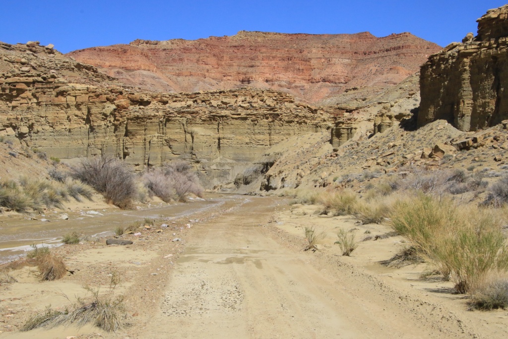
We took the Smoky Mountain Road again, then turned onto Sitdown Bench Road. This road skirts very colorful hills, formed of bentonite clay. The road itself mostly runs on this lovely bentonite. The beautiful temperature of the last few days had dried up the clay, leaving immaculate white salt deposits, but also deep ruts from vehicles having circulated while it was still wet.


As we progressed, the state of the road deteriorated, becoming gradually wetter. The inevitable happened when we joined a very long section of road still flooded, partially frozen, and frankly impassable. It was with great disappointment that we turned around. We had long dreamed of the wonders further up the road. That will be for another time.

On the way back, the sun highlighted the beautiful colors of the hills.

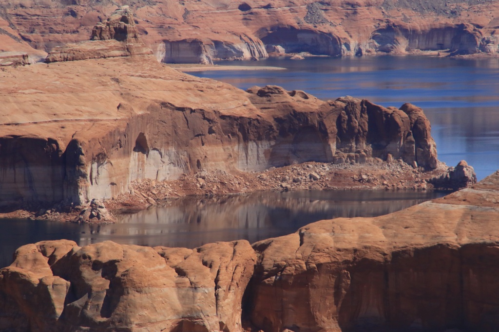
We then decided to return to Alstrom Point, a promontory located on a long point overlooking Lake Powell. Well, this was when the water level was sufficient to reach the foot of the high cliffs.
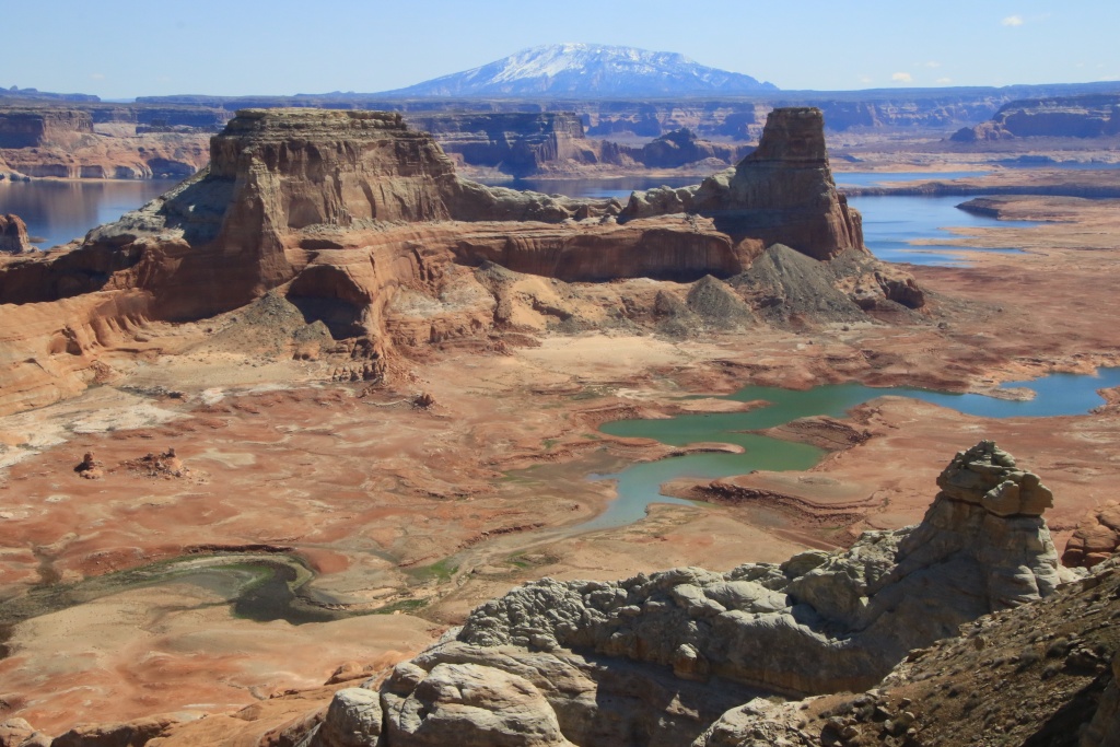
At this location, we met four Californians, owners of heavily modified 4Runners, who were camping there for a few days. I took the opportunity to chat, collecting ideas for future modifications of our own 4Runner.
Afterwards, we paused at the top of a cliff overlooking a bay adjacent to Alstrom Point. What a beautiful view we had!

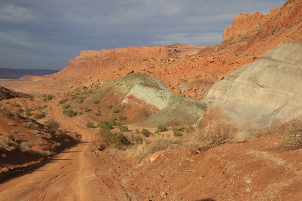
We then headed up Smoky Hollow Road, a road up through the bottom of a canyon to the high plateau of Smoky Mountain. Here again, the cliffs were brilliantly colored.

On several occasions, the road borrows the bed of a creek. As we gained altitude, the water became more present, again. We crossed and skirted this creek on a few occasions, but our progress became more and more hazardous. Yes, yet another U-turn...
Decided to get up to the plateau, we then headed down Smoky Mountain Road which climbs the cliff steeply at a place called Kelly Grade. It's a generally fairly well-maintained road, but somewhat intimidating considering the cliffs it skirts. Yes, there is a road that climbs the cliff in the following photo!

At the top of the first section, the road intersects a coal seam.

The road then continues its ascent, but in a much more gradual way, always skirting the cliff and making long loops.

Finally at the top, we stopped at a viewpoint toward the road we had just traveled, with Crosby Canyon visible above the ridge of the cliff.

And on the opposite direction, the plain of the high plateau covered with bushes and far away, the mountains near Escalante UT. What a contrast! We had hoped to travel this road from Escalante to reach Kanab more than two weeks ago, but the presence of snow made driving impossible. Another time maybe.

After some distance we took a side track to two viewpoints over Burning Hills Wilderness Study Area.

We also explored a few other opportunities for an upcoming trip before embarking on our return. On the way back down Kelly Grade, we made a few stops to take in the scenery. Below, a hoodoo with a funny hat cast its shadow, stretched out under the lowering sun.

Although we didn't manage to see and do what we had planned, we had a great day nonetheless.
__________________
2016 Trail Edition Classic Silver Metallic with KDSS, sunroof
ToyTec BOSS lift, SPC Light Racing UCA, RCI sliders, RCI aluminum full skids, RCI Cat Guard, Eezi-Awn K9 2.2m, BFG KO2 275/70R17E, FN Wheels f(X) Pro, ARB Breather kit, Husky WeatherBeater Mat and Cargo, XPEL window tint, 3M wrapped hood
Build thread
Adventures thread
|
|
|
Reply With Quote
|
|
03-28-2023, 11:02 PM
|
#635
|
|
Member
|
|
Join Date: Sep 2015
Location: Montreal, Canada
Posts: 915
Real Name: Jean
|
|
|
Member
Join Date: Sep 2015
Location: Montreal, Canada
Posts: 915
Real Name: Jean
|
Day 45:
Starting point: Page AZ
End point: Kayenta AZ
Distance driven: 338 km
We had another great day, as an early morning haze lifted, giving way to beautiful blue skies. We left Page to reach Kayenta AZ, about an hour and a half away. However, we preferred to do a long loop on main roads in Navajo territory instead.
We left the AZ98 road, the Among the People Scenic Byway, to take the Navajo BIA-16 road, a paved road that joins the community of Navajo Mountain, located in Utah. This route could certainly be designated as a scenic route by the Navajo government. Unfortunately, it is very winding and offers very few parking opportunities. Navajo Mountain, a sacred mountain to the Navajo, still wearing its winter coat.

We had some doubts about the legality of our presence on these roads. The Navajo Nation website indicates that the presence of a Navajo guide is required to accompany non-residents. On the other hand, we spoke with all the drivers of the vehicles we met and all confirmed that there was no problem for us to travel on these roads. We sometimes have a reflex of apprehension towards the Amerindians, but all the Navajo with whom we exchanged were extremely courteous and friendly.
Back at Navajo Mountain, we continued on Piute Creek Road, a spectacular drive down to the bottom of Piute Creek Canyon, before climbing back up Piute Mesa on the other side.


Towards the bottom of the descent, we took a short side trip down Piute Canyon Road, a road descending along Piute Canyon leading to the San Juan River. The road deteriorates rapidly and becomes a track of off-road vehicles smaller than our 4Runner. Luckily we could see the river in the distance.


Back on Piute Creek Road, we completed the descent and crossed the bridge over Piute Creek.

We then began the ascent to Piute Mesa, offering an exceptional view of the descent we had just completed.


Once the rocky ascent on Piute Mesa was completed, we made a second side trip by taking, you guessed it, Piute Mesa Road (these Navajos have consistent ideas!). This road leads to two viewpoints of Nokai Canyon and the San Juan River in the distance.

On the other side of the canyon, No Mans Mesa occupied the horizon. We imagine that no road exists to reach the summit, hence the name.

Back on Piute Mesa Road, we began our return south. The road slowly continues its ascent to Tall Mountain and offers some opportunities to see Navajo Mountain again.

The road surface is mostly made up of well-compacted sand, providing a very pleasant ride. Vigilance is required because several rocks are outcropping. In several places, we had to cross wet or muddy areas, caused by the melting of the residual snow.

We sometimes had some doubts about having to turn around because we had contradictory information on the state of the road between the different drivers we questioned. We finally made it to Shonto AZ and completed the planned loop without major hitches.
Tomorrow, we will stay around Kayenta to continue our exploration of this new region for us. Although very close to Monument Valley Tribal Park, we won't be returning there as we've visited it many times before.
__________________
2016 Trail Edition Classic Silver Metallic with KDSS, sunroof
ToyTec BOSS lift, SPC Light Racing UCA, RCI sliders, RCI aluminum full skids, RCI Cat Guard, Eezi-Awn K9 2.2m, BFG KO2 275/70R17E, FN Wheels f(X) Pro, ARB Breather kit, Husky WeatherBeater Mat and Cargo, XPEL window tint, 3M wrapped hood
Build thread
Adventures thread
|
|
|
Reply With Quote
|
|
03-29-2023, 11:36 PM
|
#636
|
|
Member
|
|
Join Date: Sep 2015
Location: Montreal, Canada
Posts: 915
Real Name: Jean
|
|
|
Member
Join Date: Sep 2015
Location: Montreal, Canada
Posts: 915
Real Name: Jean
|
Day 46:
Start point: Kayenta AZ
End point: Kayenta AZ
Distance driven: 361 km
We spent the day exploring Navajo territory around Kayenta AZ, being careful to stay on the main roads. The morning sun left us around the middle of the day. We traveled three roads revealing beautiful attractions.
We started by driving BIA-6460 through Cane Valley and skirting the Comb Ridge Earth's Crust Fold. We saw several features of volcanic origin, including old volcanic cores like Agathia Peak on the right of the next photo, as well as several dykes.


We had planned to take a short hike near Comb Ridge, but being in Navajo Reservation and seeing the presence of residences nearby, we were uncomfortable being on private land. Out of respect for the residents, we have decided to let it be.
Back on the US160 road, we passed a site called Baby Rocks, similar to Goblin Valley SP in Utah, but much less extensive.

Then we headed down Piute Farms Road, a road that runs along No Mans Mesa seen yesterday and reaches the San Juan River.

We reached a large floodplain now dry considering the water level of Lake Powell.

When we arrived on the bank, what was our astonishment to see a waterfall of several meters with a fairly high water flow. Utah Wildlife Service researchers were working taking samples.


After returning to the paved road, we headed for BIA-6450 then BIA-6420 circulating in the bottom of a canyon bordered by high sandstone cliffs.

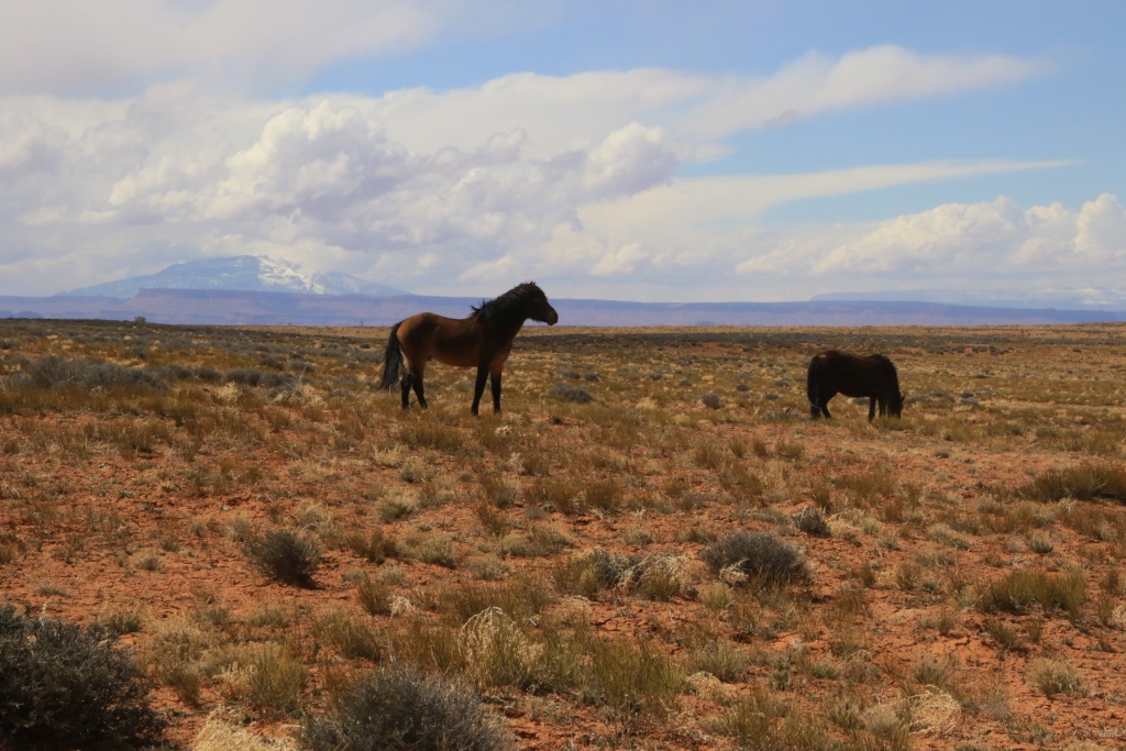
As in several other places in Navajo territory, we saw several groups of horses on the loose.


At a certain point, the road leaves the wash at the bottom of the canyon to go up on top of a plateau, crossing pretty bentonite hills, fortunately well lit during our passage.
Du for lack of time, we turned around long before reaching the destination point we had set ourselves.
Tomorrow, we will leave Kayenta to reach Mexican Hat in Utah for a few days.
__________________
2016 Trail Edition Classic Silver Metallic with KDSS, sunroof
ToyTec BOSS lift, SPC Light Racing UCA, RCI sliders, RCI aluminum full skids, RCI Cat Guard, Eezi-Awn K9 2.2m, BFG KO2 275/70R17E, FN Wheels f(X) Pro, ARB Breather kit, Husky WeatherBeater Mat and Cargo, XPEL window tint, 3M wrapped hood
Build thread
Adventures thread
|
|
|
Reply With Quote
|
|
03-30-2023, 11:22 PM
|
#637
|
|
Member
|
|
Join Date: Sep 2015
Location: Montreal, Canada
Posts: 915
Real Name: Jean
|
|
|
Member
Join Date: Sep 2015
Location: Montreal, Canada
Posts: 915
Real Name: Jean
|
Day 47:
Start point: Kayenta AZ
End point: Mexican Hat UT
Distance driven: 212 km
We had a two-tone day, as our planned activities were disrupted by a major weather system that swept through the region, bringing with it very strong winds, snow, and rain. As our first planned destination was in the mountains, we encountered snow en route and wisely turned back as we wouldn't have been able to see anything anyway.
We instead drove to Monument Valley and waited in the parking lot for the precipitation to stop and the sky to clear, as the system was not expected to impact us for very long. After about an hour we could start seeing West Mitten Butte again.

About another half hour later, the sky quickly cleared. What a contrast! We then decided to once again take the Scenic Drive winding near the park's mounds.


Then we headed to Douglas Mesa Road, located in Navajo territory. Unlike the other regions outside the reserve where we very often encountered cows, here we encountered horses, donkeys, and mules roaming free, with Navajo Mountain in the distance. Concept!
The road gradually gains elevation as it progresses across the plateau. Monument Valley was visible in the distance, as well as Raplee Ridge towards Mexican Hat, another fold of the earth's crust that we will visit in the next few days.


Douglas Mesa Road joins several side trails along the cliffs above the San Juan River below at the bottom of the canyon.


We then reached Mexican Hat where we will spend the next four nights. After connecting to the Internet at our hotel, we saw a message from a good old friend who was also traveling in Utah. We will have the great pleasure of seeing him and his wife again after too many years without contact. See you tomorrow Alain and Francine!
__________________
2016 Trail Edition Classic Silver Metallic with KDSS, sunroof
ToyTec BOSS lift, SPC Light Racing UCA, RCI sliders, RCI aluminum full skids, RCI Cat Guard, Eezi-Awn K9 2.2m, BFG KO2 275/70R17E, FN Wheels f(X) Pro, ARB Breather kit, Husky WeatherBeater Mat and Cargo, XPEL window tint, 3M wrapped hood
Build thread
Adventures thread
|
|
|
Reply With Quote
|
|
03-31-2023, 11:05 PM
|
#638
|
|
Senior Member
|
|
Join Date: Jan 2019
Location: AZ
Posts: 1,385
|
|
|
Senior Member
Join Date: Jan 2019
Location: AZ
Posts: 1,385
|
More great pics, thanks for sharing! My understanding is that all dirt roads on the reservation require a permit. Piute Creek Road sure looks good.
__________________
2018 TRD OP non-kdss, well armored, well used
(6112s/650lb at 2.25" lift, 8100 rear with Bilstein B12 1.5" springs, Mickey Thompson ATZ P3 LTE 265 70 17, RCI set of front 3/16 skids, Shrockworks step sliders and 3/16 steel gas tank skid, C4Fab rear diff skid, Rockmen rear LCAs, Total Chaos rear LCA bracket skids, Diode Dynamics SS3 white fog lights).
|
|
|
Reply With Quote
|
|
03-31-2023, 11:12 PM
|
#639
|
|
Member
|
|
Join Date: Sep 2015
Location: Montreal, Canada
Posts: 915
Real Name: Jean
|
|
|
Member
Join Date: Sep 2015
Location: Montreal, Canada
Posts: 915
Real Name: Jean
|
Quote:
Originally Posted by MAST4R
More great pics, thanks for sharing! My understanding is that all dirt roads on the reservation require a permit. Piute Creek Road sure looks good.
|
Thanks!
Since many or the main roads are dirt roads, I doubt a permit is required for those. But for more remote or secondary, That might be the case.
On our way in, we stopped at Window Rock to get this clarification. Unfortunately, all offices were closed so we didn't get any clear answers. We did respect the privacy of residents, and we didn't hike at some places we felt was not appropriate. Next time, I will try to get this answer to be sure.
__________________
2016 Trail Edition Classic Silver Metallic with KDSS, sunroof
ToyTec BOSS lift, SPC Light Racing UCA, RCI sliders, RCI aluminum full skids, RCI Cat Guard, Eezi-Awn K9 2.2m, BFG KO2 275/70R17E, FN Wheels f(X) Pro, ARB Breather kit, Husky WeatherBeater Mat and Cargo, XPEL window tint, 3M wrapped hood
Build thread
Adventures thread
|
|
|
Reply With Quote
|
|
04-01-2023, 12:18 AM
|
#640
|
|
Member
|
|
Join Date: Sep 2015
Location: Montreal, Canada
Posts: 915
Real Name: Jean
|
|
|
Member
Join Date: Sep 2015
Location: Montreal, Canada
Posts: 915
Real Name: Jean
|
Day 48:
Start point: Mexican Hat UT
End point: Mexican Hat UT
Distance driven: 116 km
Distance hiked: km
We had a wonderful day in very good company with Alain and Francine, friends from the Montreal area. Thanks to our blog, they were able to follow us and see that our routes intersected in Mexican Hat. What a great surprise we had!
After a bit of catching up on the long years of not seeing each other, we decided to hike off trail to a headland on Comb Ridge, tower near Bluff UT. The view was magnificent, despite the strong wind.


We are still waiting for flowers to bloom, although we have seen some.

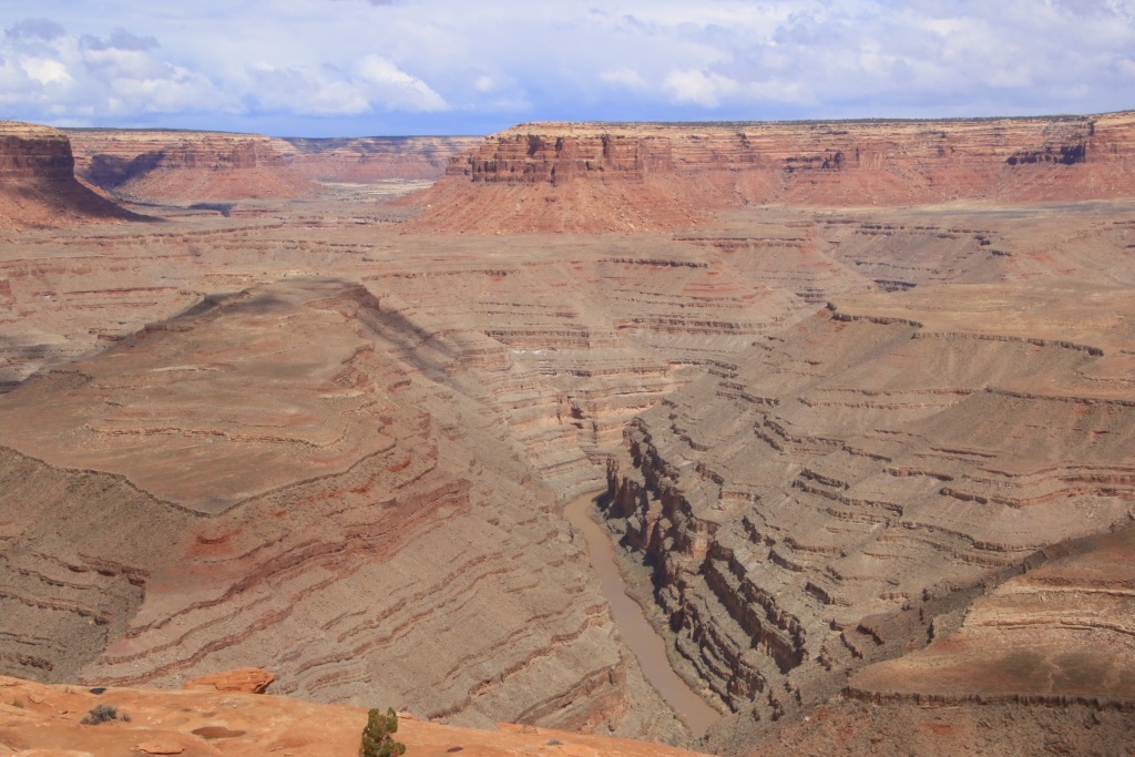
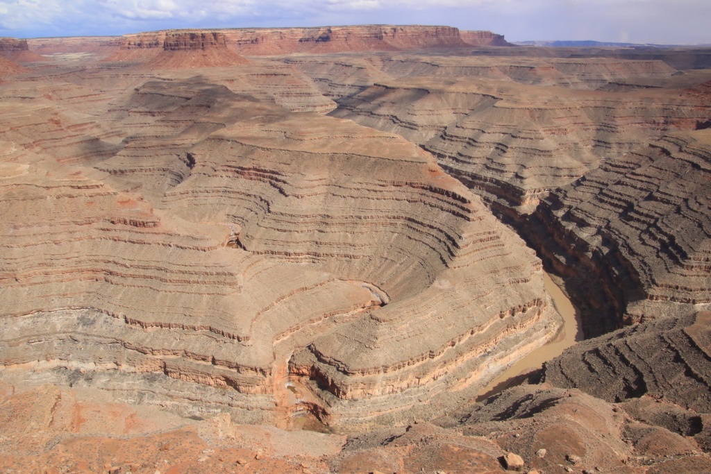
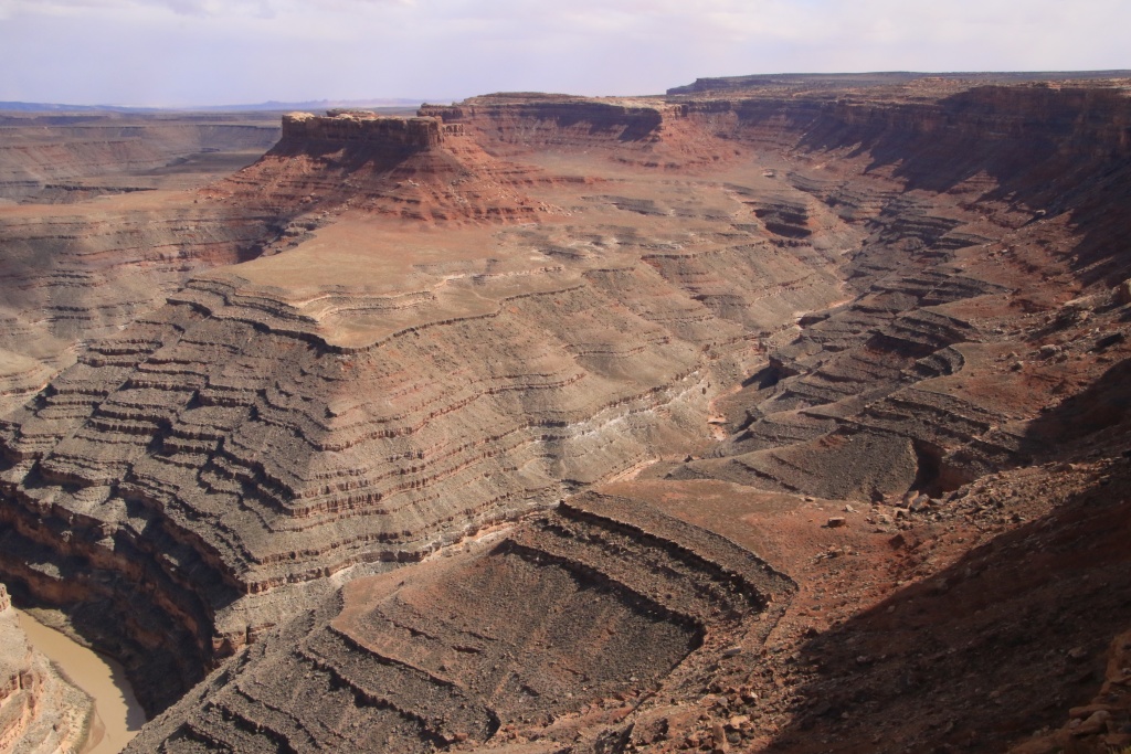
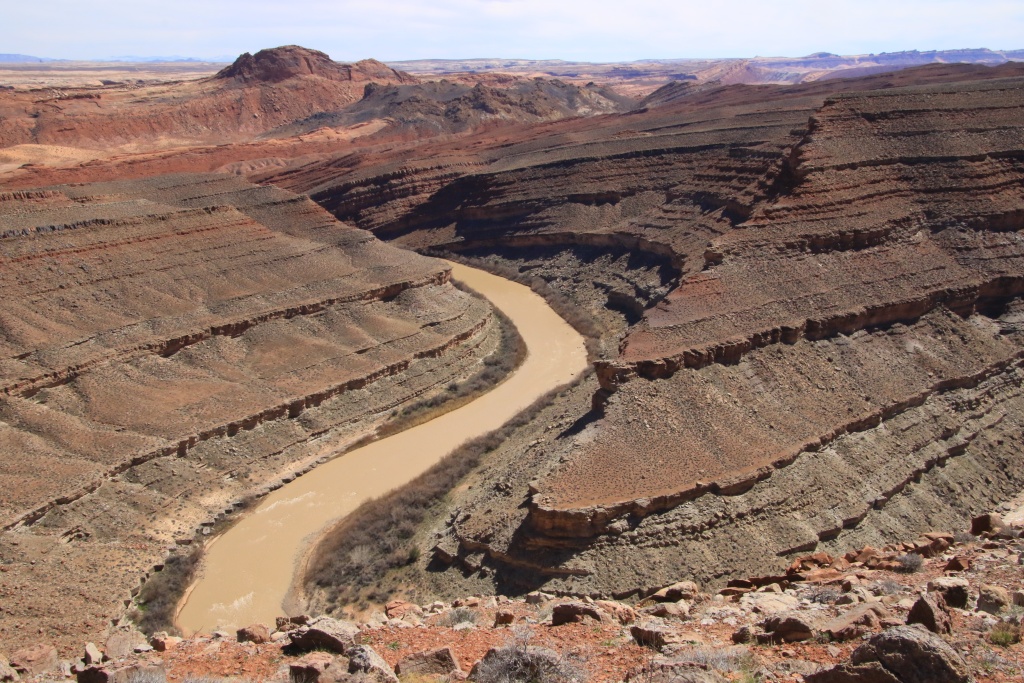
After returning to our vehicles, we acted as guides for Alain and Francine to show them some attractions in the region, such as Gooseneck State Park near Mexican Hat. At this point, the San Juan River makes three long meanders at the bottom of a deep gorge, thus traveling 10 km to advance only 2.5 km.

Then we climbed the long slope of Moki Dugway, gaining over 300 meters in elevation. From the top, the view is superb, allowing to see Valley of the Gods below, with Raplee Ridge in the distance, place which we will explore during our stay in Mexican Hat.


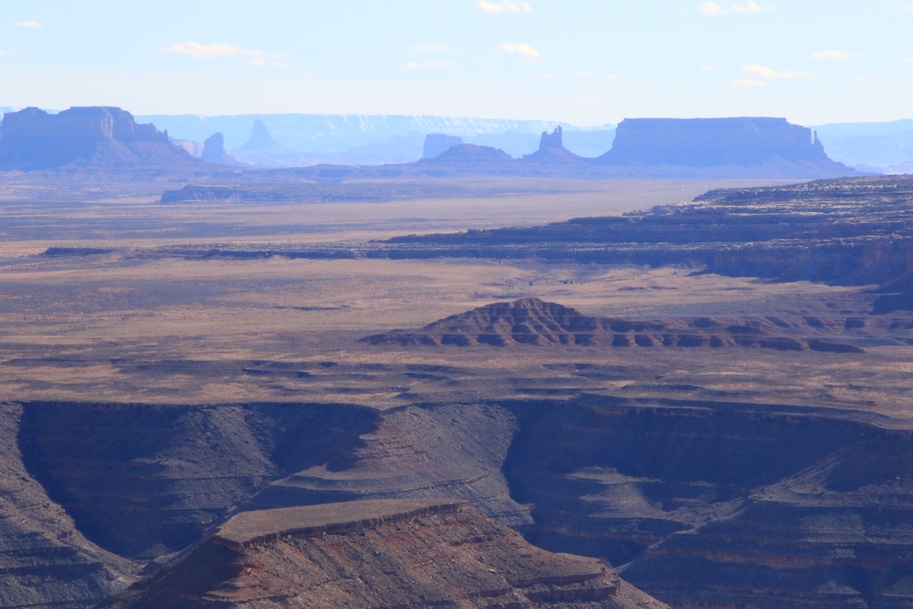
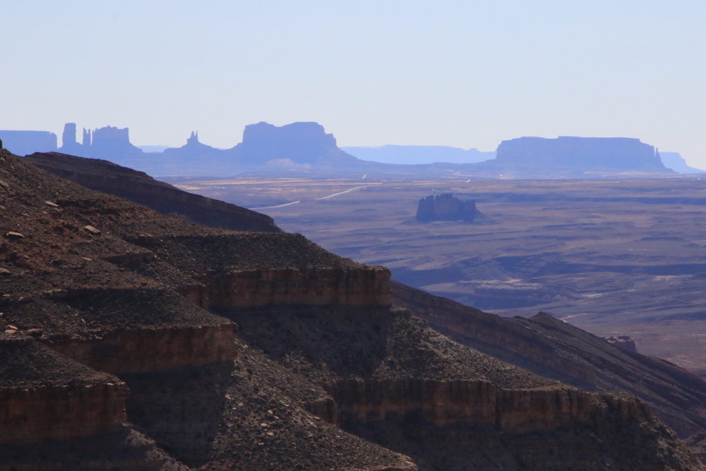
We continued and joined Muley Point in Glen Canyon National Recreation Area, offering several viewpoints along this point. We could see the buttes of Monument Valley, as well as in the distance Agathia Peak near Kayenta AZ.
Coming back to Mexican Hat, at the intersection of UT 261 and US163, the chevron patterns of Raplee Ridge were vibrantly colored. What an exceptional work of Mother Nature!

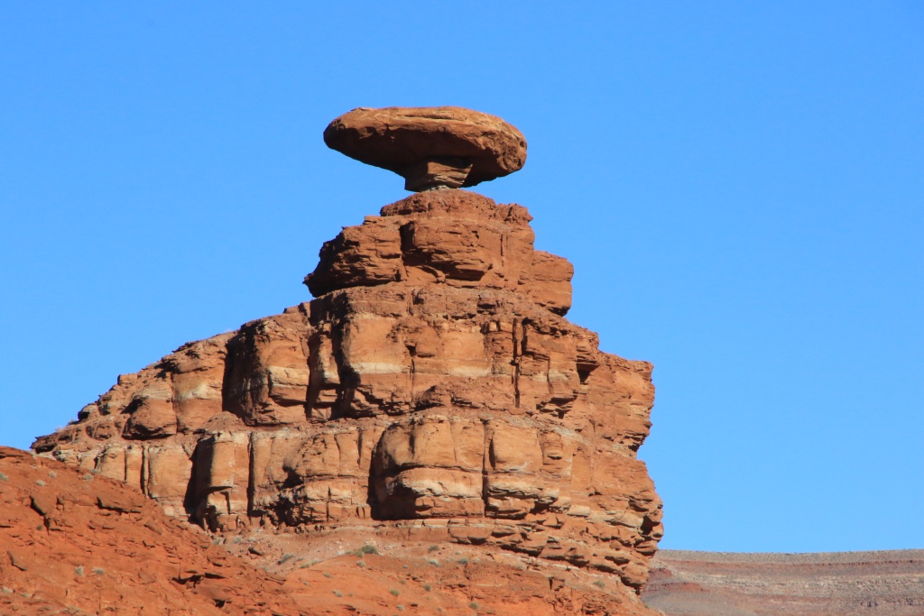
To end the guided tours, we joined the emblem par excellence of Mexican Hat, the hoodoo in the shape of a Mexican hat located near the village.
We then had a very good meal at the Swinging Steak Restaurant, whose name comes from the cooking grill for steaks, swinging like a swing to cook them over the flame without them burning. Original!

We left Alain and Francine, promising to meet again when we returned to Quebec, but also during future trips.
Tomorrow, as the good weather persists, we will take the opportunity to further explore the Mexican Hat region.
__________________
2016 Trail Edition Classic Silver Metallic with KDSS, sunroof
ToyTec BOSS lift, SPC Light Racing UCA, RCI sliders, RCI aluminum full skids, RCI Cat Guard, Eezi-Awn K9 2.2m, BFG KO2 275/70R17E, FN Wheels f(X) Pro, ARB Breather kit, Husky WeatherBeater Mat and Cargo, XPEL window tint, 3M wrapped hood
Build thread
Adventures thread
|
|
|
Reply With Quote
|
|
04-01-2023, 11:25 PM
|
#641
|
|
Senior Member
|
|
Join Date: Jan 2019
Location: AZ
Posts: 1,385
|
|
|
Senior Member
Join Date: Jan 2019
Location: AZ
Posts: 1,385
|
Haha, yeah, I have had a steak there. What does it cost nowadays?
__________________
2018 TRD OP non-kdss, well armored, well used
(6112s/650lb at 2.25" lift, 8100 rear with Bilstein B12 1.5" springs, Mickey Thompson ATZ P3 LTE 265 70 17, RCI set of front 3/16 skids, Shrockworks step sliders and 3/16 steel gas tank skid, C4Fab rear diff skid, Rockmen rear LCAs, Total Chaos rear LCA bracket skids, Diode Dynamics SS3 white fog lights).
|
|
|
Reply With Quote
|
|
04-02-2023, 12:19 AM
|
#642
|
|
Member
|
|
Join Date: Sep 2015
Location: Montreal, Canada
Posts: 915
Real Name: Jean
|
|
|
Member
Join Date: Sep 2015
Location: Montreal, Canada
Posts: 915
Real Name: Jean
|
Quote:
Originally Posted by MAST4R
Haha, yeah, I have had a steak there. What does it cost nowadays?
|
Starting at 28USD... 40CAD... Of course, before taxes and tip.
__________________
2016 Trail Edition Classic Silver Metallic with KDSS, sunroof
ToyTec BOSS lift, SPC Light Racing UCA, RCI sliders, RCI aluminum full skids, RCI Cat Guard, Eezi-Awn K9 2.2m, BFG KO2 275/70R17E, FN Wheels f(X) Pro, ARB Breather kit, Husky WeatherBeater Mat and Cargo, XPEL window tint, 3M wrapped hood
Build thread
Adventures thread
|
|
|
Reply With Quote
|
|
04-02-2023, 12:31 AM
|
#643
|
|
Member
|
|
Join Date: Sep 2015
Location: Montreal, Canada
Posts: 915
Real Name: Jean
|
|
|
Member
Join Date: Sep 2015
Location: Montreal, Canada
Posts: 915
Real Name: Jean
|
Day 49:
Start point: Mexican Hat UT
End point: Mexican Hat UT
Distance driven: 159 km
Distance hiked: 4.5 km
We were once again very thankful for the superb weather and a temperature around 20C, which allowed me to put on my shorts!!! We took full advantage of it to explore some off-road tracks as well as some short hikes to see archaeological sites of Ancestral Puebloans.
Our first destination of the day was the Lower Comb Wash trail in Bears Ears National Monument, leading to several sites of Native American dwelling ruins, as well as several petroglyph panels. The track runs along Comb Wash and crosses it several times. The approaches to the crossings were sometimes very abrupt following the heavy rains of the last weeks having eroded them.

The trail also follows the route of a Mormon expedition to establish a community at what is now Bluff UT. At one point, this task seemed like a miracle when climbing a long, steep incline. The horses were tied one after the other in line, and allowed to help each other when some lost a little grip.

A junction on the track leads to a plateau offering an interesting view towards our next destination.
Back on the main trail we saw River House cliff dwelling ruins. A staircase made it possible to see them more closely while even exploring a few rooms. Impressive construction, and what a beautiful view of the valley.

The ruins are built on a long shelf where some petroglyphs can be seen.

Further along the main track, it approaches the San Juan River and we passed through a tamarisk grove forming a tunnel of almost perfect dimensions for our 4Runner. This one also probably has new memories in the form of pinstripes. Well, more experience...

At the end of the track, we walked along a path along a very long petroglyph mural, the Kachina Panel. The condition of these and their beauty certainly make it one of the finest examples of these rock works. A River Ranger who docked for a stopover with his son briefly explained to us that the petroglyphs were made during different eras, dating between 800 and 4000 years ago.

After returning to our starting point, we headed down Lime Ridge Road, a track on the high plateau lined with herringbone patterns seen yesterday. Although the main track is in fairly good condition, the secondary tracks leading to several viewpoints are much rockier. We had started one of these secondary tracks in October 2016, but since our vehicle had practically no protection against impacts, we had to turn around. Not today!
A side track joined a San Juan River lookout overlooking Lower Comb Wash Road that we had just hiked, but also a place in Navajo territory that we had considered doing a long off-trail hike, but a sign saying no access prompted us to abandon this project.

Further on, the viewpoints are much higher and deep canyons have been carved out by the San Juan River or its tributaries.
Returning to another viewpoint, drifting along the current of the San Juan River, we could see several groups of boats. These seemed a little lost in the immensity of the landscape. These people certainly must not have thought that they were being watched by us from these exceptional vantage points.


Moreover, we had an unusual view from the top of our plateau towards Monument Valley.
Having completed the long loop on Lime Ridge Road, we headed to another off-road track, Lime Creek Road. This joins the base of Raplee Ridge and its herringbone patterns.

Unfortunately, a past flood completely washed away the ground near Lime Creek and made the trail inaccessible past that point.
Tomorrow, we will reach the high plateau of Grand Gulch to explore other off-road tracks, but also a hike to a site of ruins accessible by permit that we were lucky enough to obtain.
__________________
2016 Trail Edition Classic Silver Metallic with KDSS, sunroof
ToyTec BOSS lift, SPC Light Racing UCA, RCI sliders, RCI aluminum full skids, RCI Cat Guard, Eezi-Awn K9 2.2m, BFG KO2 275/70R17E, FN Wheels f(X) Pro, ARB Breather kit, Husky WeatherBeater Mat and Cargo, XPEL window tint, 3M wrapped hood
Build thread
Adventures thread
|
|
|
Reply With Quote
|
|
04-02-2023, 11:06 PM
|
#644
|
|
Member
|
|
Join Date: Sep 2015
Location: Montreal, Canada
Posts: 915
Real Name: Jean
|
|
|
Member
Join Date: Sep 2015
Location: Montreal, Canada
Posts: 915
Real Name: Jean
|
Day 50:
Start point: Mexican Hat UT
End point: Mexican Hat UT
Distance driven: 151 km
Distance hiked: 5.8 km
We had a day in two parts, efforts and strong emotions, then relaxation and contemplation. The emotions came from a pretty daunting hike through a canyon to see ruins of Ancestral Puebloan dwellings. Then, we walked around Mexican Hat to conclude our visits to this area.
To start the day, we went to Kane Gulch Ranger Station in the Grand Gulch area of Bears Ears National Monument to get our permit validated for our hike to Moon House.
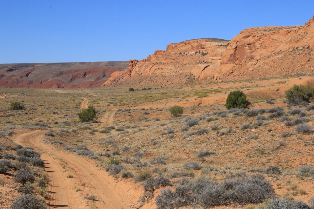
When this administrative step was completed, we took Snow Flat Road. This track was in decent condition at the start, with its share of deep ruts, but at least dry. It crosses a large expanse of short cedars, and some clearings, the flats.
We then took a secondary track to reach the start of the hike to Moon House. Although the trail is marked, it is very intimidating as it skirts the walls of the canyon to reach the bottom, then back up to reach the ruins on the other side, on a plateau in the canyon. Several passages are a bit tricky and very sandy, while others are sloping towards the abyss.

We were the first of twenty visitors admitted daily to Moon House. The arrival of other visitors gave us the opportunity to see the impressive descent from one level to another in the distance. The most difficult part of the hike has two stages. The first is a slope without too many holds to reach a narrow landing (two light bands surrounding a dark one towards which the lowest person is heading). Descent on the buttocks hoping not to go straight. Then, you have to reach the pile of rocks piled up in a way that is too precarious .

The Moon House ruins are in excellent condition, and a few rooms are even allowed to be entered.


The name given to this ruin comes from the drawings representing the phases of the moon painted in two places, including here in one of the rooms.

We then reached other ruins located on the same level as Moon House.

We then hike the opposite way to return to the 4Runner. Although the climbs are usually easier, this one was particularly taxing given the rapid elevation gain compounded by the altitude, and given the difficult passage that proved even more daunting with the lack of holds. Finally, we returned quite exhausted to the vehicle.
Continuing on Snow Flat Road, we took another short hike to Snow Cave, also located in a canyon. However, access is much easier as it is located near plateau level. This large alcove contains two sources of water flowing through the rock formed from sandstone. We saw ruins of basins once installed by cowboys to catch water dripping from the ceiling.


The Snow Flat Road trail follows the Immigrant Trail, a trail built by Mormon pioneers to found Bluff UT. Yesterday we saw a segment of it near the San Juan River. Imagine the difficulties to cross this kind of terrain. They had to suffer and toil.
At its eastern end, Snow Flat Road joins Comb Wash Road, a track we drove last on our March 2016 trip, before returning home following the death of my father. This beautiful trail skirts Comb Ridge for the west.

Having completed Snow Flat Road and Comb Wash Road, we explored around Mexican Hat Rock. A typical Old West scene was these Tumbleweeds, bushes withered and spreading their seeds as they rolled, blown away by the wind. Often they get captured by a fence or a ravine.

Further, the chevron patterns of Raplee Ridge and the San Juan River flowing at its base.

Tomorrow we leave Mexican Hat to join Blanding UT not far, a little closer to the mountains. The weather forecast for tomorrow calls for cooling with strong winds and a low chance of precipitation. We'll let you know tomorrow morning.
__________________
2016 Trail Edition Classic Silver Metallic with KDSS, sunroof
ToyTec BOSS lift, SPC Light Racing UCA, RCI sliders, RCI aluminum full skids, RCI Cat Guard, Eezi-Awn K9 2.2m, BFG KO2 275/70R17E, FN Wheels f(X) Pro, ARB Breather kit, Husky WeatherBeater Mat and Cargo, XPEL window tint, 3M wrapped hood
Build thread
Adventures thread
|
|
|
Reply With Quote
|
|
04-03-2023, 10:51 PM
|
#645
|
|
Member
|
|
Join Date: Sep 2015
Location: Montreal, Canada
Posts: 915
Real Name: Jean
|
|
|
Member
Join Date: Sep 2015
Location: Montreal, Canada
Posts: 915
Real Name: Jean
|
Day 51:
Start point: Mexican Hat UT
End point: Blanding UT
Distance driven: 407 km
Distance hiked: 3.1 km
We had a day that started under clear skies with calm winds, but that didn't last. The winds have intensified and the sky has become much more opaque due to the dust raised. We had about a hundred miles to go to reach Blanding UT.
When we left Mexican Hat, we went briefly to Valley of the Gods Road to greet the Seven Sailors, until next time.

As the winds were increasing, we replaced some hikes we had planned and instead hiked the Montezuma Creek Road, with a normally very easy dirt road. This runs through the wide Montezuma Canyon which offers some protection from the winds.
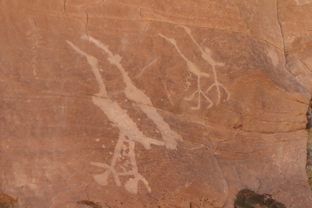
This canyon contains several petroglyph sites. In the first group, we saw a scene that we interpret as a party with individuals dancing in front of a crowd. Also note how these works have been treated in the past with gunshot marks on the right.

In some places, the ground was carpeted with small pink flowers.

Some rocks on the top of the cliff had strange shapes, including this one in the shape of a reptile's head.

The second petroglyph site contained carvings of birds. Indeed, we have seen a few birds resembling these flying a little before, with the same beak slightly curved downwards.
Most of these sites were easily identifiable by the presence of vehicle parking footprints. Several even had primitive trails to climb the embankment at the bottom of the cliffs to the petroglyphs.

Another site featured a hunting scene. The Ancestral Puebloans had no horses, these having been brought to North America by the Spanish first. This scene probably shows the first contact with the Spaniards mounted on horseback and hunting bison and antelope.

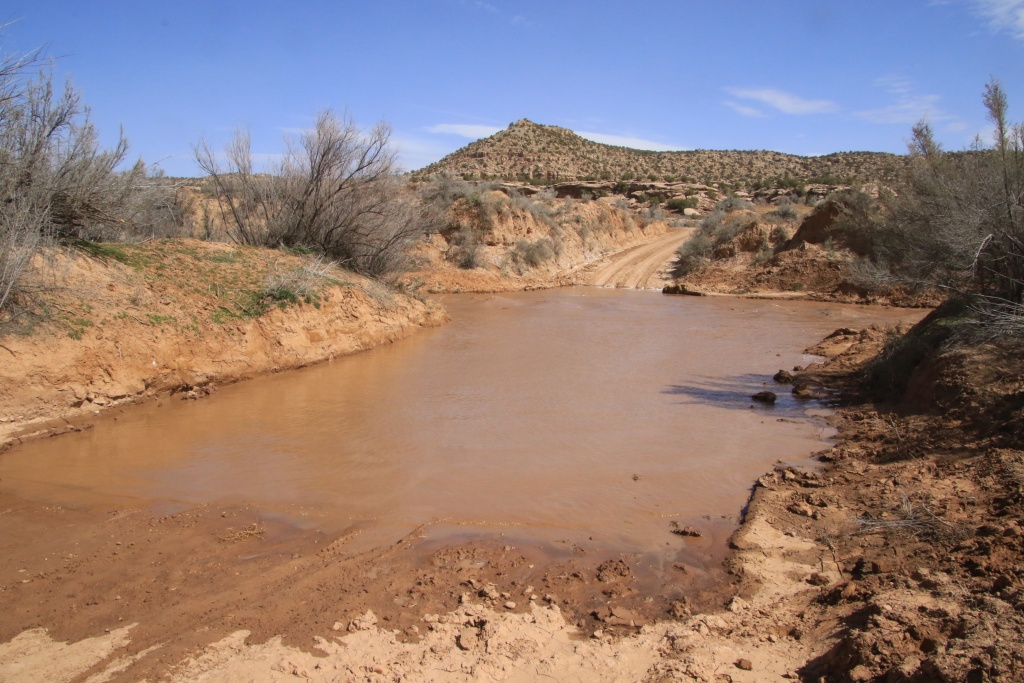
After driving about a third of Montezuma Canyon Road, we ran into a big obstacle; Montezuma Creek was flowing with a strong flow, bringing some debris with it and creating noticeable waves. Since the waters were loaded with sediment, it was impossible to visually assess the depth. I slowly advanced the 4Runner; the front wheels were already at axle height while the rear wheels were still out of the water. We wisely turned around.
Nearby, we saw a rancher busying himself with some chores. We spoke to him and strongly advised against attempting to cross this passage and the other streams, these being swollen by melting snow around the nearby Abajo Mountains. We therefore followed his recommendations and took a main gravel road leading directly to Blanding.
Then, looking to escape the strong winds and dust, we decided to reach The Needles sector of Canyonlands National Park. We had visited this one a few times before but not very often as it is quite remote. Unfortunately, winds and dust were also present there. We hiked the Scenic Drive and did some very short hikes. We should also go back there during our stay in Blanding.


The area is so named due to the presence of tall needle-like towers.

When we return, North Six-Shooter Peak seems to be fighting the dust to stay visible.

Tomorrow, the temperature will be much colder and the sun will be rare in Blanding. We will try to find an attraction a little far from the mountains to hope to find better weather.
__________________
2016 Trail Edition Classic Silver Metallic with KDSS, sunroof
ToyTec BOSS lift, SPC Light Racing UCA, RCI sliders, RCI aluminum full skids, RCI Cat Guard, Eezi-Awn K9 2.2m, BFG KO2 275/70R17E, FN Wheels f(X) Pro, ARB Breather kit, Husky WeatherBeater Mat and Cargo, XPEL window tint, 3M wrapped hood
Build thread
Adventures thread
|
|
|
Reply With Quote
|
 Posting Rules
|
You may not post new threads
You may not post replies
You may not post attachments
You may not edit your posts
HTML code is On
|
|
|
|


 Linear Mode


