 06-28-2017, 08:55 AM
|
#1
|
 |
Member
|
|
Join Date: Oct 2015
Location: Firestone, CO
Posts: 338
|
|
|
Member
Join Date: Oct 2015
Location: Firestone, CO
Posts: 338
|
Northern Colorado 4x4 Trails
Hey guys,
A friend and I are planning a trip mid August and need some help. We will be coming from Grand Junction to Winter Park and would like to not take highways but also only have one day to make it there. So I'm curious if there's any 4x4 trail that might make a short cut or even a detour with awesome views. Anything north or near i70? Thanks in advance
Sent from my SAMSUNG-SM-G930A using Tapatalk
__________________
2016 SR5P 4x4 Nautical Blue Nitto Ridge Grappler 285/75R17 ~ Stealth Custom Series SR8 ~ King Racing 2.5's ~ RCI Skids ~ Pelfreybilt Hidden Winch Mount Use "T4RZAN" at Rago Fabrication for 10% off Keep up with my adventures on Instagram: @_jacksonjenkins
|

|
 Reply With Quote Reply With Quote
|
|
06-28-2017, 10:05 AM
|
#2
|
 |
Member
|
|
Join Date: Feb 2012
Location: Fraser, CO
Age: 43
Posts: 603
|
|
|
Member
Join Date: Feb 2012
Location: Fraser, CO
Age: 43
Posts: 603
|
Take a look at this route
You could also get off 70 @ Wolcott and head up to Kremmling via Radium if you wanted to get there faster.
|
|
|
Reply With Quote
|
|
06-28-2017, 11:34 AM
|
#3
|
 |
Member
|
|
Join Date: Feb 2017
Location: Colorado
Posts: 177
Real Name: Paul
|
|
|
Member
Join Date: Feb 2017
Location: Colorado
Posts: 177
Real Name: Paul
|
Quote:
Originally Posted by CO-Cygnus

Take a look at this route
You could also get off 70 @ Wolcott and head up to Kremmling via Radium if you wanted to get there faster.
|
Ha! I was going to suggest taking County Road 50 to Fraser also. Nice route! I was up there in early June and found the road gated about 5 miles out of Fraser. I would imagine it's open now, but you may want to call the Sulphur Ranger District before you go just to make sure. 
|
|
|
Reply With Quote
|
|
06-28-2017, 11:59 AM
|
#4
|
|
Member
|
|
Join Date: Oct 2015
Location: Firestone, CO
Posts: 338
|
|
|
Member
Join Date: Oct 2015
Location: Firestone, CO
Posts: 338
|
Right on! Thanks guys! Anyone have anything with a 4x4 trail involved? Would love to find a road that goes ever a pass but seems they're all way south
Sent from my SAMSUNG-SM-G930A using Tapatalk
__________________
2016 SR5P 4x4 Nautical Blue Nitto Ridge Grappler 285/75R17 ~ Stealth Custom Series SR8 ~ King Racing 2.5's ~ RCI Skids ~ Pelfreybilt Hidden Winch Mount Use "T4RZAN" at Rago Fabrication for 10% off Keep up with my adventures on Instagram: @_jacksonjenkins
|
|
|
Reply With Quote
|
|
06-28-2017, 12:47 PM
|
#5
|
 |
Elite Member
|
|
Join Date: Sep 2010
Location: Colorado
Age: 33
Posts: 5,317
Real Name: Jim
|
|
|
Elite Member
Join Date: Sep 2010
Location: Colorado
Age: 33
Posts: 5,317
Real Name: Jim
|
__________________
'13 Tacoma TRD-OR: The Spruce Goose. BUILD
'02 Sport Ed.- V2.0: The better build. Totaled BUILD 2.0
'02 Sport Ed.- V1.0: The college build Sold BUILD

|
|
|
Reply With Quote
|
|
06-28-2017, 01:08 PM
|
#6
|
|
Member
|
|
Join Date: Feb 2012
Location: Fraser, CO
Age: 43
Posts: 603
|
|
|
Member
Join Date: Feb 2012
Location: Fraser, CO
Age: 43
Posts: 603
|
Quote:
Originally Posted by T4RZAN
Right on! Thanks guys! Anyone have anything with a 4x4 trail involved? Would love to find a road that goes ever a pass but seems they're all way south
Sent from my SAMSUNG-SM-G930A using Tapatalk
|
There are plenty of trails up here, but none that will get you to WP from Grand Junction in a day.
|
|
|
Reply With Quote
|
|
06-28-2017, 02:40 PM
|
#7
|
|
Member
|
|
Join Date: Oct 2015
Location: Firestone, CO
Posts: 338
|
|
|
Member
Join Date: Oct 2015
Location: Firestone, CO
Posts: 338
|
That is kind of the problem that I have run into in searching for a route. There's so many roads and trails it's hard to find a place to start and know what the road is going to be like. I really want something that goes up at least near a pass. Everything I find seems to go down through a valley between peaks.
The route I've found so far is going north from Silverthorne. Then 3 to 32 to 50 over to Fraser.
__________________
2016 SR5P 4x4 Nautical Blue Nitto Ridge Grappler 285/75R17 ~ Stealth Custom Series SR8 ~ King Racing 2.5's ~ RCI Skids ~ Pelfreybilt Hidden Winch Mount Use "T4RZAN" at Rago Fabrication for 10% off Keep up with my adventures on Instagram: @_jacksonjenkins
|
|
|
Reply With Quote
|
|
06-28-2017, 03:45 PM
|
#8
|
|
Member
|
|
Join Date: Feb 2017
Location: Colorado
Posts: 177
Real Name: Paul
|
|
|
Member
Join Date: Feb 2017
Location: Colorado
Posts: 177
Real Name: Paul
|
Quote:
Originally Posted by T4RZAN
The route I've found so far is going north from Silverthorne. Then 3 to 32 to 50 over to Fraser.
|
3 goes over Ute Pass and is paved. I've used that road many times to access peaks in the area. Not sure about 32, but in looking at satellite views, it looks to be a smooth road. 50 is an easy road too, so probably none of your route will involve 4x4 driving. There are many side roads off of those main roads that you may be able to play around on, though. The whole area has been devastated by the pine beetle over the past several years, so expect to see lots of dead trees and possibly some logging vehicles, especially on the side roads.
I'd still call the ranger district just before going to make sure that everything you plan on taking is open.
|
|
|
Reply With Quote
|
|
06-28-2017, 04:00 PM
|
#9
|
|
Member
|
|
Join Date: Feb 2017
Location: Colorado
Posts: 177
Real Name: Paul
|
|
|
Member
Join Date: Feb 2017
Location: Colorado
Posts: 177
Real Name: Paul
|
If you have the time, and want a fun 4x4 route with great views, you could continue on Highway 9 north of the County Road 3 turnoff for a few miles to Forest Road 200, then take that east, past Haystack Mountain on up to the spine of the Williams Fork Mountains. You can continue southeast along the spine most of the way back to Ute Pass, but the road doesn't go through. It's an out-and-back drive, so you'd need to allow a couple of extra hours (or more) depending on how far you want to go. It's been a few years since I've driven it, but the first few miles are pretty rough and rutted. Nothing too tough for a 4Runner, but time-consuming. The road goes through some nice aspen groves higher up.
The turnoff for FR 200 is a couple miles north of the north end of the Green Mountain Reservoir. The road should show in a DeLorme Atlas for the state.
|
|
|
Reply With Quote
|
|
06-28-2017, 06:10 PM
|
#10
|
|
Member
|
|
Join Date: Feb 2012
Location: Fraser, CO
Age: 43
Posts: 603
|
|
|
Member
Join Date: Feb 2012
Location: Fraser, CO
Age: 43
Posts: 603
|
Depending on how much time you have in WP you can drive up to Corona Pass and check out the world from the top of the divide. You can't continue through the old tunnel to Boulder county anymore, unfortunately.
|
|
|
Reply With Quote
|
|
06-29-2017, 12:05 AM
|
#11
|
|
Member
|
|
Join Date: Oct 2015
Location: Firestone, CO
Posts: 338
|
|
|
Member
Join Date: Oct 2015
Location: Firestone, CO
Posts: 338
|
Quote:
Originally Posted by CO-Cygnus
Depending on how much time you have in WP you can drive up to Corona Pass and check out the world from the top of the divide. You can't continue through the old tunnel to Boulder county anymore, unfortunately.
|
Well dang. Had planned on going up to Corona Pass and through to Boulder after Winter Park. Thanks for the heads up!
__________________
2016 SR5P 4x4 Nautical Blue Nitto Ridge Grappler 285/75R17 ~ Stealth Custom Series SR8 ~ King Racing 2.5's ~ RCI Skids ~ Pelfreybilt Hidden Winch Mount Use "T4RZAN" at Rago Fabrication for 10% off Keep up with my adventures on Instagram: @_jacksonjenkins
|
|
|
Reply With Quote
|
|
06-29-2017, 12:32 AM
|
#12
|
|
Member
|
|
Join Date: Feb 2017
Location: Colorado
Posts: 177
Real Name: Paul
|
|
|
Member
Join Date: Feb 2017
Location: Colorado
Posts: 177
Real Name: Paul
|
Quote:
Originally Posted by T4RZAN
Right on! Thanks guys! Anyone have anything with a 4x4 trail involved?
|
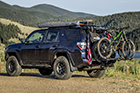
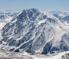
Attached are a few pictures and a topo map of the Williams Fork Mountains route that I described above. I did this trip in late September of 2011. Overall, you'll gain about 4,500 feet of elevation on this route, which starts at about 7,800 feet off of Highway 9 and reaches a high point along the road of around 11,400 feet (there are a few ups and downs). It's about 15 miles each way if you take the jog to the radio tower on the north and 13 miles if you skip that part. The black tracks on the map are the road. The red tracks are where I parked and hiked up to the summits that are along the way (the highest summit is 11,617 ft. Williams Peak). I think you'd enjoy this trip. The pictures below are: - The lower part of the road.
- Haystack Mountain from along the road. Fun, but tough, little climb to the top of this one.
- One of the many aspen groves you'd go through.
- A view along the way.
Last edited by PaulsTrail; 06-29-2017 at 12:51 AM.
|
|
|
Reply With Quote
|
|
06-29-2017, 09:05 AM
|
#13
|
|
Member
|
|
Join Date: Feb 2012
Location: Fraser, CO
Age: 43
Posts: 603
|
|
|
Member
Join Date: Feb 2012
Location: Fraser, CO
Age: 43
Posts: 603
|
Quote:
Originally Posted by T4RZAN
Well dang. Had planned on going up to Corona Pass and through to Boulder after Winter Park. Thanks for the heads up!
|
I think there might be a bypass route 'Over' instead of through, I have never tried and don't know the condition or exact location. Might be for bikes only.
Last edited by CO-Cygnus; 06-29-2017 at 09:13 AM.
|
|
|
Reply With Quote
|
|
06-29-2017, 09:21 AM
|
#14
|
|
Member
|
|
Join Date: Oct 2015
Location: Firestone, CO
Posts: 338
|
|
|
Member
Join Date: Oct 2015
Location: Firestone, CO
Posts: 338
|
Quote:
Originally Posted by PaulsTrail
Attached are a few pictures and a topo map of the Williams Fork Mountains route that I described above. I did this trip in late September of 2011. Overall, you'll gain about 4,500 feet of elevation on this route, which starts at about 7,800 feet off of Highway 9 and reaches a high point along the road of around 11,400 feet (there are a few ups and downs). It's about 15 miles each way if you take the jog to the radio tower on the north and 13 miles if you skip that part. The black tracks on the map are the road. The red tracks are where I parked and hiked up to the summits that are along the way (the highest summit is 11,617 ft. Williams Peak). I think you'd enjoy this trip. The pictures below are: - The lower part of the road.
- Haystack Mountain from along the road. Fun, but tough, little climb to the top of this one.
- One of the many aspen groves you'd go through.
- A view along the way.
|
Do you know roughly how long that route took you?
__________________
2016 SR5P 4x4 Nautical Blue Nitto Ridge Grappler 285/75R17 ~ Stealth Custom Series SR8 ~ King Racing 2.5's ~ RCI Skids ~ Pelfreybilt Hidden Winch Mount Use "T4RZAN" at Rago Fabrication for 10% off Keep up with my adventures on Instagram: @_jacksonjenkins
|
|
|
Reply With Quote
|
|
06-29-2017, 10:03 AM
|
#15
|
|
Member
|
|
Join Date: Feb 2017
Location: Colorado
Posts: 177
Real Name: Paul
|
|
|
Member
Join Date: Feb 2017
Location: Colorado
Posts: 177
Real Name: Paul
|
Quote:
Originally Posted by T4RZAN
Do you know roughly how long that route took you?
|
From the time stamps on my pictures, it looks like I started from Highway 9 around 7:30am and got back down to the highway around 1:30pm. But, that time includes stopping and hiking to 4 summits, and figuring out a way to the top of Haystack took some time. I'm guessing that my driving time was about 3 to 3.5 hours.
You could shorten the drive in a couple of ways. Skipping the jog out to the radio tower saves 2 miles, and there wasn't much to see. And, once you get to where I stopped to climb Williams Peak, the road narrows and goes into the deep forest on the east side, so there's not a lot to see past that point. So, skipping the radio tower and stopping at Williams Peak would shorten the drive to about 10 miles each way. Unless the road has deteriorated since I did it, you could probably make the roundtrip in under 2.5 hours.
|
|
|
Reply With Quote
|
 Posting Rules
|
You may not post new threads
You may not post replies
You may not post attachments
You may not edit your posts
HTML code is On
|
|
|
|


 Linear Mode


