Combined AZ Utah Parks Trip in May - Suggestions

Rock_Rat

Senior Member
My turn for your inputs.

Heading out to Flagstaff from Washington for the Overland Expo the weekend of May 12th - 15th. The rest of the itinerary looks like this:

Monday - Grand Canyon/ South Rim, Bright Angel Trail to the 3 mile turnaround. Drive to Page and stay in Hotel

Tuesday - Page to Zion NP at Springdale. Hike either Angels Landing or Observation Point and depart for camping in Bryce Canyon or stay in Zion (up in the air)

Wednesday
Bryce seems to be pretty much an overlook scenic type of canyon and not one you can immerse yourself in either by foot or by 4x4. If there's anything we should see there aside from the amphitheater please let me know. I'm still looking at a couple hours around Bryce and 4 hrs plus to drive to Canyonlands. So Wednesday seems to be taken.

Looking for possible Trail Options From Here
I have my wife with me so any hard trails is out of the question. She has her own agenda and it's visiting all the parks and getting there when recommended.

So I'm trying to plan out the next two days; Thursday - Friday (Sat and Sunday is driving from MOAB/Arches through SLC back home to Washington. Monday is a cushion day)

I was considering camping around Canyonlands first Wednesday evening and on Thursday AM head up to Island in the Sky. Time permitting I would like to head down the Shafer trail (Looks OMG exposed and scary!) to Potash and settle in at Arches. Friday Am up and around for some pics of delicate Arch etc and possibly some hiking and head back to SLC in Hotel.

Depart Saturday from SLC for home.

Any suggestions for the Wednesday through Friday part of this itinerary would be beneficial. I know trying to get all of this in in one week is impossible and unrealistic. I'll be saving Moab for another vacation.

I would love to include one maybe two off road trails during this trip if possible. If you think that this should just be a scenic tour only due to time constraints, don't hesitate to say so. Thanks! So basically what I'm looking for is:

"If it were me, after visiting Zion on Tuesday I would..."

Oh yea, one more caveat, my boys need to go back on Tuesday so I'm strapped in finding a way to get them to SLC or LAS to catch flights to Seattle and Los Angeles. This is why I'm heading to Zion first.
 
Last edited:
Register to hide this ad
Scenic and offroad go together to me. The prettiest places I've seen were not along an interstate. The days should be really long when you are there too, which will be to your advantage.

Shafer trail is a good choice. Nothing scary about it though, it's plenty wide for two vehicles. I like the idea of that trail and Potash if you're looking for easy scenic trails. You could also go a few miles down White Rim trail to the Colorado River Overlook and Muscleman Arch if that's something you're interested in.

Look and see if Shafer Campground is available for that night inside Canyonlands national park. That's where I stayed the first day I spent in Canyonlands. It's 1 mile down Potash after the switchbacks. Very nice campsite.

To do Arches this is my reccomendation if you are wanting to run trails, and see Arches. Go in on Willow Springs road, drive past the BLM campground, the road turns more into a trail, but it's nothing crazy. Eventually this will take you into the park through an opening in the fence. There is a sign saying you are entering the National Park so it isn't an illegal route or anything like that. Then you'll come to an intersection where this road intersects with Eye of the Whale Arch Trail. Take a left on this and it'll take you to Eye of the Whale arch which is a couple hundred yard hike from the trail. Then keep going on this trail until you get to a T intersection. Make a left here and this will take you to Tower Arch. This is a little bit longer of a hike, but nothing too intense at all. Takes 10-15 minutes max. This way you get to see arches, you're inside Arches National Park, you don't have to wait in the long line at the gate, and you avoid the super crowded touristy spots of the park. You would then go out the way you came in. None of these parts of the trails are difficult, the hard part of Tower Arch Trail is if you take a right at the T intersection. The worst parts are gonna be some very tilty sections along the trail, but it feels more scary than it is. No rock crawling or anything like that.

Eye of the whale is neat. The acoustics are kinda funky inside there, it's got a nice cool breeze blowing through it, and we were the only ones there for the 45 minutes we were stopped there.

Two more easy, scenic trails in Moab are Gemini Bridges, and Long Canyon. I also recommend Onion Creek, there's a really cool campground back there where we stayed also. PM me if you're interested and I can try and find you a GPS location of it. Onion creek is an easy trail, lots of creek crossings which are always fun. Onion Creek is also halfway between Moab and I-70 off of Highway 128. It's maybe 15-20 miles from Moab, and the same distance from the on ramp to interstate 70 to the North.
 
Great suggestions from [MENTION=116387]Unner[/MENTION]. Another easy trail that has good scenery is Hurrah Pass, and if you have more time, continue on to Chicken Corners.
 
Scenic and offroad go together to me. The prettiest places I've seen were not along an interstate. The days should be really long when you are there too, which will be to your advantage.

Shafer trail is a good choice. Nothing scary about it though, it's plenty wide for two vehicles. I like the idea of that trail and Potash if you're looking for easy scenic trails. You could also go a few miles down White Rim trail to the Colorado River Overlook and Muscleman Arch if that's something you're interested in.

Look and see if Shafer Campground is available for that night inside Canyonlands national park. That's where I stayed the first day I spent in Canyonlands. It's 1 mile down Potash after the switchbacks. Very nice campsite.

To do Arches this is my reccomendation if you are wanting to run trails, and see Arches. Go in on Willow Springs road, drive past the BLM campground, the road turns more into a trail, but it's nothing crazy. Eventually this will take you into the park through an opening in the fence. There is a sign saying you are entering the National Park so it isn't an illegal route or anything like that. Then you'll come to an intersection where this road intersects with Eye of the Whale Arch Trail. Take a left on this and it'll take you to Eye of the Whale arch which is a couple hundred yard hike from the trail. Then keep going on this trail until you get to a T intersection. Make a left here and this will take you to Tower Arch. This is a little bit longer of a hike, but nothing too intense at all. Takes 10-15 minutes max. This way you get to see arches, you're inside Arches National Park, you don't have to wait in the long line at the gate, and you avoid the super crowded touristy spots of the park. You would then go out the way you came in. None of these parts of the trails are difficult, the hard part of Tower Arch Trail is if you take a right at the T intersection. The worst parts are gonna be some very tilty sections along the trail, but it feels more scary than it is. No rock crawling or anything like that.

Eye of the whale is neat. The acoustics are kinda funky inside there, it's got a nice cool breeze blowing through it, and we were the only ones there for the 45 minutes we were stopped there.

Two more easy, scenic trails in Moab are Gemini Bridges, and Long Canyon. I also recommend Onion Creek, there's a really cool campground back there where we stayed also. PM me if you're interested and I can try and find you a GPS location of it. Onion creek is an easy trail, lots of creek crossings which are always fun. Onion Creek is also halfway between Moab and I-70 off of Highway 128. It's maybe 15-20 miles from Moab, and the same distance from the on ramp to interstate 70 to the North.

Great suggestions from [MENTION=116387]Unner[/MENTION]. Another easy trail that has good scenery is Hurrah Pass, and if you have more time, continue on to Chicken Corners.

OK so I'll be looking at everything tonight and trying to fine tune the logistics. Quick question on Wednesday's itinerary. What's the time window look like for Canyonlands coming from Bryce? It looks like one to two hours at Bryce and a four and half hr drive to Canyonlands. That would put me at around a noon or later arrival. How much time does it take to drive down Shafer to Potash >> Musclemans arch and back up towards Arches? What about Fuel? Can I get to Willow Springs road from Potash? I'm just using the interweb for info right now. Will order a guide to both Canyonlands and Arches tonight. Thanks guys! Awesome info!!!!

EDIT: It's looking more and more like a Sunday/Monday departure for Washington instead of Saturday/Sunday. Yay!!!
 
Shafer Trail took us 1.5 hours according to the time stamps on my photos, but we went slow, stopping a lot to take pictures. The Colorado River Overlook and Muscleman Arch are only a few miles from where Potash and White Rim Trail split. Maybe 20 minutes to get there, 20 minutes to get back to Potash, plus the time you spend at the sights. Not sure how long Potash takes, but it should be a pretty easy road. I saw a Corolla coming down Potash towards the Shafer Switchbacks.

Willow Springs Road is off of Highway 191, which is the main highway that runs through Moab. On Google Maps it shows the road I'm calling Willow Springs Road as BLM378. You won't need to worry about fuel for any of this. Top off in Moab, and you'll be good to run all of this. There is a gas station on HWY191 near where you turn off for Canyonlands, but they're ungodly expensive. I think gas was like $1 more a gallon than in Moab, which was already expensive.

If you haven't already I highly recommend getting the charles webb guide to Moab book. It's like $30, but super helpful in finding trails and getting difficulty ratings.
 
Don't think you should rush Canyon Lands area. You'll want to drive out to end of Island in the Sky before going down Shafer Canyon. If stay in Moab, be out at Dead Horse State Park Overlook for sunrise and can do Arches after or other Moab trails.

I've only been through Zion in March - but believe it gets real busy by mid-May and better have good plans to camp near there.

Alt. route out of Page along Vermillion Cliffs would be nice at sunrise. Page has great golf course.

I'd plan being up well before sunrise and out well past sunset - don't want to miss them. Nap in the afternoon!
 
Don't think you should rush Canyon Lands area. You'll want to drive out to end of Island in the Sky before going down Shafer Canyon. If stay in Moab, be out at Dead Horse State Park Overlook for sunrise and can do Arches after or other Moab trails.

I've only been through Zion in March - but believe it gets real busy by mid-May and better have good plans to camp near there.

Alt. route out of Page along Vermillion Cliffs would be nice at sunrise. Page has great golf course.

I'd plan being up well before sunrise and out well past sunset - don't want to miss them. Nap in the afternoon!

Shafer Trail took us 1.5 hours according to the time stamps on my photos, but we went slow, stopping a lot to take pictures. The Colorado River Overlook and Muscleman Arch are only a few miles from where Potash and White Rim Trail split. Maybe 20 minutes to get there, 20 minutes to get back to Potash, plus the time you spend at the sights. Not sure how long Potash takes, but it should be a pretty easy road. I saw a Corolla coming down Potash towards the Shafer Switchbacks.

Willow Springs Road is off of Highway 191, which is the main highway that runs through Moab. On Google Maps it shows the road I'm calling Willow Springs Road as BLM378. You won't need to worry about fuel for any of this. Top off in Moab, and you'll be good to run all of this. There is a gas station on HWY191 near where you turn off for Canyonlands, but they're ungodly expensive. I think gas was like $1 more a gallon than in Moab, which was already expensive.

If you haven't already I highly recommend getting the charles webb guide to Moab book. It's like $30, but super helpful in finding trails and getting difficulty ratings.

Scenic and offroad go together to me. The prettiest places I've seen were not along an interstate. The days should be really long when you are there too, which will be to your advantage.

Shafer trail is a good choice. Nothing scary about it though, it's plenty wide for two vehicles. I like the idea of that trail and Potash if you're looking for easy scenic trails. You could also go a few miles down White Rim trail to the Colorado River Overlook and Muscleman Arch if that's something you're interested in.

Look and see if Shafer Campground is available for that night inside Canyonlands national park. That's where I stayed the first day I spent in Canyonlands. It's 1 mile down Potash after the switchbacks. Very nice campsite.

To do Arches this is my reccomendation if you are wanting to run trails, and see Arches. Go in on Willow Springs road, drive past the BLM campground, the road turns more into a trail, but it's nothing crazy. Eventually this will take you into the park through an opening in the fence. There is a sign saying you are entering the National Park so it isn't an illegal route or anything like that. Then you'll come to an intersection where this road intersects with Eye of the Whale Arch Trail. Take a left on this and it'll take you to Eye of the Whale arch which is a couple hundred yard hike from the trail. Then keep going on this trail until you get to a T intersection. Make a left here and this will take you to Tower Arch. This is a little bit longer of a hike, but nothing too intense at all. Takes 10-15 minutes max. This way you get to see arches, you're inside Arches National Park, you don't have to wait in the long line at the gate, and you avoid the super crowded touristy spots of the park. You would then go out the way you came in. None of these parts of the trails are difficult, the hard part of Tower Arch Trail is if you take a right at the T intersection. The worst parts are gonna be some very tilty sections along the trail, but it feels more scary than it is. No rock crawling or anything like that.

Eye of the whale is neat. The acoustics are kinda funky inside there, it's got a nice cool breeze blowing through it, and we were the only ones there for the 45 minutes we were stopped there.

Two more easy, scenic trails in Moab are Gemini Bridges, and Long Canyon. I also recommend Onion Creek, there's a really cool campground back there where we stayed also. PM me if you're interested and I can try and find you a GPS location of it. Onion creek is an easy trail, lots of creek crossings which are always fun. Onion Creek is also halfway between Moab and I-70 off of Highway 128. It's maybe 15-20 miles from Moab, and the same distance from the on ramp to interstate 70 to the North.

This is the final weekend at home before I take off for the expo. I was fortunate enough to pick up an overnight permit for the White Rim trail so I'm making adjustments to my schedule almost daily. My plan now is to head into Arches on Wednesday via Willow springs and follow a similar if not the same route that [MENTION=116387]Unner[/MENTION] did. Thursday morning we'll visit Dead Horse State Park and head out to Island In the Sky. We'll head down Shafer to the White Rim in the afternoon, drive half way and camp overnight. Friday we'll continue the rest of the Trail and hopefully come out via Mineral Bottom. I'm a bit concerned about flooding of the Green river which will force us to turn around and go back another 80 miles.
 
This is the final weekend at home before I take off for the expo. I was fortunate enough to pick up an overnight permit for the White Rim trail so I'm making adjustments to my schedule almost daily. My plan now is to head into Arches on Wednesday via Willow springs and follow a similar if not the same route that [MENTION=116387]Unner[/MENTION] did. Thursday morning we'll visit Dead Horse State Park and head out to Island In the Sky. We'll head down Shafer to the White Rim in the afternoon, drive half way and camp overnight. Friday we'll continue the rest of the Trail and hopefully come out via Mineral Bottom. I'm a bit concerned about flooding of the Green river which will force us to turn around and go back another 80 miles.

Just make sure you leave adequate time to try and do white rim while the sun is still up. The views are breathtaking, you won't want to miss them. What campsite did you get?

The green River would have to be very flooded to impact White Rim Trail, I think. If it's something you're really worried about I suggest going by the Canyonlands ranger office in Moab. (2282 SW Resource Blvd. Moab, UT 84532). I went by there and talked to a ranger about the trail and he gave me all sorts of good information before I headed out. I'm sure they'd be able to tell you if there are any problems along the trail.

It should be an awesome trip! I'm looking forward to a trip report from you!
 
Just make sure you leave adequate time to try and do white rim while the sun is still up. The views are breathtaking, you won't want to miss them. What campsite did you get?

The green River would have to be very flooded to impact White Rim Trail, I think. If it's something you're really worried about I suggest going by the Canyonlands ranger office in Moab. (2282 SW Resource Blvd. Moab, UT 84532). I went by there and talked to a ranger about the trail and he gave me all sorts of good information before I headed out. I'm sure they'd be able to tell you if there are any problems along the trail.

It should be an awesome trip! I'm looking forward to a trip report from you!

Thanks Unner. The only place available was Airport A which is only 19 miles from Shafer. I figure this gives me plenty of time to catch the sunrise at Deadhorse and make a run out to Island in the Sky before going down Shafer. I don't want to get to the campsite too early. If it's not flooded, I should be able to complete the trail on Friday.

I have the number for the ranger station. There's an Alert posted on the NPS site and with my packet, warning visitors of potential flooding between Potato Bottom and Labrynth. Apparently, the river is at its highest between May 15th - June 30th.

I'm meeting up with a buddy of mine from Ogden on Saturday. He wants to do Top of the World. What do you think? You did it. Lot's of ledges and steps.

EDIT: BTW I just read through your trip report again for the third or fourth time. Great photos! Nice vibrant colors.
 
Last edited:
Too bad you have so little time and the wife along-

First time I did Bryce I was there for ten days. There are lots of hiking trails to do. Many of the trails down from the ridge through the hoodoos; A few more from the bottom (town of Tropic); more from the end of the road at about 9000 feet; even more on the opposite side of the park road. Even lots of non-park land in the area for off-road vehicle driving. Been back a couple other times with the wife - Not near as much fun as she's not a hiker.

Canyonlands is another place where you can hike forever. Did that for a week.

Zion you are correct- Lots of people in the main canyon and mostly just "scenic views". If you go around to the north side of the park the hiking is much better and few people.

Island in the Sky - near Moab (and where you catch the top of the Shafer Trail) the are a lot of hiking and 4 wheeling available all over the mesa. Another area where a week long stay is better.

It's hard for me to imagine going to Utah and spending half a day at each park.
 
Thanks Unner. The only place available was Airport A which is only 19 miles from Shafer. I figure this gives me plenty of time to catch the sunrise at Deadhorse and make a run out to Island in the Sky before going down Shafer. I don't want to get to the campsite too early. If it's not flooded, I should be able to complete the trail on Friday.

I have the number for the ranger station. There's an Alert posted on the NPS site and with my packet, warning visitors of potential flooding between Potato Bottom and Labrynth. Apparently, the river is at its highest between May 15th - June 30th.

I'm meeting up with a buddy of mine from Ogden on Saturday. He wants to do Top of the World. What do you think? You did it. Lot's of ledges and steps.

EDIT: BTW I just read through your trip report again for the third or fourth time. Great photos! Nice vibrant colors.

[MENTION=116467]Rock_Rat[/MENTION]

Sorry I didn't get back into town until today. Airport is a nice campground. Your schedule should definitely be doable.

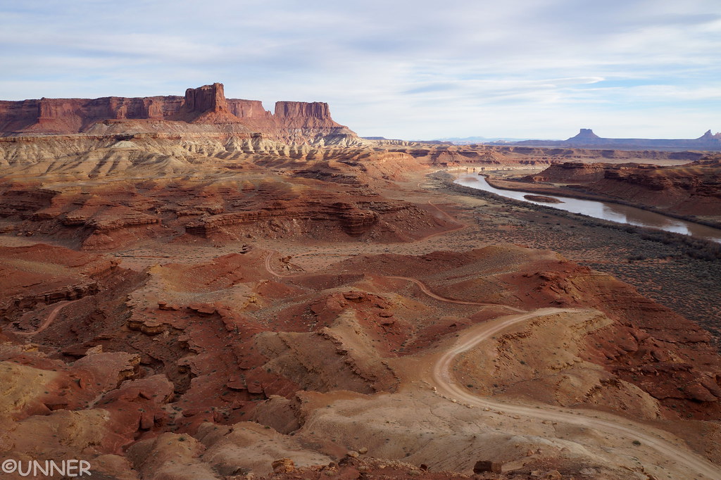
Hmmm. Potato Bottom and Labyrinth are at the very end of the trail. Hopefully it'll be open for you. Hardscrablle hill is right in between and one of the most fun parts of the trail. Super steep climbs with a sheer drop out your driver side window. If you think Murphy's hogback is steep, this one will knock your socks off. I liked this part too because you can look back over the trail you just covered and see the river. Beautiful.

DSC06765a by Unner Unner, on Flickr

Top of the World is amazing. I highly recommend it. It's slow going, but you can make it in your truck for sure. I recommend going with someone if you can so that'll work out good if you can go with your buddy. There's lots of opportunities for pictures of scenery, and your rig in action on Top of the World. You'll really put your suspension to the test too. Lots of flexing. The guy behind me said after we ran the trail "You've really got that rear suspension dialed in, I've been watching it all day and I'm amazed how it moves over the rocks."

Give yourself 4-5 hours probably to do the trail. Once you get to the top you'll look back over the way you just came which is a nice view, then you go up to the cliff edge and you'll be floored. Pictures don't do it justice. Top of the World is a bucket list trail in my opinion. It's one of the trails I was set on running when we drove out from Alabama, I was gonna make it happen.

Thanks for the compliments on the trip report, I'm glad you enjoyed it and that it can be used as a reference. That was my intent. I wish I could meet you out there and do some more Utah wheeling!
 
You better get a pic at Top of the World, that's my ultimate photo goal in life!
Have fun & safe travels. Watch out for those dirtbikes!
 
Just Wanted to close up this thread

Our trip to Arizona and Utah turned out fantastic with very few "speed bumps." All went as planned. You guys that contributed to this thread really made it happen. I'll be doing a trip report in my build sometime but for now I just wanted to give you a quick overview:

Left for flagstaff to attend the Overland West Expo which was better than I ever expected. The folks I met and the training I received was absolutely world class! My wife flew in to Vegas so I picked her up before settling in the Fort Tuthill recreation area. My son flew in from Seattle to meet us on Sunday night before we left for the Grand Canyon.

We left for the GC on Monday morning and managed to hike the 12 mile Bright Angel Trail and a section of the South Rim before moving on. I've never been to UTAH and this was an amazing sight to see. You'll hear this over and over agian from everyone - "Pictures just doesn't do it any justice." They are right! Nothing but being there can ever capture the magnitude of this awesome sight. At the end of the day, we drove to Page (near Lake Powell) just to split the drive in half on our way to Zion NP.

Left Page very early to try and get as much of the Park in as possible. Zion NP is absolutely mind blowing. I WILL go back there again. We kept it easy and just did the Riverside walk all the way down to the narrows. The narrows were off limits because of the water level. A little disappointing as I was really looking forward to that part of the hike.

From Zion I had to get my son over to St George for the shuttle to Vegas. Unfortunately, he had to go back to Seattle for work. Had dinner at Wildcat Willies just on the otherside of the west entrance of the park in St George - OMG awesome rack of ribs!

To stay on schedule, my wife and I needed to leave for Bryce Canyon. Left for Bryce and at the recommendation of a friend, we stayed at Ruby's Inn and Campground. Fantastic Campground. We were up before the break of dawn hoping to catch a sunrise but it just wasn't going to happen. Instead we were graced with snow! So we bagged the idea of a sunrise and did the peek-a-boo hike down into the canyon.

From Bryce we were heading over to Canyonlands, Arches and MOAB. Drove up 89 to catch the highway over to Canyonlands and we were in blizzard conditions the entire drive until we dropped in elevation. Once on the road into Canyonlands I kept my eye out for Willow Springs road. Yes! Found it on the left and was able to get into Arches before nightfall. I was good on gas so we decided to explore as long as we could before heading out to settle in for the night.

We arrived at Canyonlands "Island in the Sky" the next day with a little more than 1/4 tank of gas gone. A bit concerned as I was getting ready to head down into the canyon. No services at the entrance and I wasn't sure if I would be able to do the White Rim Trail. I had 6 gallons of gas with me so not overly concerned.

We took the Shafer trail into the canyon and drove Lathrop Canyon down to the river and took Potash out to MOAB over the next couple of days. The Green River was too high to complete the White Rim (so we were told). Camped at Airport A with just one other rig. A father-son team in a white Tacoma.

EDIT: Before moving into MOAB we took the tourist hike up to Delicate Arch. It was definitely the quintessential photo you see in all the Utah promotional material. Again, an awesome sight to see. I was disappointed, actually pretty pissed to see people standing in the center of the arch for photos. Not just for a quick pic but for 10 fifteen minutes at a time. All the more reason to why we Overland and avoid the beaten path and as Robert Frost so eloquently said, "And I, I took the road less traveled by and that has made all the difference."

Our final push was for MOAB. We stayed at the KOA campground in MOAB and on every street corner there were RZR's. Yes, it was RZR week. Lucky us! I only had time to do one "official" trail while in MOAB and Fins and Things was higher on my list than Top of the World. We did Fins and Things without any problems. I didn't take any of the alternates. My wife did a fantastic job with the marshaling duties AND camera duties. We were leaving that night so I had time for one more "official" MOAB trail and we decided to just take Long Canyon over to 313 after we filled up.

All in all, it was an extremely successful adventure! We got a chance to get our hiking in, attend the expo, see some fantastic National Parks, experience, Canyonlands and MOAB. Wonderful taste of Utah and we will go back again with more focus on Zion and MOAB.

Again, thanks for ALL of your input. I will post up a report in my build. I'm just incredibly busy right now as I do work for a living and I'm also preparing to do the OBDR in a few weeks.:thanks::thanks::thanks::thanks:
 
Last edited:

Members online

Forum statistics

Threads
278,316
Messages
3,554,120
Members
248,016
Latest member
Advally Service

Trending content

Back
Top