
Death Valley?

Your lines are a tad wonky, (And that marker for teakettle junction is WAY off!)

But it's all easy from Big Pine to Eureka dunes, 2 hours or less.

Then you are going through Dedeckra Canyon and Steel Pass. Some steep narrow spots (Fun!) at the start, but 33s get you through no problem. Then 20 miles or so of baby heads! From Eureka to the saline hot springs is about 3 hours of rough travel. Kind of tedious after a while :) Saline hot springs are near that 90 elbow in your rout around tin mountain.

Then it looks like you are heading out the standard north pass route through the yellow circle. The only issue with north pass is that it is probably STILL technically closed. BUT the only reason is a deep trench on the road near the top of the valley. When you start going over some Small hills in the road, watch out, it comes up as a surprise at the bottom of one. You can easily go around it and continue on up into the mountains and down to Big Pine. That would be 2-3 hours depending on sight seeing along the way.

If you started at big pine and finished at big pine in one shot with rest breaks you could do it in a day.

Here is a pic of the reason north pass is (was?) closed:

View attachment 181669

And some pics of the route from Eureka dunes to Big Pine and a little beyond (Drive in mine near Manzanar)

http://www.toyota-4runner.org/5th-gen-t4rs/165542-warthog-build-adventure-thread-30.html#post2195383

Cool, thanks for all the info. You have to zoom in really close for the roads to actually show up on Google, so I just made the roughs lines where I remembered them being.

Our plan would probably be to go drive from Reno to Eureka Dunes on a Friday. Have all Saturday to continue exploring, then head back out through Big Pine and back to Reno on Sunday. I'm cool with going further south than I drew in my map, so where would you recommend we camp for the second night, since it sounds like for a 3 day trip we could up the mileage?
 
Cool, thanks for all the info. You have to zoom in really close for the roads to actually show up on Google, so I just made the roughs lines where I remembered them being.

Our plan would probably be to go drive from Reno to Eureka Dunes on a Friday. Have all Saturday to continue exploring, then head back out through Big Pine and back to Reno on Sunday. I'm cool with going further south than I drew in my map, so where would you recommend we camp for the second night, since it sounds like for a 3 day trip we could up the mileage?

For three days, camping at eureka first night would be good. You could then go up/down the short fun section of Dedeker canyon if you wanted right behind the dunes, but then head back north to the main road and head east over the mountain, There is a sulfur mine up there, good for a quick picture stop.

Then south down death valley road to Ubehebe crater road, look at the craters, then continue on racetrack valley road, teakettle junction, racetrack, then down lippincott to saline valley, head north again and camp the second night at the saline hot springs. Then be set for the 2 hour drive back to big pine on the third day.

You would see a lot more scenery that way. Probably spend most of the second day driving but driving is exploring is scenery. I don't mind driving for the entirety of my outtings :D Might want to make sure you have enough gas to make the larger 3day trip. Carry extra if not sure... There is no close place to get gas. If you get to the ubehebe crater road turn off and you decide you NEED gas, you can drive 25-30 further south past ubehebe crater road turnoff on Death Valley road and get gas at Stovepipe Wells, then back up and take Ubuhebe road again, course that'll cost an hour of driving, but you will pass by more neat scenery and the central valley dunes along the way...
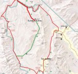
Though if you just wanted to relax. Camp at Eureka, then go through Dedeker Canyon and Steel Pass as I think your first map showed to the hot springs and camp there for the second night. Maybe drive around saline valley some. Then out north pass on the third day.

Make sure you have a decent death valley map before going!!! One wrong turn and you could end up lost of out of gas and up to the mercy of someone finding you O.O Oh and the upper end of the north pass road is labeled "Big Ping Rd" on some maps.
 
Last edited:
For three days, camping at eureka first night would be good. You could then go up/down the short fun section of Dedeker canyon if you wanted right behind the dunes, but then head back north to the main road and head east over the mountain, There is a sulfur mine up there, good for a quick picture stop.

Then south down death valley road to Ubehebe crater road, look at the craters, then continue on racetrack valley road, teakettle junction, racetrack, then down lippincott to saline valley, head north again and camp the second night at the saline hot springs. Then be set for the 2 hour drive back to big pine on the third day.

You would see a lot more scenery that way. Probably spend most of the second day driving but driving is exploring is scenery. I don't mind driving for the entirety of my outtings :D Might want to make sure you have enough gas to make the larger 3day trip. Carry extra if not sure... There is no close place to get gas. If you get to the ubehebe crater road turn off and you decide you NEED gas, you can drive 25-30 further south past ubehebe crater road turnoff on Death Valley road and get gas at Stovepipe Wells, then back up and take Ubuhebe road again, course that'll cost an hour of driving, but you will pass by more neat scenery and the central valley dunes along the way...

Though if you just wanted to relax. Camp at Eureka, then go through Dedeker Canyon and Steel Pass as I think your first map showed to the hot springs and camp there for the second night. Maybe drive around saline valley some. Then out north pass on the third day.

Make sure you have a decent death valley map before going!!! One wrong turn and you could end up lost of out of gas and up to the mercy of someone finding you O.O Oh and the upper end of the north pass road is labeled "Big Ping Rd" on some maps.

Awesome, thanks for sharing all this knowledge. I will definitely do some further research. This will be my first overland trip, so I still need to get some extra gear. One good thing is I haven't sold my old Trail Edition wheels/tires yet, so I'm thinking it would be a good idea to bring one for an extra spare. All this has got me pretty excited so thanks to everyone who contributed to this thread.
 
Awesome, thanks for sharing all this knowledge. I will definitely do some further research. This will be my first overland trip, so I still need to get some extra gear. One good thing is I haven't sold my old Trail Edition wheels/tires yet, so I'm thinking it would be a good idea to bring one for an extra spare. All this has got me pretty excited so thanks to everyone who contributed to this thread.

DEFINATELY have a spare on you, both steel pass and the racetrack roads are potential wheel poppers. Be sure to be aired down etc. I am assuming you do have tires/lift and experience. If you can find a second vehicle to go with you that's always a great saftey measure.

Overall these roads are all fairly mainstream for offroaders, so even if something did happen, there'd be someone along in not too long.

Take pictures! :)
 
Awesome, thanks for sharing all this knowledge. I will definitely do some further research. This will be my first overland trip, so I still need to get some extra gear. One good thing is I haven't sold my old Trail Edition wheels/tires yet, so I'm thinking it would be a good idea to bring one for an extra spare. All this has got me pretty excited so thanks to everyone who contributed to this thread.

I don't understand your map. I think you meant something like this?

I don't see any roads that connects near steel pass (green) to the road on the east over Last Chance Range (at least based on the USG Topo map).

A good map or GPS is strongly recommended. Even this map I downloaded from their website isn't enough. I bought the Gaia GPS app on my iPhone by downloading the DV section, marking intersections prior to the trip. I definitely did not want to get lost out there.

Next time, I will have to explore the northern parts of DV.
 

Attachments

  • Screen Shot 2016-03-12 at 1.03.41 AM.jpg
    Screen Shot 2016-03-12 at 1.03.41 AM.jpg
    107.4 KB · Views: 354
I was just searching DV trips and thinking about making one leaving from Oregon. It would be next week when my daughter on on spring break. Anyone else going there? Would be nice to have a 2nd vehicle as its my first trip down.
 
[MENTION=107267]4Rager[/MENTION]

When were you thinking of making the trip?

We were thinking one of the first two weekends in April. I just drove to LA and back on 395 this weekend and the scenery made me even more excited to get off the highway and explore DV.
 
I don't understand your map. I think you meant something like this?

I found it on Google maps where you have to zoom in a lot to see it, but it's looks like a continuation of the dirt road that goes to Eureka Dunes (campground at the very top left). However it might not be a very well publicized road, since according to others in this thread, you need 33's to make it through. It looks like right next to your green line near the middle it says "road conditions require experienced 4 wheel drivers", so I'm thinking it's designated as one of the high-clearance vehicle trail.

EDIT: I just found the map you used above and was about to link it until I realized it was the same one. In the legend at the bottom it shows a dashed line like that requires a high clearance 4wd, but that 8" of ground clearance will do. There's one higher difficulty that says 12" of ground clearance, which is pretty much 35's minimum. Those must be pretty cool. http://www.nps.gov/deva/planyourvisit/upload/Backcountry-Roads-Map.pdf


C3dtKqZ.png
 
Last edited:
I found it on Google maps where you have to zoom in a lot to see it, but it's looks like a continuation of the dirt road that goes to Eureka Dunes (campground at the very top left). However it might not be a very well publicized road, since according to others in this thread, you need 33's to make it through. It looks like right next to your green line near the middle it says "road conditions require experienced 4 wheel drivers", so I'm thinking it's designated as one of the high-clearance vehicle trail.

EDIT: I just found the map you used above and was about to link it until I realized it was the same one. In the legend at the bottom it shows a dashed line like that requires a high clearance 4wd, but that 8" of ground clearance will do. There's one higher difficulty that says 12" of ground clearance, which is pretty much 35's minimum. Those must be pretty cool. http://www.nps.gov/deva/planyourvisit/upload/Backcountry-Roads-Map.pdf

I got through on the green line trail with 32's. Can't remember if I had to stack a rock on that one or not, but even if so it wasn't too bad. And the longer red route through lippencot I haven't done but someone just went through on stock tires I believe.

So I think 32s or above should do either ok.
 
I got through on the green line trail with 32's. Can't remember if I had to stack a rock on that one or not, but even if so it wasn't too bad. And the longer red route through lippencot I haven't done but someone just went through on stock tires I believe.

So I think 32s or above should do either ok.

Nice. If you read the description on the bottom of the maps it says "...4wd SUV or truck type vehicle with at least 15" tires..." ummm what?
 
The trail past Eureka Dunes is called Steele Pass. You leave the dunes, and head into the Last Chance Range through Dedeckera Canyon . In Dedeckera you will find a few rock stair step obstacles , but most any 4x4 can get through it . After the canyon, it opens up and you will reach Steele Pass. As you descend down Steele into the Saline Valley , it gets pretty rough and rocky , but again , a 4x4 and common sense will get you through .

This route is very remote though , not a good place to have a problem . It is getting more and more popular with the overlanding crowd , so I doubt it would be too long before someone came by to lend a hand ... the scenery is second to none .

I actually made a movie of my wife driving through some of the challenges in Dedeckera...

https://www.youtube.com/watch?v=nYPQTYyxy-0
 
Frankly if you go out alone and especially if you don't have a real trail map you will be in a bad spot.

Buy a real map. This is a must. I suggest a the national geographic death valley map.

Also use a digital map guide such as BackCountry Navigator Pro.

Cell phone reception? Try again. Get ready to spend literally a hundred miles of driving without cell reception in Death valley and that is on the paved roads. In the BackCountry you will be on your own.

Trail markings? Haha haha haha haha ... Yeah right. You are on your own. No clear tail markings off pavement.

I've been on three 4wd trips to death valley and even I still have a hard time figuring things out. My only saving grace has been BackCountry Navigator app with its GPS off-cell-grid and downloadable detailed maps.

BTW, is there even camping near the dunes? I see there is one official site. Definitely use that spot. Camping off trail might not be possible. It is totally exposed to the wind and the whole area is not in a good spot for camping.

Steel pass is not very rough, at least it wasn't three years ago.

:plane:
 
Last edited:
There is designated camping at Eureka, pullouts , tables, fire rings , even a baño... but you're right no shade what so ever .... kind looks like this :

GOPR0025_zps463645dc.jpg~original
 
I found it on Google maps where you have to zoom in a lot to see it, but it's looks like a continuation of the dirt road that goes to Eureka Dunes (campground at the very top left). However it might not be a very well publicized road, since according to others in this thread, you need 33's to make it through. It looks like right next to your green line near the middle it says "road conditions require experienced 4 wheel drivers", so I'm thinking it's designated as one of the high-clearance vehicle trail.

I am just little worried at your comment of planning on you trip on google maps because you will not have cell service.

Frankly if you go out alone and especially if you don't have a real trail map you will be in a bad spot.

Buy a real map. This is a must. I suggest a the national geographic death valley map.

Also use a digital map guide such as BackCountry Navigator Pro.

Cell phone reception? Try again. Get ready to spend literally a hundred miles of driving without cell reception in Death valley and that is on the paved roads. In the BackCountry you will be on your own.

Trail markings? Haha haha haha haha ... Yeah right. You are on your own. No clear tail markings off pavement.

I've been on three 4wd trips to death valley and even I still have a hard time figuring things out. My only saving grace has been BackCountry Navigator app with its GPS off-cell-grid and downloadable detailed maps.

BTW, is there even camping near the dunes? I see there is one official site. Definitely use that spot. Camping off trail might not be possible. It is totally exposed to the wind and the whole area is not in a good spot for camping.

Steel pass is not very rough, at least it wasn't three years ago.

:plane:

Thus, this is probably the best advice, a GPS and/or a good map.

I bought the GAIA GPS app on my iPhone and downloaded the entire DV section of the USG Topo map to use offline, studied it carefully, and it worked perfect in DV.

Good luck!
 
Don't worry, Google Maps only serves as getting a general idea familiarizing myself with the area while I'm not busy at work. I will definitely be buying more detailed maps and GPS apps. I think the person I'm going with has a handheld GPS as well, and has been there a number of times, just not on the 4x4 trails. I just ordered the Nat Geo DV map so now I just need to get familiar with the GPS apps.
 

Members online

Forum statistics

Threads
278,307
Messages
3,554,056
Members
248,016
Latest member
Advally Service

Trending content

Back
Top