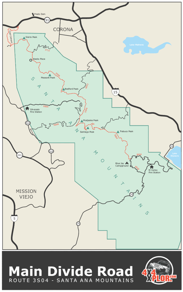
Orange, CA (Santiago Peak)

prodigy2k7

New member
Has anyone here been to Santiago Peak?
What is the trail called that goes up to it?
I remember going down chapman really far, turning left on a turn off and going through windy roads through tight residential on left and right side of main road. Then you get to the gate, its now closed because of the fires.

Anyone have any input on this fun trail?
Any idea when it will re-open?

For those who dont know, its an awesome trail that basically goes up a mountain to a max height of 5,687 FT (1,733 M)

Short youtube video of the top:
http://youtube.com/watch?v=zxAN3rze1eQ
 
Register to hide this ad
Hi, I've been up there a few times last year before the fire. It is a great ride, and the view from up there is fantastic.

I suspect that access will be closed for sometime. I really couldn't say how long, but I'm betting at least until May or up to a year. I hope I'm wrong and it opens sooner though.
 
It's a great ride.

The road there is through Silverado Canyon. The gate is usually closed half the year (I forget if it's winter or summer) because some endangered frog's mating season.

But you can always access the road from Ortega Hwy (74)...You can take the trail all the way too the radio towers...then on past Silverado. Only problem with coming in via the 74 when the Silverado gate is closed is that you need to back track to the 74 or take the dirt road all the way to the 15 or 91? (Sorry can't remember which one it was...)

If you stick to the graded road, no 4wd is needed...there are some nice "play" areas to lock it up though.
 
Current condition: From HWY 74 you can only get to Indian Truck Trail as the gate to the towers is closed at that juncture. You can take the turn there and get to the 15 Fwy, or go back to Ortega.

If you can get up there without the marine layer, and/or a windy day blowing the crud out of the air there is a real good view of Catalina Island from that stretch.

Silverado entry is typically closed Oct/Nov through March/April as mentioned for the breeding season of the Arroyo Toad. A seldom seen inhabitant with dwindling habit throughout it's range.
 
Zmtking said:
Current condition: From HWY 74 you can only get to Indian Truck Trail as the gate to the towers is closed at that juncture. You can take the turn there and get to the 15 Fwy, or go back to Ortega.

If you can get up there without the marine layer, and/or a windy day blowing the crud out of the air there is a real good view of Catalina Island from that stretch.

Silverado entry is typically closed Oct/Nov through March/April as mentioned for the breeding season of the Arroyo Toad. A seldom seen inhabitant with dwindling habit throughout it's range.

Do you think that road is closed due to the fire also? or JUST cuz the breeding season?

Do you foresee the opening of the trail in march/april?
 
Definitely closed now because of the fire. According to the USFS closure order the burn area is closed for use through Nov. 2008. This means the Silverado/Maple Springs Rd to Santiago Peak will be closed at least until then unless they cancel the order beforehand.

Whether they will open the gate to the peak from the N. Main Divide Rd is unknown, but I hope they will at some point this year. They are working on putting in a new gate at the peak (towers) that will prevent people from driving into the or entering the burn area or the Silverado side if you will. So in other words if they open the trail to the peak you will have to enter from Ortega Hwy, and go back down the same way.
 
Lol I have no idea about going around through there. Ive been there less than 10 times and I go from the 91 to the 55 off at chapman then go all the way up the hills/mountains. I take a left at some big turn off road go through some residential for a few miles then I hit a different trail paved somewhat, kinda dirty then i hit dirt roads going up to santiago peak and go all the way to the top...
 
Main Divide South is open and Main Divide North is partially open. The scenery is great, at least it was before the fires. The trail is mostly fire road and is passable by 2 wheel drive. There are a few very rocky sections, but again its rocky fire road and not "rock crawling". Along the trail are several off shoots and some present some pretty serious challenge. I'm sure the rains have added a few challenges to the terrain that I haven't seen. It's always a fun drive and simple to get to.

Depending on when, I'd be into making another trip. Attached are a few pics from my last trip.


Sunrise on the Main Divide North Road
MainDivide-Sunrise.jpg~original


Main Divide South - Looking South here
MainDivide-South-1.jpg~original


Another Scenic Shot of the Main Divide South
MainDivide-South2.jpg~original


At Modjeska Peak. This gives you an idea of the "rocky" terrain. This isn't bad here, some sections are much worse, but again it's passable, heck I still had the factory tires on here.
ModjeskaPeak.jpg~original
 
prodigy2k7 said:
What is open and how do you get there?
Is Modjeska Peak open?

It looks like you can still drive much of the trails, but you won't be able to get to the peaks. I might go check it out tomorrow, and if so I'll post an update and pics. I'm not 100% sure if the gate at Silverado Canyon is open.

Everything you need is here. http://www.fs.fed.us/r5/cleveland/

ROAD CLOSURES - Vehicle access on the following roads are restricted due to wet road conditions and/or fire/resource damage. www.fs.fed.us/r5/cleveland/conditions/

This is also a great site for information. this lists trails in most areas.

Dirtopia-splash.gif~original

http://www.dirtopia.com/wiki/Orange_County%2C_California
 
Yeah, thanks for the info I didn't know that.

Great pictures. Where off of the Main Divide South did you take those pictures from. I don't recall views like that from this road as it traverses the eastern side of the Santa Ana's.
 
Zmtking said:
Great pictures. Where off of the Main Divide South did you take those pictures from. I don't recall views like that from this road as it traverses the eastern side of the Santa Ana's.

To be honest, I don't remember exactly where these spots were. I took Maple Springs up to 3S04 Main Divide and I believe these are spots along that route. The first might be Maple Springs approaching Main Divide and the pictures looking south are on 3S04. Also, these would be on the western face.

Happy Trails

ClevelandNationalForest.gif~original
 
Here is another picture from 3S04 South. I think this is further down the trail and looking East. That's Lake Elsinore in the background.

IMG_6901.jpg~original
 
Falls said:
TR4FUN , what are you running for tires ? Did you do any lifting ?
Falls,

This was early in the life of my 4Runner. Still running the stock (trash) tires then, and the vehicle was completely stock.

To be honest, there are only a couple of (alternate route) spots that would require any lift or even 4 wheel drive. All the main trails are easily passable in a stock 4Runner, but I'd recommend more aggressive tires since the rocky sections get pretty nasty with a few sharp edges that could jump out and cut your average unsuspecting street tire.

If you are looking for more challenging sections and you have a lifted 4x4 4Runner, those sections can be found.
 
T4Rfun said:
Here is another picture from 3S04 South. I think this is further down the trail and looking East. That's Lake Elsinore in the background.

IMG_6901.jpg~original
Ok, that explains it. You were on the Main Divide North, not South. I thought as much.

FYI, the Main Divide North/South is separated by Ortega Hwy.
 
Zmtking said:
Ok, that explains it. You were on the Main Divide North, not South. I thought as much.

FYI, the Main Divide North/South is separated by Ortega Hwy.

My Bad.... I stand corrected
 

Members online

Forum statistics

Threads
278,312
Messages
3,554,085
Members
248,016
Latest member
Advally Service

Trending content

Back
Top