85straight
New member
2016 NEW YEARS MEET UP AND TRAIL RUN
Description:
The meet will be Friday, January 1st. The run will be family oriented with a few stops at some "attractions" with time to walk around and explore.
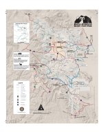
The run will begin near the southern end of the park at/near Blair Valley. Then onto Arroyo Tapiado to get to the mud caves.
After the mud caves drop down Diablo Drop-off* into Fish Creek Wash to explore the slot canyons.
Make our way North out of Fish Creek via Split Mountain.
Then meander our way around the badlands* and the svra stopping to check out Squaw Peak and the Pumpkin Patch.
Head to the gas station near Salton City to refuel.
Head west a few miles to play around in the obstacle course.
Head to Fonts Point to wrap up the day.
Current trail conditions:
http://www.parks.ca.gov/pages/638/files/road conditions 10-3-15.pdf
Difficulty: Easy
Meet Location:
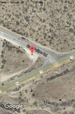
The corner of S2 and 78
33.098712, -116.471308
Meeting time:
10:00AM at the corner of S2(San Felipe rd) and 78 for Safety and Trail Meeting leaving for trail head immediately after. Please try to arrive prior to 10:00AM, I will be there early. Departure should be NLT 10:15AM.
We will be stopping for lunch on the trail, so bring snacks and pack accordingly!
Tentative Roster:
1. 85straight
2. ZachF (maybe)
3. 98WhiteT4R
4. Logan714 (maybe)
5.
6.
If I have missed anyone, please PM me and I'll add you to the list. I would like to verify our numbers before heading out. If you want off the roster, let me know in a PM.
What to bring with you:
Good Attitude - This group is big(maybe haha)...we'll need to be patient with each other
Snacks, food, beverages (no alcohol consumption en route please)
Spare fluids for vehicle
Recovery gear if you have it.
Recovery point front and rear (factory hook is fine)
Ranger Station Info:
Current conditions and park info
Anza-Borrego Desert SP
I would like this to be a optional camping trip but I cannot commit 100% at this time. For those that want to camp, speak up and I can throw some ideas out there and hopefully join you.
As always, I am open to all suggestions and comments.
---THANKS TO TheSentinel for the format---
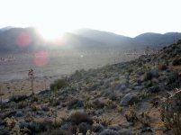
Picture from a trip earlier this year
Description:
The meet will be Friday, January 1st. The run will be family oriented with a few stops at some "attractions" with time to walk around and explore.
The run will begin near the southern end of the park at/near Blair Valley. Then onto Arroyo Tapiado to get to the mud caves.
After the mud caves drop down Diablo Drop-off* into Fish Creek Wash to explore the slot canyons.
Make our way North out of Fish Creek via Split Mountain.
Then meander our way around the badlands* and the svra stopping to check out Squaw Peak and the Pumpkin Patch.
Head to the gas station near Salton City to refuel.
Head west a few miles to play around in the obstacle course.
Head to Fonts Point to wrap up the day.
Current trail conditions:
http://www.parks.ca.gov/pages/638/files/road conditions 10-3-15.pdf
Difficulty: Easy
Meet Location:
The corner of S2 and 78
33.098712, -116.471308
Meeting time:
10:00AM at the corner of S2(San Felipe rd) and 78 for Safety and Trail Meeting leaving for trail head immediately after. Please try to arrive prior to 10:00AM, I will be there early. Departure should be NLT 10:15AM.
We will be stopping for lunch on the trail, so bring snacks and pack accordingly!
Tentative Roster:
1. 85straight
2. ZachF (maybe)
3. 98WhiteT4R
4. Logan714 (maybe)
5.
6.
If I have missed anyone, please PM me and I'll add you to the list. I would like to verify our numbers before heading out. If you want off the roster, let me know in a PM.
What to bring with you:
Good Attitude - This group is big(maybe haha)...we'll need to be patient with each other
Snacks, food, beverages (no alcohol consumption en route please)
Spare fluids for vehicle
Recovery gear if you have it.
Recovery point front and rear (factory hook is fine)
Ranger Station Info:
Current conditions and park info
Anza-Borrego Desert SP
I would like this to be a optional camping trip but I cannot commit 100% at this time. For those that want to camp, speak up and I can throw some ideas out there and hopefully join you.
As always, I am open to all suggestions and comments.
---THANKS TO TheSentinel for the format---
Picture from a trip earlier this year
Attachments


Last edited: