Canyonlands NP White Rim Trail Impassable

Riverfisher

New member
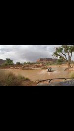
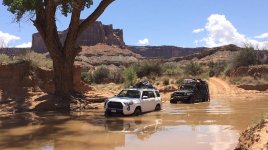
FYI-Heavy rain and runoff has washed out a portion of the White Rim Trail this week. It is currently impassable.

Utah Canyonlands National Park trail floods | KSL.com

The west side of the White Rim Road between Potato Bottom and Labyrinth campsites has been deemed impassable by the NPS due to flooding by the Green River.

Call the Island in the Sky visitor center for more information 435-259-4712


Sent from my iPhone using Tapatalk
 
Last edited:
Register to hide this ad
[MENTION=116467]Rock_Rat[/MENTION]

Not sure about the timing of your trip, but hopefully you see this or hear it somewhere else before you head out.
 
Depends on if you're willing to drive thru 2-3' of water. Me and a buddy Made it thru yesterday...
 

Attachments

  • IMG_2599.jpg
    IMG_2599.jpg
    42.7 KB · Views: 1,495
Last edited:
White Rim Unpassable

[MENTION=116387]Unner[/MENTION] and [MENTION=157565]Riverfisher[/MENTION] thanks for the update on the White Rim Canyon Closure. Prior to going into the canyon I checked with the Park Ranger and I also received the following email alert.

Based on that information, we drove as far as Hogback to look at the Candlestick Tower and since we were camping at Airport A we did the Lathrop Canyon down to the Colorado River. Fantastic trail! We left out of Potash which was a beautiful drive!
[MENTION=114923]tellurunner[/MENTION] I'm glad you guys made it!! That is awesome! Looks like I'll have to go back there again!
 

Attachments

  • White Rim Canyon eMail.jpg
    White Rim Canyon eMail.jpg
    119.6 KB · Views: 1,255
Got a permit yesterday for AirportD/Candlestick/Taylor for next week (someone must have cancelled). Talked to a ranger who said a week or so ago Upheaval Wash was under 60" of water, two days ago 30", yesterday 19". Changes in runoff from day-to-day dictate that there's probably no way to know what we'll find until we actually get there.

We're out for an adventure, so if it's impassable we'll reverse out to Moab for gas, and hit Taylor from the Mineral Bottom side. What the heck, more bang-for-the-buck...
 
Got a permit yesterday for AirportD/Candlestick/Taylor for next week (someone must have cancelled). Talked to a ranger who said a week or so ago Upheaval Wash was under 60" of water, two days ago 30", yesterday 19". Changes in runoff from day-to-day dictate that there's probably no way to know what we'll find until we actually get there.

We're out for an adventure, so if it's impassable we'll reverse out to Moab for gas, and hit Taylor from the Mineral Bottom side. What the heck, more bang-for-the-buck...

Hope you can do the entire rim, but if not, I would highly recommend going down the Lathrop Trail to the river. Fun little trail and a gorgeous drive. Places you right in the canyon.
 
Crossed Upheaval Wash yesterday, mostly 12" deep or shallower, with a brief spot at 16 to 18".

Does the Park Service have any depth gauges there, or do you just have to wade it or drive in and hope for the best? (not recommended, I wouldn't think) I would assume the water is muddy and impossible to see the bottom.
 
Does the Park Service have any depth gauges there, or do you just have to wade it or drive in and hope for the best? (not recommended, I wouldn't think) I would assume the water is muddy and impossible to see the bottom.

I kinda wondered about that myself before going. It changes on a day-to-day basis, sometimes radically. I doubt the Park Service wants to have any responsibility for whether or not people go all the way around (clockwise), have to turn back, then have people tell them "you told me I could get through!". Basically you go, hope a cell doesn't hit Upheaval Canyon or the Green isn't rising rapidly, walk it when you get there to determine where the high/low spots are, and yes, hope for the best.

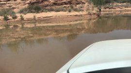
When we got there the water had clearly been at least 18" higher in the recent past (like [MENTION=114923]tellurunner[/MENTION] posted above, see hood shot of former waterline). The water is murky, but you can see bottom at 6" depth or less.

You always wonder about crossing these things when you've never been there before; I really wondered crossing this thing while pulling a 5000# jeep (Trip Report to follow).
 

Attachments

  • Upheaval Wash TOW.jpg
    Upheaval Wash TOW.jpg
    118.3 KB · Views: 4,227
  • Crossing Upheaval Wash.jpg
    Crossing Upheaval Wash.jpg
    134.1 KB · Views: 1,340
Last edited:
Thanks. I'm planning a trip around the White Rim next September (but may have to postpone to next April), and it's always good to have some first-hand reports about the more gnarly stuff. I doubt water will be a problem in Sept., however.

I'll be interested in the details of the Jeep story. Sounds like another case of "if you want to get deep into the back country, buy a Jeep. If you also want to get back out, buy a Toyota."
 
Thanks. I'm planning a trip around the White Rim next September (but may have to postpone to next April), and it's always good to have some first-hand reports about the more gnarly stuff. I doubt water will be a problem in Sept., however.

I'll be interested in the details of the Jeep story. Sounds like another case of "if you want to get deep into the back country, buy a Jeep. If you also want to get back out, buy a Toyota."

Trip Report posted!

http://www.toyota-4runner.org/5th-g...im-trd-trip-report-5-31-6-3-17-pic-heavy.html
 

Members online

Forum statistics

Threads
278,316
Messages
3,554,111
Members
248,016
Latest member
Advally Service

Trending content

Back
Top