Completion of the WABDR from Stevenson to Canada

Awesome trip report! I have been scoping this route for a couple years and this is a very good nudge for me to get out there and start planning. Thanks for sharing!
 
Thanks, it was truly EPIC! One of the best in quite some time. Most of the guys in the 3rd Gen section followed me during the trip. When I returned I thought it was a good idea to post up for all 4R's. Looking forward to doing the OBDR this summer after my road trip to Overland West in Flagstaff AZ. Best place to start is on the WABDR website and click on the Interactive Map link to the right. There's a good start for figuring out which section you want to do.
You've sold me on doing at least some of this this upcoming summer. Thanks for the great documentation!
 
:thumb: Thank you for the writeup, what a great trip. I'm inspired.
Thanks. Hopefully you get an opportunity to do part of, or an entire BDR.

Thanks for posting this. I've been considering driving this route this summer.

Fantastic! You'll enjoy it. Research a little history about the entire route and it makes it so much more enjoyable. Fingers crossed there aren't any fires.
 
Awesome trip report! I have been scoping this route for a couple years and this is a very good nudge for me to get out there and start planning. Thanks for sharing!

My pleasure. Now you don't have an excuse!! Get on out there and have fun. I still have a "lessons learned "post to add to this.
You've sold me on doing at least some of this this upcoming summer. Thanks for the great documentation!
Your'e quite welcome, glad it gave you a jump start. [MENTION=82154]GSPRunner[/MENTION] and [MENTION=63487]A.Wilson013[/MENTION] up in your neck of the woods have also completed most, if not all of the WABDR. I don't recall if they documented it all or not. Great resource. :thumb:
 
Rock_Rat, I enjoyed reading about your expedition! Your last few pics brought back some pleasant memories! I worked the ranch at the bottom of Chapacca grade before Loomis from 1975-1977! It was called Sheep Mtn Cattle Co. at the time. I had worked for the owner a few summers on his ranch on the south side of the Crazy Mtns, west of Big Timber, MT. The summer I graduated High School
he had sold that ranch and purchased the Palmer Lake spread. Remembering that time puts a smile on my face! Thank you for rekindling some great memories!
 
Rock_Rat, I enjoyed reading about your expedition! Your last few pics brought back some pleasant memories! I worked the ranch at the bottom of Chapacca grade before Loomis from 1975-1977! It was called Sheep Mtn Cattle Co. at the time. I had worked for the owner a few summers on his ranch on the south side of the Crazy Mtns, west of Big Timber, MT. The summer I graduated High School
he had sold that ranch and purchased the Palmer Lake spread. Remembering that time puts a smile on my face! Thank you for rekindling some great memories!

That's awesome! Glad to re-kindle some old memories. That section of the drive, although the shortest, was absolutely breathtaking. My wife really didn't want me to post any pictures of it because of it's beauty. She wanted to keep it a secret. Can't wait to go back again.
 
Last edited:
Great read and looks like a fun trip. Many great backroads to explore through the state. Brings back memories of trying to catch trout below Conconully Reservoir. Fish were wary and you had to sneak up from behind the spillway deflectors, only problem was the rattlesnakes liked the heat from those same deflectors. :fishing:
 
R0ck_Rat, can't blame her for that, but, as I recall, there was quite a bit of traffic up that road even then! At least from my perspective. Montana was pretty rural back then, ( a lot of it is still is, though times are changing) and I was amazed how many rigs drove up there. I'd like to take a trip back out there some day soon.
 
That looks like quite the trip! How well did the cables from the hood to the roof work for keeping the branches away?

The limb riser cables worked fantastic for the price I paid! I think I spent about $50 total and just a few hours. Eventually I will need to do something similar to what [MENTION=55891]Bandit Runner[/MENTION] did with his.

Awesome! You guy's that live in the western part of the country have fantastic
places to wheel. Very good write up.

Thanks for taking the time to read through the write-up. I'm a bit partial to the PNW but would love to explore other areas of the country as well. Looking forward to exploring the OBDR in a month.
 
Last edited:
Thanks for writing all this up. I'm looking to get out on some of Section 1 in the next couple of weeks, though I have seen reports that you can't get much passed Trail Peak yet...
 
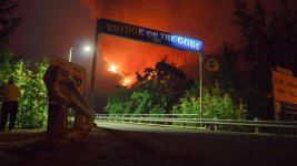
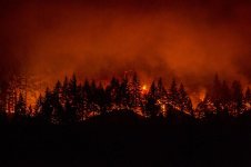
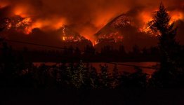
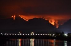
Eagle Creek, Multnomah Falls on Fire

How incredibly sad. The gorge is considered to be one of the most beautiful, scenic areas in the world. Folks travel from across the country and beyond just to come here and catch a glimpse of this breathtaking wilderness. My family and I have spent many years hiking in the beautiful area we call home.

And now, it's in flames. This disaster, set by two irresponsible teenagers tossing firecrackers over a cliff. My heart is broken.

The triangular sign you see in this photo is for the Pacific Crest Trail. This view is from SR 14 on the Washington side looking across to the Oregon side. This is where the WABDR begins.

The following photos are NOT mine.
 

Attachments

  • Eagle Creek 1.jpg
    Eagle Creek 1.jpg
    69.2 KB · Views: 179
  • Eagle Creek 2.jpg
    Eagle Creek 2.jpg
    52.3 KB · Views: 184
  • Eagle Creek 3.jpg
    Eagle Creek 3.jpg
    41.4 KB · Views: 180
  • Eagle Creek 4.jpg
    Eagle Creek 4.jpg
    84.6 KB · Views: 178
Incredibly sad it will takes YEARS for everything to regrow. We were lucky and did sections 1 & 2 during the last week of July.
 

Members online

Forum statistics

Threads
278,317
Messages
3,554,128
Members
248,016
Latest member
Advally Service

Trending content

Back
Top