Death Valley, Furnace Creek, Hole-in-the-Wall

dcampen

New member
In a few weeks I will be going out to Death Valley, near Furnace Creek and then off road to a place called Hole-in-the-Wall and then on farther from Hole-in-the-Wall into the Funeral Mountains.
Anyone been there before?
 
Register to hide this ad
nope. when ya going exactly? I wouldn't mind checking out Death Valley though ;)

If you're thinking about a mini run, visit yotatech.com and check out their proposed yotatech jambo in mar 20-22. We have yet to finalize on a set location but right now it's pretty much between SD and AZ.
 
Hole in the Wall

We are going to camp at Hole-in-the-Wall the first night and the next day continue on to a place they are calling Widowmaker Canyon. I have not found Widowmaker Canyon on any maps but its coordinates are UTM 11 S 526702E 4032671N (Lat/Lon N36.43889 W116.70207).

Is gasoline available at Furnace Creek?
 
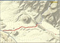
I cant find any mention of "WidowMaker Canyon" in any of my books or maps,so it may be an unofficial name. The location you mention is about 2.6 miles up a wash, from the so called Hole-in-the-Wall, which is really gap in the mountain range caused by water erosion. Dosent look like there is any trail to that location. The hike will gain about 2000ft in elevation. The 4x4 trail ended(closed by park) at a quarry about 2 miles from the gap.
Sounds like you have never been to DV. You will have to check in at the Visitor Center and pay the $10 entrance fee. If desired, the Rangers will talk with you about where you are going and one may be familiar with the location. Once you leave the Center there is a Chevron station, but dont think it is open 24 hours. It has gasoline,diesel, and bulk ice. Down the road is the Furnace Creek Ranch with store, restaurants ,bar etc.
The sign post is on the East side of road about halfway between entrance and exit (west side) of the "Twenty Mule Team Canyon" one way loop. Its worth the time to drive it . The trail is really a wash. Last time I was on it was end of November, and there have been several rains/floods since then. High clearance was needed and 4WD is strongly advisable. You cannot camp within 2mi of the main road turn-off so the gap area would probably be the best spot , about 3.6 mi. That is also the spot where you follow the wash up to "Widow". Area is patrolled by Rangers in vehicles and in the air on a regular basis.
If you want I can send a higher quality Topo image to you. Enjoy and please post an update of trip when you return.
Tom

 

Attachments

  • widowmaker2.jpg
    widowmaker2.jpg
    124.5 KB · Views: 2,148
Nice topo map!

Thanks for the topo map. I have Garmin Mapsource but the map that you posted is even better. What was the source and scale for the map that you posted?

One of the fellows that I am going with who, presumably, has been there before seems to think that we will be able to drive on from Hole-in-the-Wall for a ways before we have to get out and start hiking. I will be carrying 40+ pounds of gear so the closer we can drive the happier I will be.
 
Last weekend.

I went there last weeekend. From Pasadena I drove through Palmdale/Lancaster, Mojave, Ridgecrest and Trona finally following Wildrose Highway out of Trona and over Emmigrant Pass into the North end of DV. Going over Emmigrant Pass I ran into a sleet storm at about 4000 ft. and was regretting that I didn't bring tire chains but the sleet was melting quickly on the road so I didn't have any problems. It took close to 6 hours from Pasadena to the turn off to Hole-in-the-Wall.

When I left on Sunday evening I paid the highest price I have ever paid for gas - $2.62/gallon for 87 octane at Furnace Creek. During the daytime you can get gas in Stovepipe Wells, about 30 mils North of Furnace Creek, for about $0.50/gallon cheaper but the Stovepipe Wells gas station is closed by early evening while the Furnace Creek station seems to dispense gas at any hour if you have a credit card.

When I arrived late Friday afternoon I headed up to Hole-in-the-Wall. Just before dark I found the person I was to meet parked just before the hole in the wall and we proceded on a little past the hole to get a camping spot a little better out of the potential flood plain. The road to Hole-in-the-Wall can be navigated by 2WD or even low clearance vehicles if they are very careful, I even saw a sedan or two on this road as I was leaving on Saturday. I wouldn't take a sedan that I owned on this road though. Friday night I pulled my stuff out of the back of the truck and slept in the truck, there was frost on the windows of my truck and the stuff that I had left outside when I got up on Saturday morning.

On Saturday morning we left my partners truck at Hole-in-the-Wall and took my truck 10 miles up the Echo Canyon trail. The Echo Canyon trail is a bit rougher with sections of deep, soft sand and gravel and high clearance obsticals. It took me about an hour to travel 10 miles up the Echo canyon trail. I definitely put a few scrapes on the skidplates of my truck. We parked my truck on the side of the trail and then hiked 5 miles with a 1000 ft. elevation gain through the desert, rappelled a 600 ft. cliff and hiked another 3 miles back to my partners truck at Hole-in-the-Wall. We took my partners truck from Hole-in-the-Wall, had dinner at a decent coffee shop in Furnace Creek and drove back out Echo Canyon trail to camp Saturday night where I had left my truck.

Sunday we hiked back to the cliff and my partner rappelled to the bottom again. I dropped the ropes to him at the bottom and he began hiking out towards Hole-in-the-Wall while I hiked back to our trucks at Echo Canyon to get my truck and meet him at Hole-in-the-Wall. By the time I had gottten back to my truck and driven the 10 miles out the Echo Canyon trail he was already waiting for me at the head of the hole-in-the-Wall trail. We had dinner again in Furnace Creek and I took him back to his truck up the Echo Canyon trail.
 

Members online

Forum statistics

Threads
278,317
Messages
3,554,128
Members
248,016
Latest member
Advally Service

Trending content

Back
Top