Last Minute Advice(Anza-Borrego)

CenCalTrail

New member
Feel free to move this if i posted in the wrong section.

Im taking the Family out for a last minute 3-day weekend camping trip down to Anza-Borrego in Southern California. Never been there and never looked into it so I'm asking for some help. What are the must see's (i know wildflowers are starting to bloom)? any advice on where to stay? and most important, what are the best trails? Any and all advice is greatly appreciated.
 
Register to hide this ad
I went on split mountain trail, it was beautiful. I wanted to see the mud caves but we were in a hurry, didn't have time.
 
Anza Borrego camping

Anza Borrego is one of my favorite places. Stop in at the Park Visitor's Center at the east, top end of Borrego Springs and pick up a good map and a book of hiking trails. I have several from there. Go online and search the Park website for a map of the roads.
Go to Desert USA online for a wildflower report.
My favorite is Coyote Canyon, an easy drive to the end and then up to Sheep Canyon. There are a couple of stream crossings. Last year the deep one was dry. It runs through a patch of willows. If it looks deep, take off your shoes and walk it first. Should be knee deep or so. Past that it's a very rugged road up a ravine full of rocks. Lots of fun if you take it slow and easy. You must have 4 wheel drive to make it up there. Once through the ravine drive another few miles on a sandy road to the end of the road at Sheep Canyon. You need a map as the road splits twice past the ravine. There are some signs that may direct you. Once you reach Sheep Canyon look for a primitive campsite. Two outhouses located near one site. Bring your firewood, no collecting wood. Bring a table, only two sites have big concrete tables. The attraction is hiking up the canyon to a stream. It get's rugged after the first mile but the beginning is very beautiful. Another easier hike is Cougar Canyon from the same camping area. You need a map and trail description. There's a stream there too.
See my photos of Sheep Canyon and Cougar Canyon at
https://whaleshark.smugmug.com/Landscapes/Anza-Borrego-Desert/
 
Hope this helps... Just make sure you get there during the day time and not do a stupid move like me and camp in the wash lol

http://www.toyota-4runner.org/2039166-post180.html

http://www.toyota-4runner.org/2039170-post181.html

p1234981807-4.jpg
 
First off when are you going? Tierra del so is this weekend if you're interested, and would be a great first time trip. Lots of vendors and some fun wheelin. Just stay out of the notches at night if you dont like crazy. Im from borrego and it still a good place to get out and camp. Check out the calcite mines out of s22, fun little few hr trip. Check out truck haven just a few miles down the road, lots of trails in and around Ocotillo wells that are easy to use and make getting around that side of the park easy. Check out coyote canyon up into sheep canyon, decent little secluded place to camp up at the mountain base. Hit carlees for some good grub and a cold one or 6....

Sent from my SM-T330NU using Tapatalk
 
If you're coming up from Interstate 8 through Ocotillo, take S2 to Canyon Sin Nombre. Take that trail down through the canyon and into the heart of the Carrizo Badlands. You'll come to the big dry wash at the center of the badlands. From there you can go west and take one of several trails into the north side of the badlands, such as Arroyo Seco del Diablo, or Arroyo Tapiado. Or you can keep going west until you get back to S2.

Way back up in Arroyo Seco is a place called the Drop Off, where you can take a steep drive down into Fish Creek Wash. Here you can go up the wash to places such as Sandstone Canyon, or you can go down the wash through Split Mountain and come out at Ocotillo Wells. From there you can go to Borrego Springs or west up the mountains to Julian.
 
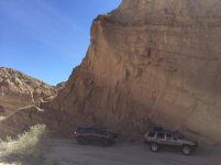
I second fish creek wash, it's a gorgeous winding trail with tall cliffs on both sides. You can get here a couple ways. 78->Split Mountain Rd(Perpendicular to the airport)->Fish Creek or from the south, S2, where multiple trails converge to this location. You can also find the wind caves here and other hiking trails. I also agree with Coyote Canyon, but I'm sure about the condition of this trail dude to the amount of rain we just received. I believe there are 3 creek crossings. I don't know the depth of water at this point, but that would probably be the best place to see the wild flowers. The pic below is of fish creek wash last weekend before the rain.
 

Attachments

  • IMG_6093.jpg
    IMG_6093.jpg
    130.6 KB · Views: 1,242
A lot of good areas have already been mentioned. If you're looking for family friendly, one thing to consider is bathrooms are only available in a few places in the park if you're not near Borrego Springs. Culp Valley has one, Blair Valley, and Sheep Canyon. Not sure where else has one off the top of my head, especially on the south end of the park off the S2. Just something to consider.

Also, if you do plan on heading to the south end, just keep in mind that there are no gas stations in the area. If you do the mud cave off Arroyo Tapaido, not a problem. If you continue on through Diablo Dropoff through Fish Creek/ Split Mountain, make sure you gas up or bring some extra fuel.

Have fun and post pics when you come back!
 
:)

This site ---> Anza Borrego Desert State Park - Wildflower Reports - DesertUSA

It's constantly updated with reports on the desert flower bloom I'm AnzaB, including basic highlighted maps.

I recommend you run this trail first, starting at the 78 and Julian. I liked Chariot Canyon.


Suggested start: Julian Gas Station

Trip Pics: ---> http://www.toyota-4runner.org/off-roading/230780-trails-near-julian-socal.html


Anza-Borrego GPS Nav Points - Works with any iPhone / Android GPS App
----> https://drive.google.com/file/d/0BzWSba3crqAkRU9OYV90dW5BbjQ/edit?usp=sharing


Official Park Map Download PDF ----> http://www.parks.ca.gov/pages/638/files/abdspmap.pdf
(Don't be the dude who has no idea where they are)


Trail Head: We exited the 78 at Banner Rd. That is the beginning of a trail that connects to Charriot Canyon trail and also Rodriguez Trail. I've now gone down both and can advise forking to the right and taking Chariot Canyon trail because it is more scenic. The total trial from the 78 back down to the HWY in the dessert is about 1.5 hours.


Planning Thread: http://www.toyota-4runner.org/so-cal/162537-sunday-2-23-south-anza-borrego-day-trip-planning.html

I'll be there next weekend, starting off in the hills of Julian and cruising down into Anza-B.

I believe the washes and canyons will have very little flowers, you will see more by sticking to the areas posted on that website.

If your family is with you I suggest doing Chariot Mine (assuming you are decent with GPS maps and won't get lost), then once you hit pavement 1.5 hrs later, head over to the visitors center, then fonts point, then drive around and see the flowers and metal sculptures along the roads.

You could spend half a day in the washes and canyons but you won't really have time to do all of this in one day. The visitors center will be packed. I always bring lunch. You will save a lot of time if you already have maps, GPS and plans for where to visit before getting into the park.

One more thing, if you drive out towards the railroad tracks to the south, stay out of the deep dust & mud pits. Drive around. Whatever you do, don't drive in that crap. The fine silt is bad for your engine and when muddy it can be 3+ feet deep.
 
Last edited:
So Cal off-roading forum

Thanks for moving this thread to yet another location (moved twice). I wouldn't have known this forum existed if it hadn't been moved here. If I can find this forum again in this maze of links, I'll be sure to return when I'm making plans to off road in So Cal. This is a good source for finding trips in So Cal.
 
Thanks for moving this thread to yet another location (moved twice). I wouldn't have known this forum existed if it hadn't been moved here. If I can find this forum again in this maze of links, I'll be sure to return when I'm making plans to off road in So Cal. This is a good source for finding trips in So Cal.

Bookmark the SoCal section or go to the top of the page click on forum jump>so cal .very easy to find that way.
 

Members online

Forum statistics

Threads
278,315
Messages
3,554,104
Members
248,016
Latest member
Advally Service

Trending content

Back
Top