Your fave GPS app for iPhone?

jjdbike

New member
Hello everyone and happy Memorial Day.

Thank you to everyone who served.

My GPS died. Now that we have smart phones it seems silly to replace it w/ a GPS.

What is your favorite GPS app for iPhones? It would need it to show current speed and need it to link through Blue Tooth to my radio so I could hear it speak turns etc. It would be cool to be able to drop pins to mark fishing spots. It would also be cool if it worked off road too (I don’t know if any do that).

Currently I use the one that my iPhone defaults to from my contact list. Honestly that is a pretty cool feature & that GPS app is ok. On the other hand I am guessing there are better dedicated GPS apps out there though.

What do you guys use?

Thanks!
JD
 
Register to hide this ad
Hello everyone and happy Memorial Day.

Thank you to everyone who served.

My GPS died. Now that we have smart phones it seems silly to replace it w/ a GPS.

What is your favorite GPS app for iPhones? It would need it to show current speed and need it to link through Blue Tooth to my radio so I could hear it speak turns etc. It would be cool to be able to drop pins to mark fishing spots. It would also be cool if it worked off road too (I don’t know if any do that).

Currently I use the one that my iPhone defaults to from my contact list. Honestly that is a pretty cool feature & that GPS app is ok. On the other hand I am guessing there are better dedicated GPS apps out there though.

What do you guys use?

Thanks!
JD

It doesn't show speed (that I'm aware of) and I'm sure there are more off-road centered apps that are better for that sort of thing. But for everything else you mentioned I haven't found anything that works better or more consistently than Google Maps when traveling or even just around towns.

It is a definite improvement compared to the Apple Maps it sounds like you're using.
 
Last edited:
On my iPhone, I've consistently determined the Apple map/GPS ap is inaccurate, incomplete and poor. (Other than that I like it)

I use Google Maps. It integrates with my Bluetooth, seems to maintain an updated content and is accurate.

I've also downloaded a speedometer ap. I got a free one that appears to correlate reasonably closely to my real speedometer. There were a bunch available but I didn't try them as this one serves the purpose.

I link my Google map destination to BT, the open the speedo ap and set the phone face up so I can read the digital display. It also has time elapsed, etc., should I be interested.

Hope this is useful.
 
You'd get much wider audience if [MENTION=66316]1engineer[/MENTION] moved this to the General Discussions section.
 
On my iPhone, I've consistently determined the Apple map/GPS ap is inaccurate, incomplete and poor. (Other than that I like it)

I use Google Maps. It integrates with my Bluetooth, seems to maintain an updated content and is accurate.

I've also downloaded a speedometer ap. I got a free one that appears to correlate reasonably closely to my real speedometer. There were a bunch available but I didn't try them as this one serves the purpose.

I link my Google map destination to BT, the open the speedo ap and set the phone face up so I can read the digital display. It also has time elapsed, etc., should I be interested.

Hope this is useful.

Yes very thanks!
JD
 
For road trips where I'll be using interstates, I really like Waze because it redirects you around traffic, alerts you of police, and has a built in speedometer. For general everyday navigation I like Google Maps.
 
Moved to appropriate section. OP, this sub forum is for 5th gen 4Runner specific stuff. Apps and such are not vehicle specific unless it is an Entune app.
 
amother plus for google maps is that in the settings you can make it respond like a Bluetooth call so that it will still chime in turn directions even if you're listening to the radio.

My wife loves waze too
 
Gaia GPS for the iphone is by far the most accurate and easiest to use. its as good as any Garmin you can get. Also going to need the Offline Topo Map app as well.
 
Google Maps over here - too. Seems to get better and better with time.

And now that Google owns Waze (2 years now?) - they integrate some of that special sauce and of course pool all of the realtime user data to end up with a huge amount of live info regarding traffic and realtime conditions. That free app and an iPhone/Android is so much better than my $1200 Alpine HU GPS (that also has FM Traffic - what a joke)!!!! Not even close...

PS - Google Maps can use offline areas in poor connectivity conditions - but the offline areas must be defined and downloaded preemptively. Pretty cool - I have my main 3 destinations all saved as offline areas - covers a good chunk of the city...

:cool:
 
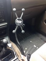
Look into bad elf, it's a unit you plug into the iPhone/pad and it turns said device into a gps. I'm still messing around with it, but it's great for when you are out of service and using a map that you down loaded. I'm in a 3rd gen so I know it won't be the same but I mounted this ram mount setup to hold my iPad so I can have a large screen to glance at while driving.
 

Attachments

  • image.jpg
    image.jpg
    125.7 KB · Views: 299
amother plus for google maps is that in the settings you can make it respond like a Bluetooth call so that it will still chime in turn directions even if you're listening to the radio.

My wife loves waze too


How did you get it to play over the stereo? I can only get it to read directions when I'm playing music from my phone over the bluetooth. If listening to the AM/FM I get nothing.
 
How did you get it to play over the stereo? I can only get it to read directions when I'm playing music from my phone over the bluetooth. If listening to the AM/FM I get nothing.

Settings-Nav Settings-play as blue tooth call. It will be normal when you're streaming music from your phone. But when you have another source selected it will interrupt what you're listening to and essentially call the car, auto answer and say the directions and then auto hang up. So it takes a second longer. It's also pretty annoying if you're listening to NPR.
 
Should also mention In addition to being free, consistent, and constantly up-to-date. Google maps also handles public transportation in big cities very well if you ever have a need. My wife and I visited Portland last year, had no rental car, and it was a lifesaver. We got to do so much more than we otherwise could have just being able to get around efficiently cos it knew where every bus/trolley/train were at at all times. There are obvious benefits to having "downloaded" maps that don't require data usage. But the benefits of being able to tap into google's database at a moments notice is huge when it comes to shifting routes based on traffic.
 

Members online

Forum statistics

Threads
278,312
Messages
3,554,085
Members
248,016
Latest member
Advally Service

Trending content

Back
Top