
December Run: 12/5 Silverado Truck Trail to Hell's Kitchen

ElGringoLoco

New member
Edit: Date is 12/15

Edit: Just got word this morning that I'll be needed at work Saturday morning- so we're going to have to scrub it. Sorry dudes.
 
Last edited:
Register to hide this ad
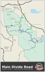
Alright, here's a map of the route in blue. The green trails represent ways off the trail if you don't want to do the whole thing. The blue star is our meeting point, at the trailhead. Solid lines equal pavement, and the dashed lines obviously are dirt. Again, it's a pretty basic and very scenic run. There are photo ops everywhere and the elevation changes make it even more fun.
 

Attachments

  • 12-15 Trail Map.jpg
    12-15 Trail Map.jpg
    165.6 KB · Views: 466
Awesome.
I actually just went up there this past weekend. I just went from Silverado Canyon road up to the peak and back. I haven't been on the South leg towards Ortega though, so that will be new to me.

Unless something comes up, count me in.
 
Count me in for this. Its a lot closer then azusa canyon. Didn't see this until you said something in the other thread.
 
I may be in for this run depending if I decide to snowboard. You may want to contact forest service as the last time we tried entering Main Divide from the 74 the gate was closed. We ended up going up Bedford Cyn down to Maple Springs Rd. Fun, easy run but there are a few 4WD lines.
 
Alright, let's get a headcount going. We don't want to leave anyone behind. If you're a maybe, just put maybe next to your name:

1. ElGringoLoco y La Gringa Loca
2.
3.
4.
 
So this is taking the trail from roughly West to East? Silverado Canyon to Santiago Peak, to the Ortega Hwy?

If I am free on the 15th, I will go as well.
 

Members online

Forum statistics

Threads
278,316
Messages
3,554,120
Members
248,016
Latest member
Advally Service

Trending content

Back
Top