Eastern Sierra day drives

Enjoy your trip OP.
I would NOT recommend camping with a 3MO. Went camping with a 1 year old and that was challenging enough.

I like this thread and have been thinking of starting a Camping/Wheeling where to go thread.

What you guys think?

Hey Danny! That's why we're hoteling it this time. I'm sure I'll see a zillion places I'd love to return to and camp at. I'll let you know how it is and what I do.

Don't mind this thread being jacked some in the name of Sierra Nevada sight seeing and wheeling!

Tim
 
1. Ancient Bristlecone Pine forest in the White Mountains. Beautiful drive to the oldest trees in the world. Take Hwy 395 north from Lone Pine to the town of Big Pine. At the north end of Big PineTurn right on Hwy 168, you'll see the sign. You'll love the drive.

2. Alabama Hills/Movie Road--Whitney Portal Rd west from Lone Pine approximately 3 miles to Movie Rd in the Alabama Hills. Hundreds of movies and commercials have been filmed in the Alabama Hills. Movie rd. turns into a well-graded dirt road after about 1/2 mile but you can follow it for about 10 miles through the Alabama Hills--it will take you right back to HWY 95 at the north end of Lone Pine. Alabama Hills are a great place to camp and hike too.

2. Tuttle Creek Road Drive/Horseshoe Meadow Drive--While you're in Lone Pine you should take a drive up Tuttle Creek Road. From Lone Pine take the Whitney Portal Rd. west approximately 1/2 mile. Turn leftt on Tuttle Creek Road. It's a short but gorgeous drive--about 3 1/2 miles one way. Be careful though--it's one lane all the way. When you get to the top of Tuttle Creek Road, keep heading south til the road dead ends. Turn right (East) on Lubken Canyon Rd. Then turn left on Horseshoe Meadow Rd. If the road isn't closed (for the winter) past the Lavender farm you are in for one beautiful 20 mile drive up to 10,000 elevation. Get your camera out.

3. Bishop Creek Rd.--You know where this is if you've been to North and South Lakes, but did you know both the south and north fork of Bishop Creek Road are stunning Fall drives?

4. Death Valley (it turns into Hwy 190 after about 14 miles) from Lone Pine to Furnace Creek Ranch, Death Valley, CA. Fabulous drive but over 100 miles long one way. Cut it short and turn around at Stovepipe Wells if you want. Or sooner. If you have time, go take a walk on the Mesquite Dunes near Stovepipe Wells. At night. Your whole family will love that. You've never seen so many stars. You shouldn't have to worry about the Park being closed--for the drive, at least-- because there's no entrance stations and many residents in the surrounding areas commute through the park on a daily basis. So highway 190 should be open through the park.

5. Mono Lake--The Mono Lake Visitor Center is at the north end of the town of Lee Vining off HWY 95 (this is north of the entrance to Yosemite which is just to the south of Lee Vining). The visitor center will likely be closed but you can still walk or drive around the lake. Check out the Tufa towers. If the visitor center is closed, you can get all the info you need about Mono Lake in Lee Vining.

Well, that should help you out a little.
 
Last edited:
1. Ancient Bristlecone Pine forest in the White Mountains. Beautiful drive to the oldest trees in the world. Take Hwy 395 north from Lone Pine to the town of Big Pine. At the north end of Big PineTurn right on Hwy 168, you'll see the sign. You'll love the drive.
Haven't been there, most likely on our list.

2. Alabama Hills/Movie Road--Whitney Portal Rd west from Lone Pine approximately 3 miles to Movie Rd in the Alabama Hills. Hundreds of movies and commercials have been filmed in the Alabama Hills. Movie rd. turns into a well-graded dirt road after about 1/2 mile but you can follow it for about 10 miles through the Alabama Hills--it will take you right back to HWY 95 at the north end of Lone Pine. Alabama Hills are a great place to camp and hike too.
Been there, love it. Probably stopping over there again.

2. Tuttle Creek Road Drive/Horseshoe Meadow Drive--While you're in Lone Pine you should take a drive up Tuttle Creek Road. From Lone Pine take the Whitney Portal Rd. west approximately 1/2 mile. Turn leftt on Tuttle Creek Road. It's a short but gorgeous drive--about 3 1/2 miles one way. Be careful though--it's one lane all the way. When you get to the top of Tuttle Creek Road, keep heading south til the road dead ends. Turn right (East) on Lubken Canyon Rd. Then turn left on Horseshoe Meadow Rd. If the road isn't closed (for the winter) past the Lavender farm you are in for one beautiful 20 mile drive up to 10,000 elevation. Get your camera out.
Haven't done it, sounds cool, will add it to the ideas bucket.

3. Bishop Creek Rd.--You know where this is if you've been to North and South Lakes, but did you know both the south and north fork of Bishop Creek Road are stunning Fall drives?
Will probably be back here again and yeah it is spectacular. The only other time I have been there it was fall and the colors were awesome!

4. Death Valley (it turns into Hwy 190 after about 14 miles) from Lone Pine to Furnace Creek Ranch, Death Valley, CA. Fabulous drive but over 100 miles long one way. Cut it short and turn around at Stovepipe Wells if you want. Or sooner. If you have time, go take a walk on the Mesquite Dunes near Stovepipe Wells. At night. Your whole family will love that. You've never seen so many stars. You shouldn't have to worry about the Park being closed--for the drive, at least-- because there's no entrance stations and many residents in the surrounding areas commute through the park on a daily basis. So highway 190 should be open through the park.
One of my favorite places on earth, but skipping it this trip to let the roads heal (if the gov't gets back to work that is) after all the flash flooding. Planning a large trip there in February (stay tuned for that one).

5. Mono Lake--The Mono Lake Visitor Center is at the north end of the town of Lee Vining off HWY 95 (this is north of the entrance to Yosemite which is just to the south of Lee Vining). The visitor center will likely be closed but you can still walk or drive around the lake. Check out the Tufa towers. If the visitor center is closed, you can get all the info you need about Mono Lake in Lee Vining.
Mono Lake was going to be on our list again as well, really neat place.

Well, that should help you out a little.

Thanks [MENTION=95578]2013Trail[/MENTION] for putting the time into this post! Sounds like you love your Eastern Sierras!
 
You will see a ton of FJ's on 395 but should also see plenty of 5th gens. I guess we prefer the road less traveled.

Anther couple of spots I forgot to mention:

Lundy Lake, West of Mono Lake

Virginia Lakes. Just up past Mono Lake.
 
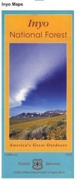
I've got a ton of maps of the area, but the one I picked up most recently at the White Mountain Ranger Station in Bishop is the best one I've seen so far. Shows every campground, secondary road, hiking trail, and almost all 4wds road that I've cross referenced.. very comprehensive. If you're inclined you might want to check it out, I was so impressed with it I thought I'd share. Have a good trip!
 

Attachments

  • Screen Shot 2013-10-03 at 10.12.07 AM.jpg
    Screen Shot 2013-10-03 at 10.12.07 AM.jpg
    22.5 KB · Views: 456
Bodie Ghost Town

Also, don't forget to visit the Bodie Ghost town. You take a state road east off of 395 north of Lee Vining. A very cool place if you're into history.
 
I also strongly recommend you visit the old ghost mining town of Cerro Gordo. It's at about 8900 feet elevation in the Inyo Mountains. Take HWY 136 from Lone Pine for about 14 miles to the town of Keeler. As you near the south end of Keeler be looking for a small green street sign on the left that says "Cerro Gordo Rd." Turn left there and follow the road all the way up to Cerro Gordo. It's a steep winding dirt road and a beautiful drive. If the Visitor Center in Lone Pine is open it's a good idea to stop in there and get the phone number of the caretaker of Cerro Gordo before you drive into the town. He'll come out to meet you, tell you the rules and give you a tour if you want. While you're there you got to go inside the American Hotel, the old bunkhouse--which is supposed to be haunted--and one of the houses is available to tour. Then, you can get back on Cerro Gordo Road, drive east over the mountains and all the way to Hwy 190. From there you can go left to Death Valley or turn right to get back to Lone Pine. You should allow at least four hours if you decide to go over the pass and out the back way as I just described. But it's dirt road all the way. And you should have an OHV map which you can also get free at the Lone Pine Visitor Center.
 
Last edited:
I've got a ton of maps of the area, but the one I picked up most recently at the White Mountain Ranger Station in Bishop is the best one I've seen so far. Shows every campground, secondary road, hiking trail, and almost all 4wds road that I've cross referenced.. very comprehensive. If you're inclined you might want to check it out, I was so impressed with it I thought I'd share. Have a good trip!

Thanks Sparky! I'll have to pick one up! (Always love me some free NFS trail maps, they tend to be better than the $12 Nat Geo ones I always seem to buy lol).
 
Also, don't forget to visit the Bodie Ghost town. You take a state road east off of 395 north of Lee Vining. A very cool place if you're into history.

[MENTION=99803]judex[/MENTION], Bodie is really awesome. Not sure we planned to go there this trip bc we've done it once before, but now were unsure as to the status of just standard Natl Forest roads with the shutdown.

Anyone have any experience (wherever you may be in the US) with Forest closures? No one at the Bishop/Mammoth/Lone Pine visitor centers seems to know. We'd hate to drive up just to enjoy the Mammoth shopping scene!

Tim

ps- GO DODGERS!
 
I also strongly recommend you visit the old ghost mining town of Cerro Gordo. It's at about 8900 feet elevation in the Inyo Mountains. Take HWY 136 from Lone Pine for about 14 miles to the town of Keeler. As you near the south end of Keeler be looking for a small green street sign on the left that says "Cerro Gordo Rd." Turn left there and follow the road all the way up to Cerro Gordo. It's a steep winding dirt road and a beautiful drive. If the Visitor Center in Lone Pine is open it's a good idea to stop in there and get the phone number of the caretaker of Cerro Gordo before you drive into the town. He'll come out to meet you, tell you the rules and give you a tour if you want. While you're there you got to go inside the American Hotel, the old bunkhouse--which is supposed to be haunted--and one of the houses is available to tour. Then, you can get back on Cerro Gordo Road, drive east over the mountains and all the way to Hwy 190. From there you can go left to Death Valley or turn right to get back to Lone Pine. You should allow at least four hours if you decide to go over the pass and out the back way as I just described. But it's dirt road all the way. And you should have an OHV map which you can also get free at the Lone Pine Visitor Center.

Sounds neat! I'm gonna check that out!
 
Tungsten Hills near Bishop

A fun place to 4 wheel really close to Bishop. Lots of mines and cool areas to explore.

The whole Eastern Sierra is a undiscovered wonderland for outdoors fun. I can't wait to go back!
 

Attachments

  • photo5.jpg
    photo5.jpg
    53.3 KB · Views: 546
  • photo6.jpg
    photo6.jpg
    48.4 KB · Views: 536
Thanks Sparky! I'll have to pick one up! (Always love me some free NFS trail maps, they tend to be better than the $12 Nat Geo ones I always seem to buy lol).

Oh yea, the NatGeo "topo's" are kind of a joke compared to USGS. This Inyo map wasn't free though, I believed I paid $10 for it. It's worth checking out though.
 
We need to do a T4R meet in Mammoth...

In the winter, I am always parked @ the Mill most weekends...

Now that's a meet I can actually make verse the east coast meets. Only just shy of a 5 hour drive for me. Hmm. Time to start thinking of possible weekends and routes before snow season hits.
 
Oh yea, the NatGeo "topo's" are kind of a joke compared to USGS. This Inyo map wasn't free though, I believed I paid $10 for it. It's worth checking out though.

You can get free OHV maps at the Lone Pine Visitor Center. There are two different ones. The gold one is for the Bishop and surrounding area. The pink one is for the Inyos and south.
 
You can get free OHV maps at the Lone Pine Visitor Center. There are two different ones. The gold one is for the Bishop and surrounding area. The pink one is for the Inyos and south.

That is one of the best visitors centers I've ever been to so we'll likely be stopping by there again, I'll see what I can pick up :)
 
We need to do a T4R meet in Mammoth...

In the winter, I am always parked @ the Mill most weekends...

This!

Would be fun to meet up and wheel with any and all possible T4R guys (heck I'm open to all Toyota truck/4wd guys).

I'm planning a Death Valley trip for February likely around Valentine's weekend. If my passengers are up for it I think that would be an awese meeting place. Infinite wheeling out there. So many trails I want to do and they're always better in groups!

Tim
 
Now that's a meet I can actually make verse the east coast meets. Only just shy of a 5 hour drive for me. Hmm. Time to start thinking of possible weekends and routes before snow season hits.

It's 5 1/2 hours door-to-door for me one way. I actually think 40K of my 60K odometer reading is just related to doing this drive...lol.

BTW - Mammoth opens Nov. 7th!!! Pray for snow.:smow:
 
It's 5 1/2 hours door-to-door for me one way. I actually think 40K of my 60K odometer reading is just related to doing this drive...lol.

BTW - Mammoth opens Nov. 7th!!! Pray for snow.:smow:

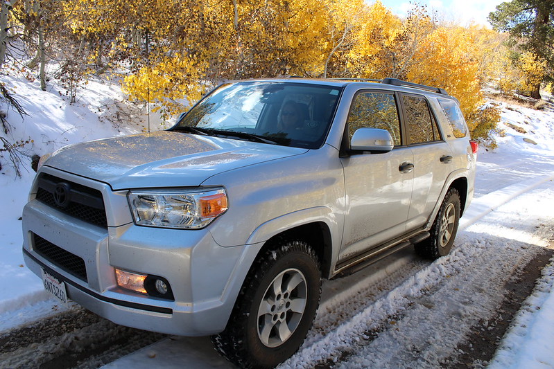
Oh there was snow alright! We got like 3 inches in Mammoth on Wednesday, this


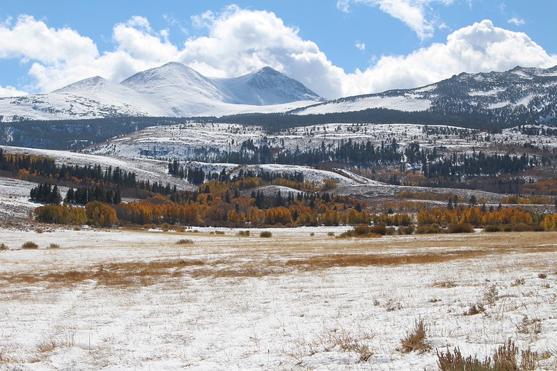
was from Dunderberg Road (south of Bridgeport, road comes out at Virginia Lakes north of Lee Vining) on Thursday! (My Mom staring at the camera lol).

Lots of sloshy sometimes muddy snow to romp through, not to mention lots of awesome fall color interspersed like ribbons through the mountains and pine trees!


The little man being cold atop the Ancient Bristlecone Pine Forest some 9,000 feet above sea level in the White Mtns (cold and windy this Tuesday).


As for the rest, Flickr is having a helluva time uploading pictures right now so not a lot of pics from the rest of the trip but I will give everyone a 411 of what we did and saw in another post.

Had a blast though!
Tim
 
Last edited:

Members online

Forum statistics

Threads
278,316
Messages
3,554,110
Members
248,016
Latest member
Advally Service

Trending content

Back
Top