First trip to Moab

RockyMtnYota

New member
Hi guys, I'm trying to plan a trip to moab around the beginning of April. I've never been but have read some about the area and trails. What is the weather like this time of year? Snow? Any recommendations for easy trails? We have a 6mo old with us so would need to be pretty tame. Any recommendations for hotel/motels in the area? I am aware of traildamage.com and I believe they have some pretty detailed trail info for difficulty.

Thanks for the feedback.
 
Register to hide this ad
The weather will probably be really good, but snow and cold nights are a possibility. You'll be coming in just before Easter Jeep Safari, so expect hotels to be full, and expensive.

Order up a copy of Charlie Wells Guide to Moab, anything on his "Easy" list and most of the "Moderate" list will be no problem for a stock 4Runner.
 
:iagree: Expect cold nights, possibly dipping below freezing, but warming up very quickly during the day. This is the time of the year where you will use both heat and A/C!

Nice thing about Moab is that some of the "easy" trails are also the most scenic. Potash Road will take you out of Moab and runs along the Colorado River where you can either turn off at Long Canyon or continue on until you hit the beginning of White Rim Trail.

At White Rim you can either drive down until you feel like turning around, or you can take a right and go up the Shaffer Trail switchbacks to the top of the plateau for some awesome views.

White Rim Trail is 100 miles long, I wouldn't try to do it in a day (although many people do, IMO it doesn't give you time to really enjoy it.) Sounds like you aren't camping so if I was you, I'd probably just go down White Rim a few miles to some of the great overlooks and then turn around and go back up to the top of Island in the Sky. There are lots of paved roads up there that lead to awesome views as well. You could also hit Gemini Bridges, another easy trail with great views.

I'll also second the Charles Wells book. It's a great, handy little guidebook to have.

In truth, there's not a "bad" time to be in Moab, but IMO Spring and Fall are the best time to be there!

 
I would love to do a moab trip buts not that close for me! plan on doing one this summer maybe and going to do the rubicon in 2 weeks!
 
I'm going to be in Moab from 3/30-4/2. I plan to ride Porcupine Rim on the MTB and drive the 4Runner on Fins 'n' Things and Elephant Hill. I'll be there with a couple buddies (a disco and a Dodge pickup) and our S.O.'s. Maybe we'll run into each other, figuratively if not literally. :)
 
:iagree: Expect cold nights, possibly dipping below freezing, but warming up very quickly during the day. This is the time of the year where you will use both heat and A/C!

Nice thing about Moab is that some of the "easy" trails are also the most scenic. Potash Road will take you out of Moab and runs along the Colorado River where you can either turn off at Long Canyon or continue on until you hit the beginning of White Rim Trail.

At White Rim you can either drive down until you feel like turning around, or you can take a right and go up the Shaffer Trail switchbacks to the top of the plateau for some awesome views.

White Rim Trail is 100 miles long, I wouldn't try to do it in a day (although many people do, IMO it doesn't give you time to really enjoy it.) Sounds like you aren't camping so if I was you, I'd probably just go down White Rim a few miles to some of the great overlooks and then turn around and go back up to the top of Island in the Sky. There are lots of paved roads up there that lead to awesome views as well. You could also hit Gemini Bridges, another easy trail with great views.

I'll also second the Charles Wells book. It's a great, handy little guidebook to have.

In truth, there's not a "bad" time to be in Moab, but IMO Spring and Fall are the best time to be there!

Exactly what I was looking for! Thank you sir on the trail advice!
 
You might want to have a PLAN B just in case......the Rubicon is presently :closed_2:

I don't know where you enter the trail from but the trail is currently closed if you enter from tahoe, but if you enter the old fashion way either the gate keep or through loon lake there is access to the trail 24/7/365 the rubicon is never closed my friend they don't allow you to enter from the tahoe side aka closed because of snow I am local from placerville had some buddies go up 2days ago from the gate keeper!!!! We went up for an overnighter day after christmas don't know where you get your info from but Im local El Dorado County Boy and the rubicon is in my back yard shit aint closed! Ill post pics in two weeks!:artist2::hand::rofl::eyebrows::redbrick:
 
http://https://www.edcgov.us/Goverment.aspx?id=2147485133

I guess your more local than the people who administer the trail. Did you happen to keep abreast of any of the land access meetings regarding the Rubicon this last year? Does "attachment C" sound familiar at all? 3 page thread over on Pirates about the closure with quite a few local users pissed about it. The environmental do gooders have got a solid foot in the door , now wait for expansion. :doh:
 
http://https://www.edcgov.us/Goverment.aspx?id=2147485133

I guess your more local than the people who administer the trail. Did you happen to keep abreast of any of the land access meetings regarding the Rubicon this last year? Does "attachment C" sound familiar at all? 3 page thread over on Pirates about the closure with quite a few local users pissed about it. The environmental do gooders have got a solid foot in the door , now wait for expansion. :doh:

I don't know where you get your info man but you need to cross reference your info because your sounding exceptionally ignorant down their in sunny Santa Barbara...****in' flatlanders :humble::sniper:

cause some of the homies were out there last weekend SMH


all these photo's were taken on a pass done last week entering at Loon Lake going all the way to Buck Island :bluejump::withstupid:

ya understand?
 
Last edited:
unlimitedfj4- that,s some good stuff right there, good to see it. I,ll admit to ignorance being way down south, but I am not really a Flatlander, I'm from Tahoe. I wonder what ElDorado County Forest Service is doing with posting that Closure notice and stirring up the natives though? Anyways, glad to see you have boots on the ground and the greenies haven't shut us out yet :tape:
 
From the ElDorado County Gov site-

"The Transportation Division maintenance crews completed a monitoring site visit of the Rubicon Trail on March 11, 2014. Based on observational data obtained during the visit, the County determined that the temporary closure of the Rubicon Trail initiated on February 25th, 2014 can be lifted. Please be advised that, should conditions change, the temporary closure may be put back in place. Please check back to the County website for updates relative to future temporary closures of the Trail.

":wtf:
 
From the ElDorado County Gov site-

"The Transportation Division maintenance crews completed a monitoring site visit of the Rubicon Trail on March 11, 2014. Based on observational data obtained during the visit, the County determined that the temporary closure of the Rubicon Trail initiated on February 25th, 2014 can be lifted. Please be advised that, should conditions change, the temporary closure may be put back in place. Please check back to the County website for updates relative to future temporary closures of the Trail.

":wtf:

I don't know how long you lived in El Dorado County, or what time period you lived here. But I have lived here since early 2003 and I have to say it is one of the most corrupt ass backward counties I have every lived in. The court systems, the building and planning department. The El Dorado County Sheriffs I mean literally every branch that is ran by the county is filled with corruption and scandal not to mention the drug epidemic here it's mind blowing. Im kind of embarrassed to be from this area. it's kind of mind blowing the county stays afloat. They seriously can not get anything figured out. Their whole system is screwy. That being said Im shocked they even maintain that website because everything is lost behind or double filled. :der::bash: Im sure the last thing they are worried about is people on the trails having some good old clean fun. I would not trust anything I read on El Dorado County website. Im always checking on platform120 forum and pirate4x4 and seeing what other locals are doing. The county got their head so far up their ass they don't know shit lol. I actually was in Tahoe since friday snowboarding at heavenly with some buddies we decided to go scout the tahoe entrance and it is closed due to snow but should be opening I would say in the next two weeks as the snow melts fast!!!

Also I believe they may be putting that the trail is or was closed on those sites to deter tourist and visitors to the area using the trail. Last summer one of the locals that lives in a cabin just off the trail and actually patrols the trail for a living. Was telling me some of the greener folk the enviormentalist were taking studies on poop left on the trail by humans and they were actually monitoring the amount of people pooping and just leaving it in the trail and it was up to like 10k plus last summer so they were threatening to shut the trail down this year for cleanup of all the human waste. But they monitored through out the late summer and people were actually able to cut back on poop on the trail by bring a portable toilet with them and 6 brand new porter potties were donated to the rubicon foundation last august and were brought in to different location on the trail via locals using their own trailer so with portable toilets and install the porter potties we were able to get the environmentalist off our backs and prevent them from closing the trail for "clean up":sobbing::bash::ban: I also believe that is why on the website they said it was closed to prevent out of towner from coming in for a period of time and keeps its usage alot less limited because people come from all over the world to hit the rubicon! I seen guys up there that bought brand new Jeep Unlimited JKs 4doors on 31s and drove straight from new mexico to the rubicon trail to test out their new purchase they actually went straight to moab and then headed up to the rubicon the rigs didn't even have 5k miles combined and they were wheeling the shit outta both of them gotta love the jeep guys!!:rockthrow:
 
What is the weather like this time of year? Snow?

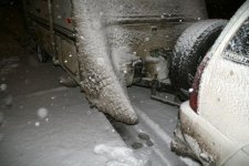
I'll summarize the weather in one pic from last April. We had snow and sun on the trails so overall it was fine. It got cold at night and the drive home was a b*tch. The pic is my trailer after the 11 hour drive home when the high passes were closed by snow.
 

Attachments

  • trailer berg.jpg
    trailer berg.jpg
    48.5 KB · Views: 172
We just got back from Moab and had a blast. We used the FunTrek guide book to do moderate/easy trails to scenic destinations.

Photos here:
2014 Moab Vac - a set on Flickr

Guide book here:


you photography is amazing what camera and lens where you shooting with great job!

did you happen to venture toward the hot tubs or see anyone hitting the hot tubs in moab I alway see the most awesome videos of the moab hot tubs I can't wait to venture out there this summer!
 
you photography is amazing what camera and lens where you shooting with great job!

did you happen to venture toward the hot tubs or see anyone hitting the hot tubs in moab I alway see the most awesome videos of the moab hot tubs I can't wait to venture out there this summer!

No, did not see the hot tubs. Actually had no idea on how to get to those. There weren't a lot of crawler type rigs in Moab, so we didn't bother trying to go watch any of the extreme trails/areas. We were limited on time since we only had 4 days and a number of trails to hit. The trails we did:

Tower Arch (Arches N.P.)
Eye of the Whale Arch (Arches N.P.) and 4x4 road between these 2
Long Canyon Rd and Pucker Pass
Bull Canyon (trail to lower Gemini Bridges)
Gemini Bridges (trail from 191 to 313)
Picture Frame Arch
Baby Lion's Back
Secret Spire
Tom Dellenbaugh Arch/Tunnel

We didn't break anything and never needed recovery. I consider that a success.

My camera gear:
Canon 5D Mk III
Canon 6D
Canon 24-105mm f/4L IS
Canon 24mm f/1.4L II
Canon 14mm f/2.8L
Canon 70-200mm f/2.8L II IS
Canon 16-35mm f/2.8L II
 

Members online

No members online now.

Forum statistics

Threads
278,306
Messages
3,554,045
Members
248,016
Latest member
Advally Service

Trending content

Back
Top