
Garmin Overlander

bring_it_on

New member
Interesting product from Garmin though a bit pricey. Based on Android so I guess it will be smoother and faster to scroll through and type compared to older gen. navigation systems. I think it would offer good value for money if it were around $350-400 or if it included more features similar to the map layers that Gaia has to offer. What do ya'll think?
Garmin said:
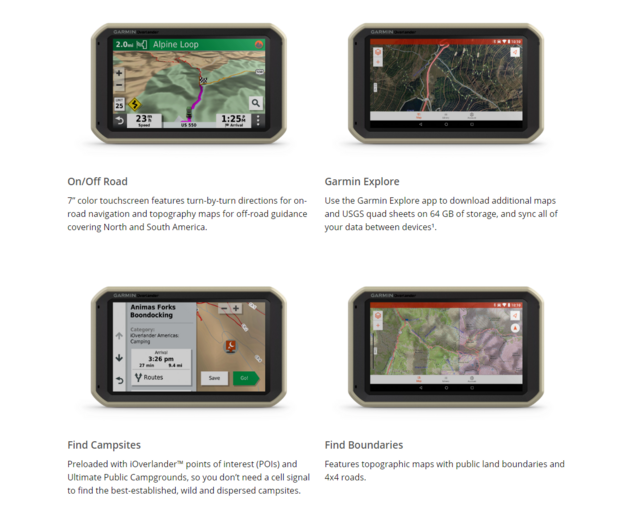
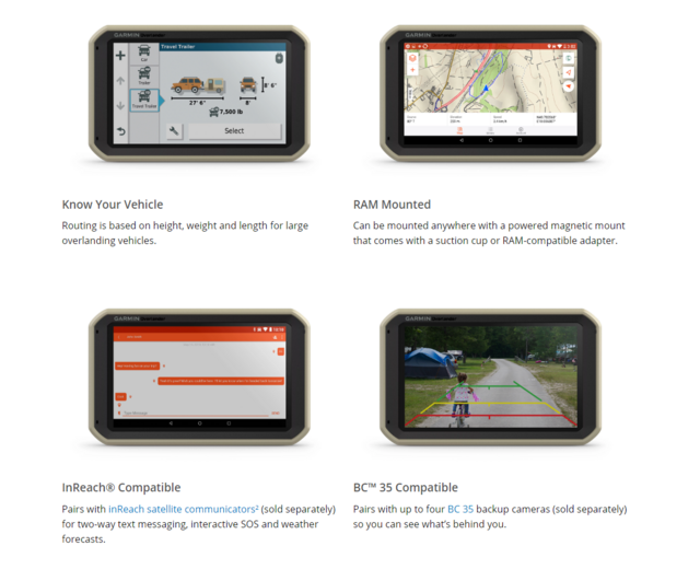
Built for every part of the journey, Overlander is a rugged, all-terrain navigator that can easily switch from turn-by-turn directions for on-road navigation to topography maps for off-grid guidance in North and South America.

Overlander features integrated pitch and roll angles as well as a compass, altimeter and barometer to help you and your vehicle navigate difficult terrain. A built-in rechargeable battery means you can even take it beyond your vehicle.

Create a Garmin Explore™ account to plan and map out your next adventure. You can easily record and create routes by tapping the screen on your Overlander navigator. Use your account to wirelessly sync — via Wi-Fi® connectivity¹ — your tracks, routes and waypoints across all your devices.

Garmin-1.png


Garmin-2.png


Overview -

YouTube
 
Last edited:
Register to hide this ad
This product makes no sense to me, even at half the price. Just get a good tablet and use any GPS program you want.
 
Agree - I've been using an older android tablet that was a hand-me-down, a bluetooth GPS puck (Dual XGPS 150A) and Gaia program. Pretty inexpensive set up, but very intuitive, and it has worked well on many trips. You just have to know the general area where you want to go to download the maps when you have internet connection.
 
I think the value proposition they are trying to deliver is having everything rolled into one system so no need to go from app to app or make sure you download maps, or directions from various apps over wifi in case you need them for later. Similarly other off-road oriented apps like Gaia don't do turn by turn which something like a Hema does in Australia. Depending upon how they've implemented it, I can definitely see it being useful in that role for some people though based on what they've published it does seem to be quite a bit overpriced for what it delivers.

Agree - I've been using an older android tablet that was a hand-me-down, a bluetooth GPS puck (Dual XGPS 150A) and Gaia program. Pretty inexpensive set up, but very intuitive, and it has worked well on many trips. You just have to know the general area where you want to go to download the maps when you have internet connection.

I've only been using Gaia recently and have so far done it mostly for hiking and love it. What I've always wished it had was turn by turn directions that include getting a trail or hiking spot and then going offroad to a spot you may have picked before hand etc. I think this is what Garmin is going after though as you wrote, with a tablet and 2-3 apps you can do most of the stuff as long as you plan and download everything for offline use or have access to data if you have an LTE tablet.
 
Last edited:
But there are loads of apps that do turn by turn, you dont need gaia to do turn by turn because you can use whatever you want
 
But there are loads of apps that do turn by turn, you dont need gaia to do turn by turn because you can use whatever you want

Which is your favorite turn by turn app for offroad/trail navigation or getting to your favorite or otherwise pre-determined camping spot?
 
It's cool that they are developing software and hardware targeting this specific hobby/interest just like they have already done for motorcycles, airplanes, boats, bicycles, runners, climbers, soldiers, etc. but I think it is way overpriced. If they had it at $399 retail with a street price of $350 they would probably sell a lot of them. Hold off for a year and when they sell like $hit you will probably be able to pick one up for that price.
 
Yeah it's way too overpriced imo. I'd pay $400 for something like this if it can help me declutter and not have to use both the phone and the tablet, though I guess for those with Apply Car play and Android Auto it may not be worth it.
 
Used android tablet and an external gps for Gaia is what I use and it cost me way less than Garmin’s device.


Sent from my iPhone using Tapatalk
 
Which is your favorite turn by turn app for offroad/trail navigation or getting to your favorite or otherwise pre-determined camping spot?

the easiest is to tap on the waypoint in gaia and select "driving directions" and it opens your default navigation app. if your default app is google maps you can download an area in advance if you won't have service. if you want a turn-by-turn app where you can download more data, then in my experience MapFactor GPS is probably the best although i haven't tried many (which uses OSM data so i wouldn't be surprised if it has some offroad areas too)

also, i'll point out that the garmin overlander only does turn-by-turn navigation onroad, offroad it uses topographic maps
 
the easiest is to tap on the waypoint in gaia and select "driving directions" and it opens your default navigation app. if your default app is google maps you can download an area in advance if you won't have service. if you want a turn-by-turn app where you can download more data, then in my experience MapFactor GPS is probably the best although i haven't tried many (which uses OSM data so i wouldn't be surprised if it has some offroad areas too)

also, i'll point out that the garmin overlander only does turn-by-turn navigation onroad, offroad it uses topographic maps

Thanks. I didn't know you could do that on Gaia so will give it a try! I've been mostly using our old iPad when we go out camping but am considering buying a used Android with external storage so that I can save larger maps directly on the device.
 
This seems to be trying to replicate the Hema GPS unit that seems to be so popular with aussie overlanders and off-roaders. I don't really get why they don't just use tablets over there. Possibly the GPS chip and antenna in a dedicated device is a little better/more accurate. But I am not sure that is worth the cost.
 
My personal opinion, this product was built for the Mall Crawling Content Creating "Overlander". Honestly the whole marketing scheme and release of this makes me feel like I've stumbled into Best Buy and asked a "professional" questions about tech stuff...

It is an overpriced 7", low resolution, and most likely low-spec'd Android tablet with mapping software and a drop-resistant case (which is ironic if it is supposed to be mounted in a vehicle). They tout it as "compatible with inReach" for messaging, however, ANY iOS/Android device with bluetooth is "compatible with inReach". The fact that several big name content creators all "switched" to it on the same release day (and Garmin's attempt to "buy" into the market by purchasing a pre-built marketing vehicle) just leaves a bit of a bad taste in my mouth, even if it was cheaper and with greater capabilities.

Low spec 7" Android tablets are a dime a dozen in the sub-$100 market space, and for just a bit over $100 I even got one with 3GB RAM, 2560x1600 LCD, and LTE. Combine that with the supremo GAIA subscription ($40/yr), and you get 15 years of usage/fees before equaling the price of the Garmin unit. Want better GPS acquisition, you can add a (fairly) inexpensive external GPS antenna and STILL be able to buy several entire setups compared to the price of the Garmin.
 
$700. Holy sheeeetz.

It looks like a ruggedized version of their RV 780 (which is $400). However, it's only IP5X - Dust Protected. No Water Protection.

I think you can get all the mapping capabilities from the RV780. The Overlander adds in some dust/shock protection, inReach compatibility (can send texts, SOS, get weather over satellite for $$), and an angle meter. Maybe the campground POI set is unique too.

Man, everyone is really trying to cash in on the overlanding craze.

I don't overland, but use Google Maps to pre-cache maps when I go backpacking or driving/exploring in remote areas. Turn-by-turn directions is nice.
I use BackCountry Navigator as well. I pre-cache 4 map sets (USGS Topo, CalTopo US 24k Topo, USTpop Imagry, and USA Topo Maps - ArcGIS) with BC Nav. Doesn't have turn-by-turn, but better mapping products than Google (and Garmin as well).

Garmin units are the 'easy' button, as there is no pre-caching required (unless you want satellite imagery). But I'd just buy the RV 780 for $400 and deal with no inReach integration (if I used inReach). Your phone is also inReach compatible, so you don't need the Overlander.

$700 is stupid money. This is coming from a Garmin fan who owns a FR935, Oregon 700, Edge 200, etc.
 
Last edited:
Meh, I paid that much for my Garmin watch and it's worth it considering the other 4 less expensive ones I bought that were subpar.

Which tablet are y'all buying that's $400 that provides topo information, off grid boundries information, satellite messaging and pitch and roll information?
 
Meh, I paid that much for my Garmin watch and it's worth it considering the other 4 less expensive ones I bought that were subpar.

Which tablet are y'all buying that's $400 that provides topo information, off grid boundries information, satellite messaging and pitch and roll information?

Any GPS-enabled Android tablet that costs $400! Here's one for $150 that would work fine and do all that stuff: https://www.amazon.com/Lenovo-Android-Quad-Core-Processor-ZA2J0143US/dp/B07DPV4RNK
 
Last edited:
Which tablet are y'all buying that's $400 that provides topo information, off grid boundries information, satellite messaging and pitch and roll information?

$400 gives you all kinds of Android options, even $200-$250 will get you a really good unit. And these will run whatever other apps you want, not just a single use device. $400 could give you a nice tablet, rugged case, ram mount setup and still have cash left over.
 
Which tablet are y'all buying that's $400 that provides topo information, off grid boundries information, satellite messaging and pitch and roll information?

As plenty have said, TONS are available... As for the satellite messaging function, it ONLY works if you have your inReach bluetooth paired to it, but at that point ANY phone or tablet w/ bluetooth works with the exact "satellite messaging" functionality.

Additionally, for those saying feeling that Garmin's topo maps are so much better, the Earthmate app, which is what is used for interfacing an Android/iOS device and the inReach satellite device), gives you access to Garmin's mapping (incl. multiple map layers), satellite tracking data, etc, etc.

Essentially Garmin is charging ~$300-500 for combining things that are readily available, and removing some features (such as making it "single use" vs. a multi-use tablet)
 
Garmin Overlander topo map wayfinding

Here's a link the Garmin Overlander, sells for $700:
Garmin Overlander™ | Navigation for Overlanding

How does this compare to the Garmin Oregon 750t GPS for $500 ?

Or the Garmin inReach Explorer+ 2-Way Satellite Communicator, typically $450 can be found on sale for $400 ?

Or the Oregon 700 for $400:
Garmin Oregon(R) 700 | Hiking GPS

The ideas here for using an iPad or android pad and a GPS ap sound great. What about using an iPad2 with these same aps? Has anyone tried an iPad? I have an iPad 2 sitting around.
 
Last edited:
Yeah it should be clarified that the Garmin overlander doesnt do satellite messaging alone, that requires you to also have an inreach... the exact same as with iOS/Android
 

Members online

Forum statistics

Threads
278,309
Messages
3,554,066
Members
248,016
Latest member
Advally Service

Trending content

Back
Top