Joshua tree yellow post

We just got back from camping in the area [MENTION=123332]Drunner97[/MENTION] posted. It was a nice spot to camp, especially with kids and a dog. We also explored some areas of the Old Dale BLM area and decided we'll need to go back to camp and do some more exploring. It was a lot of fun driving those trails and checking out some mines. We took the scenic route back today and drove through JTNP on Geology Tour Road and then left the south end of the park through Berdoo Canyon. It was a great weekend in high desert!

I'll post some photos after I get the kids scrubbed and in bed.
 
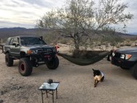
There were several groups already occupying sites when we arrived on Friday, so we continued down toward the park boundary and found a nice, fairly secluded spot.

30856132972_43407d5303_z.jpg


Other than along Gold Crown Rd in the BLM area north of JTNP, we saw very few people most of the day. Here is a shot from a section of the trail that opened up across this large, flat area that provided a view of most of the valley. Welcome to Mars.

30937113626_650e04e767_z.jpg


Pleasant Valley, JTNP

30856288842_240b257706_z.jpg


You'll have to excuse the cell phone photos and lack of photography skills.

 
There were several groups already occupying sites when we arrived on Friday, so we continued down toward the park boundary and found a nice, fairly secluded spot.

30856132972_43407d5303_z.jpg


Other than along Gold Crown Rd in the BLM area north of JTNP, we saw very few people most of the day. Here is a shot from a section of the trail that opened up across this large, flat area that provided a view of most of the valley. Welcome to Mars.

30937113626_650e04e767_z.jpg


Pleasant Valley, JTNP

30856288842_240b257706_z.jpg


You'll have to excuse the cell phone photos and lack of photography skills.

It's unfortunate that those out of the way spots are getting a tad more popular, but they're typically spaced out far enough to where you aren't on top of each other like the usual campground. Glad you guys had fun. Headed to Death Valley in a week, Mojave Road in December, then I think I'm going to need to take January and February off just to plan for the March JT run.
 
Well just got back from first time JT. Weather was nice. Not a pic kinda guy but took a couple. Want to go back February or March to scope out reptiles. Camps were full so a little ruff trying to find a nice spot
 

Attachments

  • IMG_3318.jpg
    IMG_3318.jpg
    136.9 KB · Views: 257
  • IMG_3319.jpg
    IMG_3319.jpg
    145.9 KB · Views: 259
  • IMG_3320.jpg
    IMG_3320.jpg
    125.4 KB · Views: 243
Actually had more fun coming home. 10 fwy was bumper to bumper so exited at the 62 and hit the dirt roads along the 10 passing traffic almost up to morongo. That was pretty cool !
 
34.112784, -116.283733 - Bigger one that we had our main camp at

34.112866, -116.280115 - Smaller one

34.112306, -116.284739 - Smaller one

Potential Alternatives that haven't been scouted out

34.114960, -116.281847

34.110126, -116.279171

34.109860, -116.269008
.

Tries to hit these spots today but couldn't got past a gate that was closed and read day use only!! Is this new or changes depending on the seasons?
 
Tries to hit these spots today but couldn't got past a gate that was closed and read day use only!! Is this new or changes depending on the seasons?

That's likely the gate for the conservation area. You have to pass through the protected space to get to the BLM land that is adjacent to the park boundary. I wonder if they temporarily (or permanently?) closed the access gate. There has been a problem with illegal camping for a few years. People don't go far enough to the east and several "campsites" have developed that are actually in the conservation area.
 
Tries to hit these spots today but couldn't got past a gate that was closed and read day use only!! Is this new or changes depending on the seasons?

Dunno. Haven't tried those spots in quite awhile. We usually camp off Gold Crown Road and the 62 now. Could be closed because of the shut down.
 
Thanks [MENTION=123332]Drunner97[/MENTION] [MENTION=140870]Offcamber[/MENTION] .... Do either of you have the GPX or which ever file list that was offered in this thread earlier?
 
Thanks [MENTION=123332]Drunner97[/MENTION] [MENTION=140870]Offcamber[/MENTION] .... Do either of you have the GPX or which ever file list that was offered in this thread earlier?

Post 43 has a link to Miah's maps, if it's still viable. Otherwise you basically just take the 62 to Gold Crown Rd. From the 62 to the top of Old Dale Rd (there's a sign that is the park boundary) is pretty much all BLM land. Pick a side road, explore some mines, and find a place to camp. You'll see the random fire ring here and there along the sides of the roads where people have camped previously.
 

Members online

Forum statistics

Threads
278,309
Messages
3,554,075
Members
248,016
Latest member
Advally Service

Trending content

Back
Top