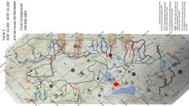
Thanks to [MENTION=137555]Sleeter[/MENTION] and [MENTION=68689]Pkniland[/MENTION], I've put together a consolidated set of GPS tracks that map the trails from the weekend.
There are two files attached to this post. Both files contain the tracks, but one combines the tracks with a topo overlay from [MENTION=132027]OneGreenTaco[/MENTION] (posted earlier in this thread) containing trail names. The filenames should make it clear which one has the overlay included.
Remember that you'll have to remove the .pdf from the filename for them to work in Google Earth and/or your GPS application. I had to add this as a workaround to upload them here (kmz/kml filetypes aren't allowed by the t4r forum software).
If you have any trouble or questions feel free to let me know. Otherwise, thanks for sharing guys and hopefully I'll be able to join everyone next year.
Attachments
Tracks from 2016 T4R October Camping Trip #5 v.1.0.kmz.pdf
44.8 KB
· Views: 109
Tracks with overlay from 2016 T4R October Camping Trip #5 v.1.0.kmz.pdf
Thanks to [MENTION=137555]Sleeter[/MENTION] and [MENTION=68689]Pkniland[/MENTION], I've put together a consolidated set of GPS tracks that map the trails from the weekend.
There are two files attached to this post. Both files contain the tracks, but one combines the tracks with a topo overlay from [MENTION=132027]OneGreenTaco[/MENTION] (posted earlier in this thread) containing trail names. The filenames should make it clear which one has the overlay included.
Remember that you'll have to remove the .pdf from the filename for them to work in Google Earth and/or your GPS application. I had to add this as a workaround to upload them here (kmz/kml filetypes aren't allowed by the t4r forum software).
If you have any trouble or questions feel free to let me know. Otherwise, thanks for sharing guys and hopefully I'll be able to join everyone next year.
Finally got a free moment and downloaded my tracklogs from the trip. These should be pretty spot on as I run an external hockey puck on the truck. I maintained 12 birds the entire trip.
I did find during the trip, the overlay was off in spots, and I confirmed this with my tracks...north corner pretty close, less spot on down south. I tried adjusting the overlay in Google Earth, but couldn't get it spot on everywhere, so my feeling is the scanned map I used was probably a photo and needs skewed some to line up everywhere (GE doesn't let you stretch corners).
I got a ton of extra data while out. She sat in the passenger seat and took notes, so I will update the trail names and definitely update some trail colors, as well as a few extra landmarks. I'll get the updated one out when I finish it up.
The last great big "gusto" I will attempt is to make a Google map overlay that can be shared out, then everyone can pull it up on their phone. I did one for my property boundaries back in the day and I can get to it on my phone anytime....would be pretty nice.
All in all, tracking it close-ish on the phone, while she tracked and updated the map, made things pretty nice, and I actually knew where the hell I was the whole time.
We are a bit nuts... but... [MENTION=132027]OneGreenTaco[/MENTION] got us out of some pretty tight spots. He's worth his weight in gold as a trail guide and spotter. :naughty:
Luckily, you guys don't know my value as a trail mechanic. I once rigged a tree and two ratchet straps to and F150, to hold a broke axle in for 1.5 miles so we could get it off the trail. One of the things I like about wheeling with Yotas...don't need many tools (unless you lock your keys in newer 4RNR...that thing was locked up like Ft Knox, and we used a couple tools). If we was one of the big three forum offroading groups, we would have done one third of the trails, and the campground would have looked like a scrap yard/parts swap meet buy Sun evening.
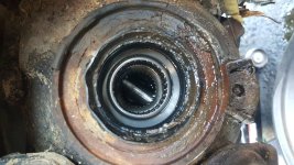
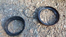
Sooooo...my little drive through the big mud hole beside Yogi's dumpster did end up costing me two front axle seals. I bulldozed all the goopy stuff in the bottom of that mud hole, into every orifice and crevice (yes Jeff and Corey, I said orifice), of the front of my truck. The mud packed so much around those axle seals, the outsides deformed...driver side seal fell apart when removed. Good news story, no contamination of the front diff. $35 in seals, couple broken hub bolts, everything is tippy top. At 150K miles, killing two original axle seals is pretty low drama. Took the extra time to clear everything out of my calipers. That mud really got packed in there everywhere. I'm also happy to report Toyota door seals must work really well, or she would have gotten wet up to at least her belly button in the passenger seat. I pulled several 3" size rocks from behind my front skid. Snorkel did its job.
Luckily, you guys don't know my value as a trail mechanic.
I bulldozed all the goopy stuff in the bottom of that mud hole, into every orifice and crevice (yes Jeff and Corey, I said orifice), of the front of my truck. Snorkel did its job.
I just laughed again for the third time at your new signature block.... lol. I'm guessing my couple inches of extra height (and my excessive speed) saved my airbox from getting flooded. Waterline was up past the door sill and nothing in the cabin. Amazing trucks these are. I did the first powerwash on Saturday, but today it appears there is still mud wedged between the skid and the oil pan. I am not taking that thing off! :Cry:
I just laughed again for the third time at your new signature block.... lol. I'm guessing my couple inches of extra height (and my excessive speed) saved my airbox from getting flooded. Waterline was up past the door sill and nothing in the cabin. Amazing trucks these are. I did the first powerwash on Saturday, but today it appears there is still mud wedged between the skid and the oil pan. I am not taking that thing off! :Cry:
It's your serpentine belt not going all the way to the top of your engine slinging water everywhere that saves you mostly. One of the only downsides to having the supercharger on top...my crank hits water, then my engine bay is instantly covered. Fuggit, I gots a hoes....urrrr hose.
hello Im Chris (black 4th gen) first post on this site. Im very glad I made this trip had a great time wheeling with you guys cant wait to do it again. dinner was awesome too.
hello Im Chris (black 4th gen) first post on this site. Im very glad I made this trip had a great time wheeling with you guys cant wait to do it again. dinner was awesome too.
Thanks to [MENTION=137555]Sleeter[/MENTION] and [MENTION=68689]Pkniland[/MENTION], I've put together a consolidated set of GPS tracks that map the trails from the weekend.
There are two files attached to this post. Both files contain the tracks, but one combines the tracks with a topo overlay from [MENTION=132027]OneGreenTaco[/MENTION] (posted earlier in this thread) containing trail names. The filenames should make it clear which one has the overlay included.
Remember that you'll have to remove the .pdf from the filename for them to work in Google Earth and/or your GPS application. I had to add this as a workaround to upload them here (kmz/kml filetypes aren't allowed by the t4r forum software).
If you have any trouble or questions feel free to let me know. Otherwise, thanks for sharing guys and hopefully I'll be able to join everyone next year.
OK kiddos, got the map updated. Trail names, colors, landmarks, and a couple new trails added. This thing should be pretty good. I'll update each year with new conditions, as we all know, the trails change.
I also created a new rasterized kmz from scratch for the overlay. I found out the problem with the last one for Garmin and several of the other phone apps I tried, was that the first one carlos created, was made with a png vs a jpeg. This isn't an issue for most PC based software, but is a big no no for Garmin, and turns out many others. I found one app that would do it, and it worked well enough to allow me to log and document the weekend much more accurate. I adjusted it so it is pretty spot on now. I have confirmed custom map works on Garmin, have it on my phone a few different ways now.
Oh, and I forgot...my woman bought me a TireGate!!! Her and Corey were plotting and being slick. Came home to a large Wilco box in my parking spot.:guitar3:



 You can see the slider did it's best to try and stop it at least!