
You are using an out of date browser. It may not display this or other websites correctly.
You should upgrade or use an alternative browser.
You should upgrade or use an alternative browser.
October in Crested Butte
- Thread starter JMG73072
- Start date
Register to hide this ad

Jimmy_D
Member
You're welcome to track me down before you hit CB. I'm there summer and fall. I leave when it gets too cold for comfort. If it doesn't snow much by the middle of October I'll still be there. Even if I'm gone by the time you arrive I can hook you up with some of the locals in our 4-wheel group. The group is usually active till there's too much snow to get out for a run.

JMG73072
New member
You're welcome to track me down before you hit CB. I'm there summer and fall. I leave when it gets too cold for comfort. If it doesn't snow much by the middle of October I'll still be there. Even if I'm gone by the time you arrive I can hook you up with some of the locals in our 4-wheel group. The group is usually active till there's too much snow to get out for a run.
Jimmy
Thank you, I will be in touch as the time nears for sure.

ToyotaDoodz
New member
Any locals or non locals have any trail recommendations for the area, of course weather pending that time of year. I am traveling there 10/8-11. Any suggestions are appreciated. I'm up for someone to join me too if wanted.
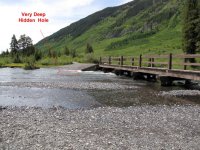
John, there are are several trails in the area but I wanted to warn you about one, Gunsight Pass. It's actually not the trail itself, but the river crossing to access it.
The access to Gunsight Pass is right out of Crested Butte on the Slate River Road. To access the trail you must cross the Slate river. It is ALWAYS high in the spring as are most of the rivers and water crossings in CO, but this crossing has developed a deep hole just East of the bridge on the far side. Deep as in "over the hood" deep even in late summer. I know for a fact that the hole has been there since 2010 and is still there. I just came back from there two days ago. There are no warning signs but many of the locals know about it as it provides several hydro locked vehicles to the local shops every week in summer. It's the local dirty little secret. This comes direct from two different shop owners in CB.
It is possible to make it across if you know where the hole is, but it changes. My advice to you is don't run this trail unless you personally walk across "in the water" to check the depth. It is very deceiving and shallow looking from the entrance side. Also, the bank on the other side is very steep compared to the entry side. The clear water is deceiving.
PS, the ATV's have been cheating and cutting across upstream of the bridge, but I don't recommend that. Tread lightly you know!
Attachments
Jimmy_D
Member
In October the crossing in that spot isn't bad at all. The water level is down considerably by then. This time of year with as much snow as there is still up in Paradise Basin I wouldn't dream of attempting it until the water level goes down substantially. Year before last the hole you mentioned was extremely treacherous, but wasn't bad at all last year, so you never know.
ToyotaDoodz
New member
In October the crossing in that spot isn't bad at all. The water level is down considerably by then. This time of year with as much snow as there is still up in Paradise Basin I wouldn't dream of attempting it until the water level goes down substantially. Year before last the hole you mentioned was extremely treacherous, but wasn't bad at all last year, so you never know.
Agreed!
No, I would never attempt in Spring or even mid-summer. I was there last week and was curious and snapped a pic to post here. When they beefed up the shoring under each end of the bridge several years back, it created a strong whirl pool effect where I drew that circle. I've personally seen several drowned vehicles in that hole in late August and September when the river looked very calm and low. All it seems to matter is a track that's off by 2 feet or so. The entry is so shallow and flat, it beacons to the unknowing.
Bad part about attempting with a 4Runner is the air intake is in the right front wheel well which is in the lowest spot if you happen to hit that hole just right.
I know your group will take good care of him if you meet up, I just wanted him or others that might be unaware to be warned. Those are the ones that get into trouble since it is not marked in any way. I have some pics of drowned 4Runners in that hole, but they're just too heartbreaking to post and the Jeepers would love it too much.
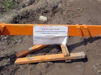
PS, this sign was posted just past Gothic last week. It may take some time to fix.
Attachments
Last edited:
Jimmy_D
Member
Yeah, before they did the work around the bridge several years back, getting across that spot was never hazardous to any real extent (you could cross the stream on the other side of the bridge if there was any threat). Several of us went through it in our FJ's a while back when the hole was VERY deep. It was an adventure. Not to mention the fact that my FJ wouldn't go into 4-wheel drive (dreaded sensor malfunction) before I went across. I realized in the middle of the hole that I wasn't going to make it. I threw it into reverse and managed to back up before things got ugly. I had installed a rear locker bypass switch (in case the sensors did malfunction) and after engaging the rear locker went back across. As far as the Gothic road goes this year, it would appear that there's a very good chance it won't be open to Schofield Pass at all this season. Hopefully the Paradise Divide route to Schofield will open up at some point. It will be interesting to see what condition the Punch Bowl is in when someone can manage to make it there. The Schofield Pass-Punch Bowl-Lead King Loop run is one of the best runs around here. We usually do it a couple of times every summer/fall.
ToyotaDoodz
New member
Yeah, before they did the work around the bridge several years back, getting across that spot was never hazardous to any real extent (you could cross the stream on the other side of the bridge if there was any threat). Several of us went through it in our FJ's a while back when the hole was VERY deep. It was an adventure. Not to mention the fact that my FJ wouldn't go into 4-wheel drive (dreaded sensor malfunction) before I went across. I realized in the middle of the hole that I wasn't going to make it. I threw it into reverse and managed to back up before things got ugly. I had installed a rear locker bypass switch (in case the sensors did malfunction) and after engaging the rear locker went back across. As far as the Gothic road goes this year, it would appear that there's a very good chance it won't be open to Schofield Pass at all this season. Hopefully the Paradise Divide route to Schofield will open up at some point. It will be interesting to see what condition the Punch Bowl is in when someone can manage to make it there. The Schofield Pass-Punch Bowl-Lead King Loop run is one of the best runs around here. We usually do it a couple of times every summer/fall.
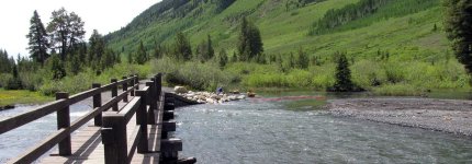
This year, it appears that they've added and extended the riprap with a string of large barrier rocks (see red dashes on pic at bottom) on the far upstream side to prevent people from crossing on that side. They are hard to see in this pic below because they are submerged but they are there. I used to watch ATV's cross there. Having out of state plates and treading lightly, I never crossed on that side. The pedestrians and mountain bikers were giving all vehicles enough dirty looks for being on "their" trail as it was.
You were very lucky to back out of that hole. Stopping forward momentum in deep water is very tough. Most are tempted to hit the gas hard to power through and just suck in more water in the process.
We love the Paradise area. It's a favorite lunch spot. This was in my 2001 during a September run.

Attachments
ToyotaDoodz
New member
I plan to be there in early August, anything else I should be aware of? Debating taking my travel trailer but haven't decided yet as I haven't brought it in the past. I'll be coming with a friend from IL who comes once a year to enjoy Colorado.
That's all I was able to discover on our early trip around Crested Butte. We were not able to get very far in the CB area trails so hopefully the wheelers that are there now will chime in before your trip.
Have a blast!
Jimmy_D
Member
Everything is currently open so it depends on what you want to tackle. The Schofield Pass/Punchbowl/Lead King Basin loop is spectacular. The Pearl Pass to Taylor Pass and back loop is also terrific (our 4 wheel group here in CB will be doing it Monday after next.......weather permitting). There are plenty of other options.....kind of depends on what you want to experience.
Everything is currently open so it depends on what you want to tackle. The Schofield Pass/Punchbowl/Lead King Basin loop is spectacular. The Pearl Pass to Taylor Pass and back loop is also terrific (our 4 wheel group here in CB will be doing it Monday after next.......weather permitting). There are plenty of other options.....kind of depends on what you want to experience.
Thanks Jim,
I'm looking for full day trail combinations. I've done Schofield/Punchbowl but my wife doesn't want to do it this trip. We had a sidewall cut last time and she wasn't thrilled. Might just have her walk the Punchbowl because I like it. Last trip we did Italian Creek to Reno Divide to Cement Creek too.
I'll have a friend with me and he's a pretty good driver so we want to see it all. I haven't done Taylor/Pearl so that's one. I'm really open to suggestions of any combo of trails that won't leave me driving the pavement to get back to CB.
Chris
Last edited:
Jimmy_D
Member
We did Cement Creek/Reno Divide/Upper Italian/Flag Mountain/Spring Creek a couple of weeks ago. Upper Italian will definitely get your attention. Another good one is to start in Tincup (which is a few miles south of Taylor Reservoir) and do the Cumberland Pass/Hancock Pass/Tincup Pass loop back to Tincup (or you could do it reverse to what I've suggested). There are several options off of that loop. Napoleon Pass runs pretty much parallel to Cumberland and is an option in lieu of Cumberland. Williams Pass is another option and is only open during the month of August. It runs from the Alpine Tunnel side road off of the trail connecting Cumberland to Hancock and cuts back to Hancock. You can also do the Grizzly Lake out and back trail that starts just after you get onto the Hancock Pass trail, which takes off from the main road heading into St. Elmo (where the Tincup Pass trail begins/ends.....depending on which way you're running it).
Last edited:
We had a great time in CB. Ran Cement Creek/Reno Divide/Italian Creek/Taylor on our first day. Paradise Divide the next then Paradise Divide to Schofield Pass to Washington Gulch. Day Four was rainy so we went to Redstone & Marble via McClure Pass/Kebler Pass. Day Five was a day off followed by Pearl Pass before heading to Ouray.
Pearl Pass was new to me and I loved every minute of it (until we had to hit the pavement to get back.) :doh:
Pearl Pass was new to me and I loved every minute of it (until we had to hit the pavement to get back.) :doh:
JMG73072
New member
We had a great time in CB. Ran Cement Creek/Reno Divide/Italian Creek/Taylor on our first day. Paradise Divide the next then Paradise Divide to Schofield Pass to Washington Gulch. Day Four was rainy so we went to Redstone & Marble via McClure Pass/Kebler Pass. Day Five was a day off followed by Pearl Pass before heading to Ouray.
Pearl Pass was new to me and I loved every minute of it (until we had to hit the pavement to get back.) :doh:
How was Pearl? That's on my list to do if it is still open the second week of Oct.
How was Pearl? That's on my list to do if it is still open the second week of Oct.
Pearl Pass was great, I had never run it before and will again. It's a high pass and I suspect it'll have snow by the time you get there. I hope not but the odds are against you.
JMG73072
New member
As I mentioned previously, I'm currently scheduled to be in Moab that weekend but my buddy Joe, who drives an FJ, isn't going to Moab with me because of some obligations here in CB so I'll ask him if he wants to show you around. He knows the trails around here as well as I do.
That's great Jim. Thanks, John
Similar threads
- Replies
- 3
- Views
- 2K

- Replies
- 0
- Views
- 2K

- Replies
- 1
- Views
- 1K


