Planning my 2017 Death Valley trip. How does this route look?

4Rager

New member
I will probably be going sometime in March or April, but after reading more about the backcountry cabins I decided this year's trip needed to include one, so I started putting a route together.

I think this looks pretty good since it keeps it under 200 miles between fuel stops. My one question would be, is there a way from 395 over to the Ballarat area on dirt, without taking the main road through Panamint Springs? I see that the China Lake Naval Weapons Center covers most of that areas, so I'm guessing that's why it doesn't look like there's any trails going through there.

The only other unknown is picking a camping spot for the night in Stage 4. Could just be the Warm Springs hot springs (never been) or somewhere north towards Wheeler Canyon.

Let me know what you guys think. I've never been that far south in the park, so I have no experience south of Furnace Creek.

Stage 1: Reno to Lone Pine (254 mi)
Stage 2: Lone Pine to Mengel's Pass cabin (105 mi)
Stage 3: Mengel's Pass cabin to Furnace Creek (69 mi)
Stage 4: Furnace Creek to Big Pine (159 mi)
Stage 5: Big Pine to Reno (212 mi)

Tfvif3t.jpg
 
Register to hide this ad
NW portions of park

Looks like a nice trip, although I'm not real familiar with the southern portions of your route. Check out this site,

Death Valley Talk.com Archives

for great information on the area. The site has had issues in recent years and appears to be mostly dead, but the archives are awesome, full of information from locals.

March is the end of the desert season for me, and April can be way too hot already. LOL, you'll see.

Day 1 out of Lone Pine: If you're looking for some dirt, consider going up to Cerro Gordo and then down the backside to Lee Flat. From there you can cut south to Hwy 180. Great views and rock collecting, just don't pick up any rocks on mining claims. Or if you really like off-camber, steep-ass loose dirt with cliffs of death, take the Swansea-Cerro Gordo Loop, and then drop down into Lee Flat, etc.

I do not believe there are any trails from Darwin to Ballarat, except maybe one down to Darwin Falls, if it hasn't been closed or washed away. But that doesn't even get you close.

Fast forward to The Racetrack: Sunset and Sunrise over the Racetrack can be psychedelic. But I prefer a mile or two down the road, to the top of the Lippincott Grade, past Homestake Camp and the Warning: You Will Die If You Drive This Road signs. There's another epic view out over Saline Valley.

If you're driving through Saline Valley, then you really do need to visit Warm Springs and Palm Spring. It's about 7 miles of 15mph, sandy road with fun whoopdee-do's. You can go faster but you might lose the gas can off your rear bumper and have to backtrack to get it, ha. Don't visit the springs if nudity and strange people bother you.

If you want to head further north before camping, the Waucoba Springs area has some interesting features including massive quartz crystals, fossils, and Native American sites. Of course it is illegal to collect any rocks or cultural resources in a national park.

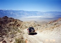
Here's a pic from the top of Lippincott, looking out over Saline. If you take the Swansea Cerro Gordo loop, you'll be on top of those mountains:
 

Attachments

  • Lippincott.jpg
    Lippincott.jpg
    139.6 KB · Views: 334
BTW, if you go through Cerro Gordo, don't even think about stopping there! The owners are very unfriendly and do not tolerate visitors of any sort.
 
Looks like a nice trip, although I'm not real familiar with the southern portions of your route. Check out this site,

Death Valley Talk.com Archives

for great information on the area. The site has had issues in recent years and appears to be mostly dead, but the archives are awesome, full of information from locals.

March is the end of the desert season for me, and April can be way too hot already. LOL, you'll see.

Day 1 out of Lone Pine: If you're looking for some dirt, consider going up to Cerro Gordo and then down the backside to Lee Flat. From there you can cut south to Hwy 180. Great views and rock collecting, just don't pick up any rocks on mining claims. Or if you really like off-camber, steep-ass loose dirt with cliffs of death, take the Swansea-Cerro Gordo Loop, and then drop down into Lee Flat, etc.

I do not believe there are any trails from Darwin to Ballarat, except maybe one down to Darwin Falls, if it hasn't been closed or washed away. But that doesn't even get you close.

Fast forward to The Racetrack: Sunset and Sunrise over the Racetrack can be psychedelic. But I prefer a mile or two down the road, to the top of the Lippincott Grade, past Homestake Camp and the Warning: You Will Die If You Drive This Road signs. There's another epic view out over Saline Valley.

If you're driving through Saline Valley, then you really do need to visit Warm Springs and Palm Spring. It's about 7 miles of 15mph, sandy road with fun whoopdee-do's. You can go faster but you might lose the gas can off your rear bumper and have to backtrack to get it, ha. Don't visit the springs if nudity and strange people bother you.

If you want to head further north before camping, the Waucoba Springs area has some interesting features including massive quartz crystals, fossils, and Native American sites. Of course it is illegal to collect any rocks or cultural resources in a national park.

Here's a pic from the top of Lippincott, looking out over Saline. If you take the Swansea Cerro Gordo loop, you'll be on top of those mountains:

Thanks for the detailed response, that's great info. I agree about the heat, so I want to make the trip a few weeks earlier this year. Last year we were up at Eureka Dunes for half the trip, and it wasn't hot since that's ~3000ft elevation. But then we took a little side hike to the Red Wall south of Furnace Creek and it was 95 and I was roasting. This was the first week in April.
 
There're a couple good campgrounds past Racetrack Playa, just beyond your turn off to Lippencott. One pretty good sized cement slap up on the hill and then a cold-a-sac type road with dispersed camping at the base.

Not a bad spot to break up Day 4, but then your exit to Big Pine is a haul, but scenic!

Taking another look at your stages, all seem very do able. You're doing a lot of on road driving with only a couple hundred on dirt. Good course to see a lot of the park.
 
Last edited:
Thanks for the input. My "stages" are more just breaking up fuel stops to make sure it's less than 200 miles per tank. I will definitely be spending the night somewhere near/past Racetrack Playa on the second night or revising the route to add a third night.
 
No dirt road across the Argus range from the 395 to Ballarat, China Lake as you stated ...

I've done your whole route several times, it's really awesome ...

One quick tip: Don't count on finding any of the cabins in Butte Valley open. Especially if you come down off Mengel pass after dark, those cabins will probably be occupied by other travelers. So have a backup plan if you can't stay in a cabin. Good thing there are many spots to pull over and car camp in Butte Valley if you need to .

Homestake CG is right at the top of Lippincott pass and it would make a nice campsite for your stage 4....
 
Looks like a great run. I've traveled that same path before. I would say you'll need a few days full driving and two nights in DV area for the trip. When you're out there camping be sure not to camp in a flash flood zone. It is the season and it's no joke in *Death* Valley. On the forestry service and government maps there are usually markings for old campsites that have since been abandoned, combined with GPS app you should be able to find one in the daytime.

Are you going alone, single truck? Don't. That trip, Lippincott in particular is sketchy for only a single truck. If you insist on going alone be sure to bring a portable HAM and a weeks worth of food and water. I broke down in Death Valley. Trust me you don't want to be that guy. Death Valley has so little cell phone service (even in 2016) that you can drive around on the cement roads for 45mins to an hour and get 0 cell service.

There're a couple good campgrounds past Racetrack Playa, just beyond your turn off to Lippencott. One pretty good sized cement slap up on the hill and then a cold-a-sac type road with dispersed camping at the base.

Yep we camped right there after driving up Lipincot and stopping just before the Racetrack.
 
Last edited:

Members online

Forum statistics

Threads
278,316
Messages
3,554,120
Members
248,016
Latest member
Advally Service

Trending content

Back
Top