So i know a few guys here are running LeadNav [MENTION=123332]Drunner97[/MENTION] comes to mind.
I just downloaded it and wanted to buy the transparent layer of California trail map.
I think I have it figured out someone tell me I’m wrong?
I need to upgrade to a satellite or Topo within leadnav(for offline use), then download the transparent layer of CTM onto my computer, then transfer that map into the leadnav app via iTunes
So i know a few guys here are running LeadNav [MENTION=123332]Drunner97[/MENTION] comes to mind.
I just downloaded it and wanted to buy the transparent layer of California trail map.
I think I have it figured out someone tell me I’m wrong?
I need to upgrade to a satellite or Topo within leadnav(for offline use), then download the transparent layer of CTM onto my computer, then transfer that map into the leadnav app via iTunes
i use locus maps pro on android
No need to upgrade. You are correct about loading maps through itunes.. if you are going to be away from cell service and still want the sattlite image you can casche it ahead of time... personally i like the topo maps from CTM.. the transprent does show park boundries.. you can get all maps in one purchase.. or make your way to rancho cucamonga with a usb drive![]()
The app only shows I can download street view( no satellite) for offline use. Is there a way around that?
I may take you up on that bud! My iPhone is only 16gb i planned on having all the CTM maps on a external iPhone friendly usb drive and upload them before a run and remove them after the run is over and repeat. You think that would work out?
Happy thanksgiving everyone. I’m thankful for all the great new friends we’ve made over the last year. Our thanksgiving views:
Pretty sure the bypass on gatekeeper has been closed for awhile. Gatekeeper is the "optional" hard line between Odessa and doran. I'd be very skeptical of anything I read on a 3rd party site without evidence that BLM is closing trails. That whole area is incredibly popular as an ohv area.So I was scrolling around trailsoffroad.com downloading some gps tracks and it appears BLM is planning to close most of the trails in the area... Doran,Phillips,pretty much the whole area. I don’t know if this is an ongoing thing but we can’t be silent. Spread the word on FB groups, friends and whoever. We need to flood their offices with calls to show this is unacceptable.
https://www.trailsoffroad.com/state...search[highest_elevation][max]=&commit=Filter
BLM has plans to close most of the trails in the area, please call Matt Toedli at 760-252-6026 and voice your opinion
[MENTION=117408]Oneluv13T4R[/MENTION] is this the same guy you dealt with in September?
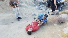
Looks like I'm out of commission until almost February. Dislocated my elbow in Death Valley, tore the ligaments and tendons, avoided a major break, but I'll be in a sling and going through physical therapy for the next 6-8 weeks. So no wheeling, lifting, camping, maintenance, or much of anything until I'm cleared by the doctor.

Bahahahahaha yup. You pull that off tw?Im guessing this is you then
No idea. I took a step up the side of the hill you see me laying on, foot slid out from under me, put my arm out to stop the fall and it was just the right angle and right amount of pressure to pop it through the joint. Paul, the guy over me, was able to coax it back into place. He had mountain rescue experience so I'm assuming some EMT experience along with it.How in the hell did you dislocate your elbow?
Bahahahahaha yup. You pull that off tw?
Sent from my Nexus 6 using Tapatalk
That’s my buddy Paul that’s posing on you LOL!!!!!