

TheSentinel
New member
Current info as of 4/29/16 @7:30pm
APRIL MEET UP AND TRAIL RUN
The meet will be Saturday, 30 April at 9:00am. The run will be Cleghorn to Pilot Rock to Lake Arrowhead.
Difficulty: Easy trails with challenging side trails.
Organizer(s): TheSentinel (Jason)
Trail Leader(s): CrazyNorwegian, TheSentinel, Oneluv13T4R
Meet Location: @ 9:00am-- we will begin the safety briefing and hit the trail by 9:15am
I-15 Cleghorn Road Offramp: Cajon Pass, CA
Meet location:
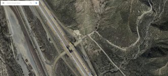
From Los Angeles or San Diego, navigate to I-15 N, after I-15 merges with I-215, proceed 5 or 6 miles and exit at Cleghorn Road. We will meet in the assembly area.
Route:
Pilot Rock via Cleghorn: 2N47>>Silverwood Lake (138)>>2N36>>2N33 (Pilot Rock)>>3W14>>Lake Arrowhead
Cleghorn route map
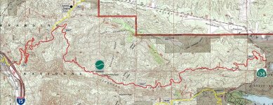
Pilot Rock route map

Communication:
CB Channel/ FMRS Chanel:
13/13.1
FRS 467.6875 PL 67.0 on simplex
HAM:
146.460 simplex
Roster:
Team Challenge (Difficult Group) - Trail Leader: CrazyNorwegian (HAM)
2. J – S&C Coach
3. Dezert4Runner
4. Marcocopuffs
5. drewskie88
6. Drunner97
7. TK-422 (CB and handheld FRS/GMRS)
Team Main Group 1 (Easy Group) - TheSentinel (Organizer) (CB/HAM handheld)
2. Azn-sensation
3. catherinehaataja13
4. Spenny
5. Kennys4runner
6. theking11863
7. VH3SURF
8. Mikeson
9. LMR
10. trayscool
11. davester00
12. cbr900boy
13. RobSiggy
Team Main Group 2 (Easy Group) - Oneluv13T4R (CB/HAM)
2. MACT4R
3. pokits
4. SoSoRunner
5. WFO_Racer
6. OutBreak
7. VH3SURF
8. 370HSSSV
9. drewskie88
10. Chsbrgr
11. Mjno87
12. Burnsie24
13. DustinJoints
If I have missed anyone, please PM me and I'll add you to the list. I would like to verify our numbers before heading out. If you want off the roster, let me know in a PM.
What to bring with you:
Good Attitude - This group is big...we'll need to be patient with each other
Bring food, beverages (no alcohol consumption en route please)
Spare fluids for vehicle
Recovery gear if you have it.
Recovery point front and rear (factory hook is fine)
Description:
[URL="http://www.dirtopia.com/wiki/Cleghorn_Ridge_Trail]Dirtopia Cleghorn Ridge Trail[/URL]
Cleghorn Ridge Trail is a combination of two parallel trails, one difficult and the other easy that intersect at several points. Beginning at Silverwood Lake, California Hwy 138 Google Map this trial offers ridge top views over Mount Baldy and ends at I-15 Cajon Pass exit 129 Google Map or back to Hwy 138 again Google Map The difficult trail runs from Silverwood Lake entrance to this intersection, the rest is easy.
The roughly graded route in this trail is suitable for medium clearance 2WD in dry weather. The US Forest Service has designated this trail as 2N47.
There is a separate 4WD trail (marked as X2W47) that runs parallel to the main route and is smaller. This one intersects the main trail often and has a rating of "difficult". The good news is that drivers are able to view the route beforehand and can choose the sections they want to leave out. The start of the trail has an easy rating which gets tougher as you move towards the top of the Cleghorn Ridge.
[URL="http://www.dirtopia.com/wiki/Pilot_Rock_Truck_Trail]Dirtopia Pilot Rock Truck Trail[/URL]
Pilot Rock Truck Trail is an easy trail as long as you stay on the main portion of the trail but by taking the many side trails along the way you can go from mildly moderate to dangerous. Only experienced offroad drivers should attempt some of the climbs on the side routes since they can become extremely off camber and loose, 2N17X will also intersect 2N33 be aware that this is a very challenging trail and is rated Most Difficult and does deserve the rating.
Bring a lunch, we will be picnicking on the trails
Ranger Station Info:
Mountaintop Ranger District Office & Discovery Center
41374 North Shore Drive, Highway 38
Fawnskin, CA 92333
(909) 382-2790
San Bernardino National Forest Supervisor's Office: 909-382-2600
Note:
As always, I am open to all suggestions and comments.
APRIL MEET UP AND TRAIL RUN
The meet will be Saturday, 30 April at 9:00am. The run will be Cleghorn to Pilot Rock to Lake Arrowhead.
Difficulty: Easy trails with challenging side trails.
Organizer(s): TheSentinel (Jason)
Trail Leader(s): CrazyNorwegian, TheSentinel, Oneluv13T4R
Meet Location: @ 9:00am-- we will begin the safety briefing and hit the trail by 9:15am
I-15 Cleghorn Road Offramp: Cajon Pass, CA
Meet location:
From Los Angeles or San Diego, navigate to I-15 N, after I-15 merges with I-215, proceed 5 or 6 miles and exit at Cleghorn Road. We will meet in the assembly area.
Route:
Pilot Rock via Cleghorn: 2N47>>Silverwood Lake (138)>>2N36>>2N33 (Pilot Rock)>>3W14>>Lake Arrowhead
Cleghorn route map
Pilot Rock route map
Communication:
CB Channel/ FMRS Chanel:
13/13.1
FRS 467.6875 PL 67.0 on simplex
HAM:
146.460 simplex
Roster:
Team Challenge (Difficult Group) - Trail Leader: CrazyNorwegian (HAM)
2. J – S&C Coach
3. Dezert4Runner
4. Marcocopuffs
5. drewskie88
6. Drunner97
7. TK-422 (CB and handheld FRS/GMRS)
Team Main Group 1 (Easy Group) - TheSentinel (Organizer) (CB/HAM handheld)
2. Azn-sensation
3. catherinehaataja13
4. Spenny
5. Kennys4runner
6. theking11863
7. VH3SURF
8. Mikeson
9. LMR
10. trayscool
11. davester00
12. cbr900boy
13. RobSiggy
Team Main Group 2 (Easy Group) - Oneluv13T4R (CB/HAM)
2. MACT4R
3. pokits
4. SoSoRunner
5. WFO_Racer
6. OutBreak
7. VH3SURF
8. 370HSSSV
9. drewskie88
10. Chsbrgr
11. Mjno87
12. Burnsie24
13. DustinJoints
If I have missed anyone, please PM me and I'll add you to the list. I would like to verify our numbers before heading out. If you want off the roster, let me know in a PM.
What to bring with you:
Good Attitude - This group is big...we'll need to be patient with each other
Bring food, beverages (no alcohol consumption en route please)
Spare fluids for vehicle
Recovery gear if you have it.
Recovery point front and rear (factory hook is fine)
Description:
[URL="http://www.dirtopia.com/wiki/Cleghorn_Ridge_Trail]Dirtopia Cleghorn Ridge Trail[/URL]
Cleghorn Ridge Trail is a combination of two parallel trails, one difficult and the other easy that intersect at several points. Beginning at Silverwood Lake, California Hwy 138 Google Map this trial offers ridge top views over Mount Baldy and ends at I-15 Cajon Pass exit 129 Google Map or back to Hwy 138 again Google Map The difficult trail runs from Silverwood Lake entrance to this intersection, the rest is easy.
The roughly graded route in this trail is suitable for medium clearance 2WD in dry weather. The US Forest Service has designated this trail as 2N47.
There is a separate 4WD trail (marked as X2W47) that runs parallel to the main route and is smaller. This one intersects the main trail often and has a rating of "difficult". The good news is that drivers are able to view the route beforehand and can choose the sections they want to leave out. The start of the trail has an easy rating which gets tougher as you move towards the top of the Cleghorn Ridge.
[URL="http://www.dirtopia.com/wiki/Pilot_Rock_Truck_Trail]Dirtopia Pilot Rock Truck Trail[/URL]
Pilot Rock Truck Trail is an easy trail as long as you stay on the main portion of the trail but by taking the many side trails along the way you can go from mildly moderate to dangerous. Only experienced offroad drivers should attempt some of the climbs on the side routes since they can become extremely off camber and loose, 2N17X will also intersect 2N33 be aware that this is a very challenging trail and is rated Most Difficult and does deserve the rating.
Bring a lunch, we will be picnicking on the trails
Ranger Station Info:
Mountaintop Ranger District Office & Discovery Center
41374 North Shore Drive, Highway 38
Fawnskin, CA 92333
(909) 382-2790
San Bernardino National Forest Supervisor's Office: 909-382-2600
Note:
As always, I am open to all suggestions and comments.
Attachments


Last edited:


