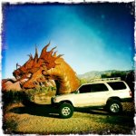
Day trip to Anza Borrego on 1/1/2012 (pics to follow)

BrianSD_42

New member
Like the title said I am heading out to Anza Borrego state park in Southern California on Sunday 01/01/2012. I will be traveling with my GF doing some site seeing.

Anza-Borrego Desert State Park - Wikipedia, the free encyclopedia

Anza-Borrego Desert SP


Can anyone recommend some easy to intermediate trails without serious rock crawling? Preferably with a good view, canyons, mines ect..

I will follow up with some pics on Monday.


Thanks!

:hatsoff:
 

Attachments

  • d44eb7a76a0518c4ff526485fc40fc4d_large.jpg
    d44eb7a76a0518c4ff526485fc40fc4d_large.jpg
    97.6 KB · Views: 1,335
Register to hide this ad
There are many fun options in Anza Borrego.

For easy/intermediate, I would recommend taking Arroyo Sin Nomber & Arroyo Tapiado up to the mud caves (from the 8). If you have never checked out the mud caves, it is a super cool trip to do with your GF. The sand/dirt roads to get up to the caves is easy, but there are numerous places where you can just goof around on banks & berms, do some small drops, and do sand donuts.

For more intermediate, the North end of the park has Sheep's Canyon. The road getting out there has three significant water crossings (third crossing is often over your tires, but I have heard they may have diverted this crossing to avoid the deep water). After the third crossing, there are three steep/loose rocky climbs. You would be fine with your big tires and locker, both of which are probably needed. After the rocky climbs, it is super fun driving around Sheep's Canyon: sandy with banked turns, wide open sand areas, some fun washes. And at the top the canyons are very impressive. Take the 67 to the park for this run.

Maybe a little beyond intermediate would be to head over to Fish Creek area, which you enter like the mud caves (Arroyo Sin Nombre). There are some steep drops and challenging terrain, and not always an easy way out.

Hope this helps!
 
I was thinking about going out to Anza on Sunday also. I'm not sure if the GF is up to it. If so, I'll let ya know. Maybe we could meet up and roll together.
 
Hey Triumph, I am in south Carlsbad. Either way we should meet up sometime since your are on T4R and live so close.
 
Last edited:
My sister lives off Poinsettia less than a 1/2 mile east of the 5. I live right near Encinitas Blvd. I'll let ya know about getting together on Sun. I should have a better idea tomorrow. What time are you planning on leaving?

Hey Triumph, I am in south Carlsbad. Either way we should meet up sometime since your are on T4R and live so close. I live off of Poinsettia exit.
 
Brian

The Canyon Sin Nombre / Arroyo Tapiado / Fish Creek area at the south end of the park is great but if you are doing a day trip from Carlsbad it will be a lot of driving just getting there and back. And days are short this time of year. Save that for later or when you can plan to camp overnight.

I'd recommend the 76 to the 79 to S22 to Borrego Springs. There is a nice overview of the desert as you come down S22. Drive around Christmas Circle, check out the town, go to the park visitor center and pick up a guide book or two if you don't already have one. Then head up Coyote Canyon to Sheep Canyon as far as you want to go. Definitely an interesting 4x4 route with the water crossings and some intermediate rock crawling but like cpepper said you won't have any trouble with your truck set up the way it is.

Jeeps, but it shows the rocky climb cpepper was talking about: Project-JK Anza Borrego Coyote Canyon Jeep Trail Run 2007 - YouTube

Have fun!
 
Coyote Canton is definitely fun, but I heard the main water crossing was modified to allow more vehicles in (i.e., easier to cross). Haven't been there in about a year, so I can't confirm.

I'm in South Escondido by the 78.

Brian

The Canyon Sin Nombre / Arroyo Tapiado / Fish Creek area at the south end of the park is great but if you are doing a day trip from Carlsbad it will be a lot of driving just getting there and back. And days are short this time of year. Save that for later or when you can plan to camp overnight.

I'd recommend the 76 to the 79 to S22 to Borrego Springs. There is a nice overview of the desert as you come down S22. Drive around Christmas Circle, check out the town, go to the park visitor center and pick up a guide book or two if you don't already have one. Then head up Coyote Canyon to Sheep Canyon as far as you want to go. Definitely an interesting 4x4 route with the water crossings and some intermediate rock crawling but like cpepper said you won't have any trouble with your truck set up the way it is.

Jeeps, but it shows the rocky climb cpepper was talking about: Project-JK Anza Borrego Coyote Canyon Jeep Trail Run 2007 - YouTube

Have fun!
 
I hit the trail this past October when it opened, and the water crossing was still there. I have read that it has been diverted in the last month though, which is really too bad, it was a cool feature.

That said, it could get pretty deep and maybe not great a idea with the OP's open-element air filter..
 
The trip was really great. We just made it home. I was racing the sun there at the end. I took some cool pics and a few videos that I will post up in a few hours.
 
***********************************************
Pics & Videos
***********************************************

I left San Diego at 9:30 and didn't get to Anza-Borrego until noon.


*** Proper packing for a day trip ***


We stopped by the visitors center to pick up some maps. I recommend everyone do this! The $10 map is much better than the cheap one they give out to most tourists.


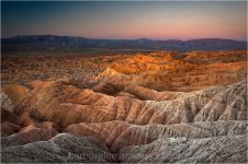
****** Font's Point ******


1.


2.


3.


---> Click for High Quality Picture Link 4000x3000 JPG


4.


---> Click for High Quality Picture Link 2915x3900 JPG


5.


---> Click for High Quality Picture Link 4000x3000 JPG


6.


---> Click for High Quality Picture Link 4000x3000 JPG
 
**** More Pictures ****


1.


2.


3.


----> Click for high quality picture 3000x4000 JPG


4.


5.


:gun6:


Note:

Somehow this thread is broken due to one of the YouTube video I embedded in post #17. I cannot see any posts after my first video on page 2. If you reply to this thread your post may not be visible.


Here are the remaining videos


*** Video 1 ***
<iframe width="853" height="480" src="http://www.youtube.com/embed/-MgSUD-vIWc" frameborder="0" allowfullscreen></iframe>


*** Video 2 ***
<iframe width="853" height="480" src="http://www.youtube.com/embed/7UpYkVocENk" frameborder="0" allowfullscreen></iframe>


*** Video 3 ***
Music by Trent Renzor
<iframe width="853" height="480" src="http://www.youtube.com/embed/MN0DA66jyw0" frameborder="0" allowfullscreen></iframe>


*** Video 4 ***
<iframe width="853" height="480" src="http://www.youtube.com/embed/dtQAg-fevcU" frameborder="0" allowfullscreen></iframe>


:reddance:
 
Last edited:
<<< Reserved for videos >>>


<iframe width="853" height="480" src="http://www.youtube.com/v/-MgSUD-vIWc&hd=1" frameborder="0" allowfullscreen>


:bat:
 
Last edited:
Great pics!

Dragons in Anza.


I drove right by that Dragon but next time I will definitely stop for some pics. We started on the trails at 12:30 and by the time we left Font's Point it was after 1:30pm. With a 5:30pm sunset approaching was in a hurry to make it through the park.
 
Next time check out Little Blair Valley! :thumb3:
I got a couple of pics in one of my albums.

Like the title said I am heading out to Anza Borrego state park in Southern California on Sunday 01/01/2012. I will be traveling with my GF doing some site seeing.

Anza-Borrego Desert State Park - Wikipedia, the free encyclopedia

Anza-Borrego Desert SP


Can anyone recommend some easy to intermediate trails without serious rock crawling? Preferably with a good view, canyons, mines ect..

I will follow up with some pics on Monday.


Thanks!

:hatsoff:
 
I drove right by that Dragon but next time I will definitely stop for some pics. We started on the trails at 12:30 and by the time we left Font's Point it was after 1:30pm. With a 5:30pm sunset approaching was in a hurry to make it through the park.

We were on the trail at 8am. We went up Coyote Canyon, Sheep Canyon, then headed south to Indian Canyon. I wanted to do Pinyon Trail, but I was told it is deffinitly not a 1 truck trail. From what I understand "The Squeeze" and "The Dropoff" are pretty knarly. And once commited....you're commited.
Great pics!!! I look forward to doing a run together sometime. I saw so many Jeep groups runnin the trails yesterday. Sometime we'll have to get a group of Yotas together.
 

Members online

No members online now.

Forum statistics

Threads
278,315
Messages
3,554,130
Members
248,016
Latest member
Advally Service

Trending content

Back
Top