

TheSentinel
New member
OCTOBER MEET UP AND TRAIL RUN
The run will be on Saturday, the 17th. We will be traversing the San Jacinto Mountain Range.
Difficulty: **UPDATE** Most likely medium due to recent rain storms.
Organizer(s): TheSentinel (Jason)
Trail Leader(s): 85straight (Al)
Meet Location:
Santa Rosa Fire Station
47015 California 74, Hemet, CA 92544
Ranger Station Mapped Out
This ranger station is directly off of Hwy 74, proceed East on Florida Ave until you pass orange groves, shortly after, you will see the ranger station to your right.
*Remember to fuel up and grab a bite to eat before heading out*
Route:
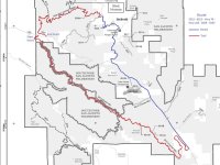
5S15 Rouse Hill to 6S13 Thomas Mountain - Blue Square – More Difficult (Verified 9/29/15)- 29.8 Miles
Once at 74, proceed NW, turn right onto 243 to Idyllwild where we will meet for lunch
5S09 San Jacinto Ridge Rd to 5S07 Bee Canyon - Blue Square – More Difficult (Verified 9/29/15)- 15.5 Miles
Optional higher difficulty group:
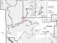
4S21 Indian Mountain - Black Diamond - Most Difficult (Verified 9/29/15)
Bee Canyon thread with picture from Sept. 6th
Meeting time(s):
1. 9:00AM at the Santa Rosa Fire Station for Safety and Trail Meeting leaving for trail head immediately after. Please arrive prior to 9:00AM, I will be there NLT 8:30AM. Departure should be NLT 9:15AM
CB Channel/ FMRS Chanel:
13/13
Tentative Roster:
1. TheSentinel (Organizer)
2. Tronn
3. Oneluv13T4R
4. TK-422
5. 85straight (Leader)
6. Davy180
7. WFO Racer
8. masson74
9. 470SNC
10. LMR
11. Drunner97
12. Logan714
13. Dezert4Runner
14. BrianSD_42
15. e-caban
16. 98WhiteT4R
If I have missed anyone, please PM me and I'll add you to the list. I would like to verify our numbers before heading out. If you want off the roster, let me know in a PM.
What to bring with you:
Good Attitude - This group is big...we'll need to be patient with each other
Snacks, food, beverages (no alcohol consumption en route please)
$ for a meal afterwards (preferably cash in case they wont split check)
Spare fluids for vehicle
Recovery gear if you have it.
Recovery point front and rear (factory hook is fine)
Description: Begin on Rouse Hill truck trail (5S15) on Hwy 74 and follow to/through Thomas Mountain. From the staging point, elevation will increase from 1900' to 5550' at the end of Rouse. The trail ends up back on 74 headed west (about 2 hrs give or take depending on speed). Then head toward Idyllwild (about 25 minutes of pavement). After meetup at the top, get onto Bee Canyon (5S09/5S07) in Pine Cove and head back down the mountain. Half way down is where the turn off for Indian Mountain is.
Those continuing on Bee Canyon will end close to our start on the 74.
4S21 Indian Mountain Info:
I have confirmed that it is a black diamond. "It is very similar to 2N17X, except much narrower. 4S21 starts on the high side at Hwy 243 at the Indian Vista N33.79700 W116.77794 and on the low side on 5S09 at N33.7676 W116.7894"
San Jacinto
Length: 3.75 miles. Time to complete: 1 hour.
4S21 can be found in the San Bernardino National Forest in the San Jacinto area. 4S21 is available to all Off Highway Vehicles. 4S21 has been adopted by the Hemet Jeep Club.
The US Forest Service rates this trail a blue square more difficult route. On 4S21 you can expect to encounter narrow shelf roads with tight switchbacks and old firebreaks running on ridges. You can expect to encounter deep ruts. Elevation ranges from 4700' to 5790'.
San Bernardino National Forest - Home
San Jacinto Mountains Map
http://www.fs.usda.gov/Internet/FSE_DOCUMENTS/stelprdb5202572.pdf
San Jacinto Ranger Station: (909) 382-2921
San Bernardino National Forest Supervisor's Office: 909-382-2600
Note: This doesn't mean that we can't have a second meet up, or third for that matter, the same month. I would really like to see our SoCal club get active again, with organized monthly runs/meetings. I am also of the mindset that in order to include the most members, we should have an easy run and a more difficult run. I will update this post as we work out the details.
As always, I am open to all suggestions and comments.
Main Route:
Indian Mountain (Optional):
The run will be on Saturday, the 17th. We will be traversing the San Jacinto Mountain Range.
Difficulty: **UPDATE** Most likely medium due to recent rain storms.
Organizer(s): TheSentinel (Jason)
Trail Leader(s): 85straight (Al)
Meet Location:
Santa Rosa Fire Station
47015 California 74, Hemet, CA 92544
Ranger Station Mapped Out
This ranger station is directly off of Hwy 74, proceed East on Florida Ave until you pass orange groves, shortly after, you will see the ranger station to your right.
*Remember to fuel up and grab a bite to eat before heading out*
Route:
5S15 Rouse Hill to 6S13 Thomas Mountain - Blue Square – More Difficult (Verified 9/29/15)- 29.8 Miles
Once at 74, proceed NW, turn right onto 243 to Idyllwild where we will meet for lunch
5S09 San Jacinto Ridge Rd to 5S07 Bee Canyon - Blue Square – More Difficult (Verified 9/29/15)- 15.5 Miles
Optional higher difficulty group:
4S21 Indian Mountain - Black Diamond - Most Difficult (Verified 9/29/15)
Bee Canyon thread with picture from Sept. 6th
Meeting time(s):
1. 9:00AM at the Santa Rosa Fire Station for Safety and Trail Meeting leaving for trail head immediately after. Please arrive prior to 9:00AM, I will be there NLT 8:30AM. Departure should be NLT 9:15AM
a. Dave Bentley, Assistant Manager of OHV with San Bernardino National Forest has offered to speak to us briefly on volunteering opportunities and may join us on the run.
2. 12:00PM Lunch! All are welcome to join us @ The Lumber Mill Bar & Grill 25985 State Highway 243, Idyllwild, CA 92549 MapNote: There will be time to do some walking/shopping in downtown Idyllwild (they are dog friendly there)
3. 3:00PM meet at gas station at intersection of Pine Cove Rd and 243 for a 3:15PM departureCB Channel/ FMRS Chanel:
13/13
Tentative Roster:
1. TheSentinel (Organizer)
2. Tronn
3. Oneluv13T4R
4. TK-422
5. 85straight (Leader)
6. Davy180
7. WFO Racer
8. masson74
9. 470SNC
10. LMR
11. Drunner97
12. Logan714
13. Dezert4Runner
14. BrianSD_42
15. e-caban
16. 98WhiteT4R
If I have missed anyone, please PM me and I'll add you to the list. I would like to verify our numbers before heading out. If you want off the roster, let me know in a PM.
What to bring with you:
Good Attitude - This group is big...we'll need to be patient with each other
Snacks, food, beverages (no alcohol consumption en route please)
$ for a meal afterwards (preferably cash in case they wont split check)
Spare fluids for vehicle
Recovery gear if you have it.
Recovery point front and rear (factory hook is fine)
Description: Begin on Rouse Hill truck trail (5S15) on Hwy 74 and follow to/through Thomas Mountain. From the staging point, elevation will increase from 1900' to 5550' at the end of Rouse. The trail ends up back on 74 headed west (about 2 hrs give or take depending on speed). Then head toward Idyllwild (about 25 minutes of pavement). After meetup at the top, get onto Bee Canyon (5S09/5S07) in Pine Cove and head back down the mountain. Half way down is where the turn off for Indian Mountain is.
Those continuing on Bee Canyon will end close to our start on the 74.
4S21 Indian Mountain Info:
I have confirmed that it is a black diamond. "It is very similar to 2N17X, except much narrower. 4S21 starts on the high side at Hwy 243 at the Indian Vista N33.79700 W116.77794 and on the low side on 5S09 at N33.7676 W116.7894"
San Jacinto
Length: 3.75 miles. Time to complete: 1 hour.
4S21 can be found in the San Bernardino National Forest in the San Jacinto area. 4S21 is available to all Off Highway Vehicles. 4S21 has been adopted by the Hemet Jeep Club.
The US Forest Service rates this trail a blue square more difficult route. On 4S21 you can expect to encounter narrow shelf roads with tight switchbacks and old firebreaks running on ridges. You can expect to encounter deep ruts. Elevation ranges from 4700' to 5790'.
San Bernardino National Forest - Home
San Jacinto Mountains Map
http://www.fs.usda.gov/Internet/FSE_DOCUMENTS/stelprdb5202572.pdf
San Jacinto Ranger Station: (909) 382-2921
San Bernardino National Forest Supervisor's Office: 909-382-2600
Note: This doesn't mean that we can't have a second meet up, or third for that matter, the same month. I would really like to see our SoCal club get active again, with organized monthly runs/meetings. I am also of the mindset that in order to include the most members, we should have an easy run and a more difficult run. I will update this post as we work out the details.
As always, I am open to all suggestions and comments.
Main Route:
Indian Mountain (Optional):
Attachments


Last edited:


