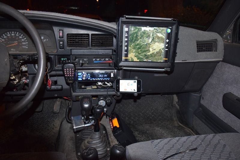
Offroad gps?

Checkout Offroad Trail Guide in the App Store. It's designed by a fellow T4R member for exactly what we do. He's always looking for feedback and has some fantastic features planned for 2017.


Sent from my iPhone using Tapatalk

Subscribed. I wish I had this over Thanksgiving week when I was in Vegas, looking to get outside. I hiked Sloan Canyon and drove through Red Rocks Canyon but didn't find any trails other than the [unnecessary] back road to Sloan Canyon.
 
Offroad GPS

I've been using GPS offroad since 1997, mostly on offroad bikes. The tech has certainly come a long way.

I always carry a personal locator beacon, here's a good one for about $235.

I like the dedicated GPS units because they are more durable. Lately I have been using the Garmin Montana series with Garmin's 24K Topo maps which are routable. I just picked up Garmin's new GPSMAP 276Cx. Nice unit but pricey at $800.

The Lowrance Baja unit has been the go to unit for serious 4x4 competition, hence the name. It's a big unit and will require some special mounting in the 4runner.

I like the Motion-X software for the iPad which allows you to load down all the map content so no cell signal is required. I use the Co-Pilot iPad/iPhone software for street navigation. I need to find a good mounting solution for the iPad.

Safe travels!
 
I've been using a SPOT tracker, but will probably switch to InReach. The SPOT will allow others to see your tracks and allow you to send generic messages and a SAR request, but you can't receive messages.


Sent from my iPhone using Tapatalk
 
Adding to discussion - inreach (deLorme) was recently acquired by Garmin. This may be good news, because the user interface on the inreach sucks.

Their mapping app (linked via bluetooth) is very good. They have different plans - I had an unlimited plan that was about $60/month. I sent it with my son who was truly off the grid in Tierra del Fuego.

I now have the 12/month plan, which is limited, but all I need. Look at cell coverage maps. Some of the biggest gaps are in Eastern Oregon, where I work and play. My wife, in particular, loves that I have it.

I used to have a SPOT, but switched for the 2 way comms and useable GPS.
 
on the same subject, what do ya'll do if you have no cell service off-road and have an emergency phone call to make to family?


Wilson Electronics cellphone booster. They have changed their name to Weboost. Prices have trended upwards over the past two years. I'll link to a single device booster. However, I normally use a 4 device booster that's also stronger. Your cellphone normally has an output signal capped at .25 watts. The single booster is about 1.8 watts. The big 4 device booster is 3watts. The booster is not Magic. Some areas still have no signal. These dead zones are significantly decreased. Verizon, Sprint and US Cellular see a little better improvement than AT&T and T-MOBILE. CDMA 1x and 3g vs GSM.

With the booster I have call and data when others have zero signal. I can stream Pandora when others have nothing.

Google maps on Android supports offline maps (free).


Wilson booster on Amazon
 
Had an Iridium sat phone back in 2006. Used it to stay in touch with family on an expedition in Peru way up the Amazon when we were two days boat ride from what anyone would call a town. Needed it again in Sierra Leone to call Global Rescue when our driver had a stroke up country after an animal strike. In an international emergency there is no substitute for a sat phone. Now that those days are behind me I'm good with ham radio, but want to add an inReach for those annoying dead zones.


Sent from my iPhone using Tapatalk
 
What kind of gps unit you guys use for off-roading? My phone and the car gps simply doesn't work in the wild.


Sent from my iPhone using Tapatalk

I've been using MotionX GPS for a few years on both my iPhone and iPad and like it. Has the ability to upload offline maps (both terrain and sat), import/export routes and waypoints etc.
 
I like the Motion-X software for the iPad which allows you to load down all the map content so no cell signal is required. I use the Co-Pilot iPad/iPhone software for street navigation. I need to find a good mounting solution for the iPad.

Safe travels!

This. The iPad's GPS receiver gets a signal even if there's no cell coverage.

Ideally, I'll figure out an ad hoc mounting solution I can use while off-roading but remove otherwise since that's the only time I'm using the iPad in the truck.
 
MotionX on an iPad has worked for me for years . A good mount is also very useful....

DSC_0003_zpsdits2cvu.jpg~original
 
Last edited:
I have an older Delorme hand-held GPS receiver from my Geocaching days, but it eats batteries. For pure rugged GPS use nothing beats a good hiking model. Garmin makes some really good ones.


Technically, there's nothing wrong with your phone's GPS receiver. The GPS satellites are up there, so it will work if you can see the sky. The problem is with downloading maps in areas with no data access.

If you have an Android, I used to love the Back Country Navigator app. I used it for years. Pre-download maps for any area where you won't have data coverage. I haven't used it in years, though, so I can't vouch for its current version.

If iPhone, I now use Avenza's PDF Maps. You can pre-download USGS quad maps for free, or pay to download various commercial maps. Some are quite good. I was able to download free USCOE navigation maps for the local lakes and rivers for boat use last summer. If you have the skills and software, you can even create your own geolocated PDF maps.

I recently bought the Gaia GPS app (father's day present). I haven't had much opportunity to use it, but the few times I have used it I loved it. Lots of people have uploaded trails and tracks, so you can get info on where to go even if your road isn't on the map.


Keep in mind that you can't auto-navigate with these off-line maps. Think of them as raster paper maps. The GPS receiver will tell you where you are on the map, but you'll have to read it to figure out where to go.

 
Last edited:
I think motion x it is


Sent from my iPhone using Tapatalk

Can you put it on the iPhone


Sent from my iPhone using Tapatalk

I use MotionX on both my iPad and iPhone. Both have advantages/disadvantages. With my iPad, I use a floor mount RAM with X-grip. For my iPhone, I use a Kenu Airframe. Advantages for iPad is size of display, Advantages for iPhone is portability. I often go to a viewable site/hiking. With my iPad, I remove it and put it under the seat. With my iPhone, I take it with me. The iPhone requires a lot of scrolling/zooming. Try both to see what fits your model best.

Another thing to consider is the power consumption. The iPad draws close to or more than the standard 0.5/1 amp USB charging plug in-adapter. I use a 3 port 2.1 amp cigarette lighter. This allows me to run both iPad, iPhone, and wife's iPhone as needed.
 
Another vote for Gaia GPS. I do a lot of backpacking and this app is great for trails and cross country.
 
This. Lowrance in my boat and love it, don't use/need it enough for my off-road truck so backcountry gets it done. Tablets are cheap, ram mount and backcourt app FTW.

I had a lowrance Baja 540c in my FJ - awesome unit, but they didn't keep it updated with maps. Bought Mapcreator 7 to use with it and after one update they stopped supporting it.

I had it mounted in the storage compartment in front of the driver. Was perfect for off road use as I didn't have to do anything other than glance down to see it.


Garmin seems to provide better support for their units, but Lowrance had the better display.

I think, for me, the best solution will be a tablet with a GPS antenna and good software.
 

Members online

Forum statistics

Threads
278,307
Messages
3,554,049
Members
248,016
Latest member
Advally Service

Trending content

Back
Top