Six-Function Dashboard Instrument, Altitude compass reader

Brookey_813

New member
I've been looking into finding something like this below that I can have on my dash for measuring the altitude and also can tell me my direction of travel. Does anybody have something like this installed already? If so, where did you buy it and where did you place it in your 4Runner?
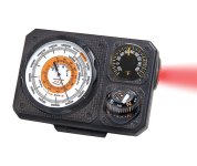
4cba74_4949d2df99d6423fb0f7022553b2e257.jpg

Backpacking and Hiking Equipment Made in USA

 

Attachments

  • 4cba74_4949d2df99d6423fb0f7022553b2e257.jpg
    4cba74_4949d2df99d6423fb0f7022553b2e257.jpg
    90.8 KB · Views: 2,519
Register to hide this ad
I've been looking into finding something like this below that I can have on my dash for measuring the altitude and also can tell me my direction of travel. Does anybody have something like this installed already? If so, where did you buy it and where did you place it in your 4Runner?
View attachment 249526

Backpacking and Hiking Equipment Made in USA

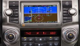
Sorry can't help, I've looked myself to no avail. I personally can't believe there's not an option to include the altitude on the Nav page, that would personally solve the problem for me. (and for an external unit I'd lose the thermometer for an inclinometer, given my druthers).
 
Last edited:
I know the GX had the altimeter and it was horribly inaccurate. GX forums are full of people complaining. I'm guessing that's why Toyota doesn't include it anymore.

I use my phone as well with this app...
https://goo.gl/e7Itdw

Sent from my SM-G950U using Tapatalk
 
I've been looking into finding something like this below that I can have on my dash for measuring the altitude and also can tell me my direction of travel. Does anybody have something like this installed already? If so, where did you buy it and where did you place it in your 4Runner?

Your dash already tells you the direction of travel
 
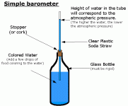
Altitude indicators are really barometers with a different scale - so you could make your own if you wanted. Instead of a full glass cockpit I suggest an ISI - integrated standby instrument. It will give you altitude, attitude, airspeed / ground speed that comes alive at 60mph along with ILS info. They are a bit pricy though!
 
Altitude indicators are really barometers with a different scale - so you could make your own if you wanted. Instead of a full glass cockpit I suggest an ISI - integrated standby instrument. It will give you altitude, attitude, airspeed / ground speed that comes alive at 60mph along with ILS info. They are a bit pricy though!

I just use this:
 

Attachments

  • simple_barometer.gif
    simple_barometer.gif
    7.9 KB · Views: 1,778
My watch does all of that stuff...get a good Frogman or equivalent watch and you can find all of that info and then some.
 
What map app is that? I keep trying to find one I love, each has fallen short so far.

Currently running Gaia with the Pro annual membership. I think they all have limitations, Gaia has been the best for me so far. App itself is awesome, as is the snap to trail interface for planning routes through their website. If you do a lot of trails the upgrade to Pro is worth it. I can run multiple map layers and change transparency on each layer through the app.

If you have Gaia and don't have Pro, I can give you a code for a free year.
 
Last edited:

Members online

Forum statistics

Threads
278,307
Messages
3,554,050
Members
248,016
Latest member
Advally Service

Trending content

Back
Top