
The K-Trail

kingofthehill

New member
I want to know more about this trail. I want to know if it is a viable option for a trip. I have been reading a lot of conflicting information online about how part of the trail is on private land. I cant determine what part is considered private. Google maps sees the whole trail as a public road. Some people say it is good from Clayton to the Indian highway, some say that it is private land from Clayton to three sticks. Others have said it is not private at all and some people who own land off of it are harassing people because they think it is theirs. So does any one have any ideas what the truth is about this trail. I would like to gather as much info on it before trying any part of the trail out.

https://www.overlandbound.com/forums/threads/k-trail-clayton-ok.11647/

Important posts: 3 (states it is good from Clayton to Three sticks), 10 (exact opposite of post 3), 13, and 15.
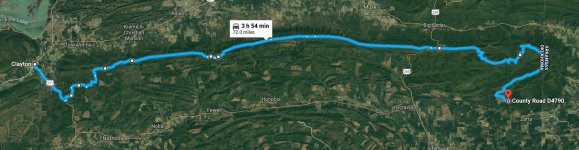
 

Attachments

  • Google maps K-trail.jpg
    Google maps K-trail.jpg
    132.6 KB · Views: 1,044
Register to hide this ad
Don't go west of the firetower

Where is firetower exactly along the trail? I keep reading about it but I haven't been able to locate it on google maps satellite view.

What about the Honobia Trail to K-trail. It seems to intersect shortly before Three sticks. From the information that I found Firetower is just a little ways west of three sticks.

Lastly, I recently read the part that is private on K trail is from 9 pines road to firetower. 9 pines doesn't cross the K trail. It crosses the Clayton trail, which is the more popular route to get to the K trail. Does that mean there are other routes from Clayton area that are legal to run?

Edit:
There is a lot of misinformation and I would like to find the truth. Here is an article written in USA today from early 2018 that states nothing about any closures on the K trail.

https://traveltips.usatoday.com/offroad-trails-clayton-oklahoma-111926.html
 
Last edited:
Yup it's just west of 3 sticks, although I can't seem to find it on Google maps either....

If you're on Facebook there are some more knowledgeable people in the "overland" groups - Texas Overland, DFW Overland.


Sent from my iPhone using Tapatalk
 
I have been searching and I think I found the coordinates to the Kiamichi Trail firetower. They may not be right but I think they are correct. The google maps sattalite view shows what looks like a structure at that point and it appears to be at the peak of a mountain in the kiamichi range.

34.62651, -94.81220

I am going to try and drive the K-Trail From east to west ending at the Firetower in a couple weeks when I go camping.
 
I have been searching and I think I found the coordinates to the Kiamichi Trail firetower. They may not be right but I think they are correct. The google maps sattalite view shows what looks like a structure at that point and it appears to be at the peak of a mountain in the kiamichi range.

34.62651, -94.81220

I am going to try and drive the K-Trail From east to west ending at the Firetower in a couple weeks when I go camping.

Ok, now that I put in perspective it looks familiar - I camped in that spot, closer to the garage structure, about 3 years ago when we were able to run east to west, from Clayton, OK.
 
Ok... I didn't know if thats where the private land started, if the 'squatch lived back there, or would enter Narnia... It was a legitimate question.
 
quote from a source

From what I told first hand by Dane Cook, the game warden for that county, anything West of 3 Sticks (aka Hwy 259) that isn’t in the National Forest including the fire tower is off limits. Indian highway east entrance is still accessible but 100% off limits. To make it easy as one other person was saying, run K Trail East of 259 and you will be fine. Remember it is close to hunting season up there and hunters will be in that section of KTrail as well so be respectful of them too.
 
quote from a source

This is the first Im hearing of the firetower being off limits. everything I found said that the firetower is as far west. It somewhat makes sense it apears that the fire tower if several miles as the crow flies beyond the border of the Ouachita national forest.

I tried to run the K-trail today on my way home from camping in the Ouachitas. Had to cut our trip early due to weather. By the time were approaching three sticks It was raining so hard that hydroplaning was becoming an issue. Ill probably wait for a weekend that has good weather and try to get up there and run the legal part of the K-trail. It is only about a 2hr 45 min drive from my house to three sticks.
 

Members online

Forum statistics

Threads
278,307
Messages
3,554,054
Members
248,016
Latest member
Advally Service

Trending content

Back
Top