
Wheeling and Camping Oct 8-9th

I'm not sure that it has to be... but I did have [MENTION=102715]CrazyNorwegian[/MENTION] take care of mine on a run.

Sent from my SAMSUNG-SM-G890A using Tapatalk

I was able to get channel 13 and then the frequency also from the first post so I think I'm good.
 
[MENTION=134386]jetblack3s[/MENTION] [MENTION=140577]ChrisLe777[/MENTION] [MENTION=117408]Oneluv13T4R[/MENTION] If you guys don't mind and are camping in Big Pine flats, I would greatly appreciate dropping some camping gear to lessen the weight when we hit white mtn trail. I don't like to be that loaded when offroading. I'll pick it up on the way back. Let me know.

Well I'm gonna have to disagree with [MENTION=134386]jetblack3s[/MENTION] ...I say hell no! F that !! Keep your shiiit loaded down and kick rocks ...sucka.


:::jk:
Miah
 
I was able to get channel 13 and then the frequency also from the first post so I think I'm good.

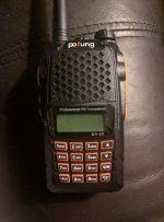
Lol ...we don't run on 13 on ham radios that's for CB radios. Which your handheld has both CB and ham. Ham we run 146.460 and I know right now you're like what the F is that how do you get that frequency?
No worries ree ree I will take care of it for you in the morning meet up and program it for you ...you can rest easy now.

Miah
 
so i think we have a plan for a run on saturday. any plans for sunday or monday?

i was thinking one of the days, i'm gonna leave the truck at camp and go for a hike.

Yeah, that's why I bought my 4Runner and modified it to get me to places in the mountains just .....so I don't have to hike .
Sunday I'm gonna wheel some of the other blue rated trails I have not done before which are the last ones in the big bear area for me to complete and know what they have to offer ..
 

Attachments

  • IMG_20161006_215902.jpg
    IMG_20161006_215902.jpg
    135.4 KB · Views: 149
Lol ...we don't run on 13 on ham radios that's for CB radios. Which your handheld has both CB and ham. Ham we run 146.460 and I know right now you're like what the F is that how do you get that frequency?
No worries ree ree I will take care of it for you in the morning meet up and program it for you ...you can rest easy now.

Miah
We were running the 13.1 or whatever it was on FRS for a minute in Cleghorn. That was the one that required some programming.

Sent from my Nexus 6 using Tapatalk
 
Yeah, that's why I bought my 4Runner and modified it to get me to places in the mountains just .....so I don't have to hike .
Sunday I'm gonna wheel some of the other blue rated trails I have not done before which are the last ones in the big bear area for me to complete and know what they have to offer ..
I might try to hook up Sunday. What's your route? I'll have to drop Robbie in highland by 11 and then I can be in green valley by 1130-12 from there I should be able to pick up dirt to find you guys. Just have to be headed back down by 4-5 To pick the little man back up. It's unfortunate my ex is a ****up because I used to have more Sunday time but I had to knock that shit back.

Sent from my Nexus 6 using Tapatalk
 
I threw out jacoby canyon 3n61 to the squeeze to 3n16. But I think [MENTION=117408]Oneluv13T4R[/MENTION] has something in mind as well. I'm good with consensus.

Sent from my SM-G930P using Tapatalk

I have 2 route ideas ... which will consist of blue rated trails except for a couple green rated connecting trails between each blue trail.

Route 1
3N84 (Blue) > 3N08 (Blue) > 2N84 (Blue) > 2N84A (Blue) > 2N84B (Blue) > 3N12 (Green) > 3N16 (Green) > 3N19 (Blue) (which goes through the Pinnacles Rock Climbing Area) > 3N32 (blue/green) > 3N10 (the main event and final section of this planned route) its known as "lil John Bull" it is the last section of big John Bull trail but is blue rated and known as lil John Bull.

Route 2
This one is more straight forward

3N61 Jacoby Canyon (Blue) in reverse starting with "the Squeeze " > cross Hwy 18 to 2N02 Burns Canyon (Green) > 2N90 Tip Top Mountain (reward is amazing views (photos) and a couple mines ...but not for anyone who isn't comfortable on narrow rocky trail on the edge of a mountain all the way up) or drive pass tip top Mtn to the next left > Rattlesnake Canyon (Blue rated) known for killer canyon walls and a mix of different sections (photo opportunities) throughout the trail turning into a super soft sand wash where you can let her rip to to the finish where it will then end at the Hwy to air up for home ...
 
I just my Pofung CB in. Do I need to program it or is it good to go out of the box? I got the USB cable and mini cd with it.

Don't use the mini cd. Download a free application on your computer called chirp. Very easy to use. There are also plenty of videos online on how to program it without software. We don't use tones or offset frequencies on the trail so it will be pretty strait forward
 
I have 2 route ideas ... which will consist of blue rated trails except for a couple green rated connecting trails between each blue trail.

Route 1
3N84 (Blue) > 3N08 (Blue) > 2N84 (Blue) > 2N84A (Blue) > 2N84B (Blue) > 3N12 (Green) > 3N16 (Green) > 3N19 (Blue) (which goes through the Pinnacles Rock Climbing Area) > 3N32 (blue/green) > 3N10 (the main event and final section of this planned route) its known as "lil John Bull" it is the last section of big John Bull trail but is blue rated and known as lil John Bull.

<iframe width="560" height="315" src="https://www.youtube.com/embed/SkTwgMsGjDM" frameborder="0" allowfullscreen></iframe>

this "lil" john bull???
 
Is anyone else going to go up Friday or will it be just me?


I am planning on being there Friday around 8pm at big pine flat campground and try to hold couple spots for others that will be arriving the following day


Sent from my iPhone using Tapatalk
 
<iframe width="560" height="315" src="https://www.youtube.com/embed/SkTwgMsGjDM" frameborder="0" allowfullscreen></iframe>

this "lil" john bull???

I guess so ...I have never been there to confirm but that would seem about right I was thinking it would be a bit more than that ...if you have ever seen or done "John Bull" makes that look like a gravel road. Hahaha


But to be completely honest with you ...that is very easy. The driver in that video drives like a complete idiot you can tell he has no idea what he was doing he didn't ever touch the brake to ease himself down anything cause he was afraid to get stuck ...classic newbie/ rookie move you see that a lot. and his spotters were just shoot the shit with each other with no care at all and laughing just letting him continue to break something ...not cool.
 
Last edited:
I have 2 route ideas ... which will consist of blue rated trails except for a couple green rated connecting trails between each blue trail.

Route 2
This one is more straight forward

3N61 Jacoby Canyon (Blue) in reverse starting with "the Squeeze " > cross Hwy 18 to 2N02 Burns Canyon (Green) > 2N90 Tip Top Mountain (reward is amazing views (photos) and a couple mines ...but not for anyone who isn't comfortable on narrow rocky trail on the edge of a mountain all the way up) or drive pass tip top Mtn to the next left > Rattlesnake Canyon (Blue rated) known for killer canyon walls and a mix of different sections (photo opportunities) throughout the trail turning into a super soft sand wash where you can let her rip to to the finish where it will then end at the Hwy to air up for home ...

This one sounds fun.. especially doing tip top mtn. Rattle snake canyon ends at the 247?
 
This one sounds fun.. especially doing tip top mtn. Rattle snake canyon ends at the 247?

Yeah out the back of big bear ...but it's a clear straight hwy. guaranteed I could go out the back and around to the front faster than anyone going out the front and down the 330 with every other person that came up to big bear for the weekend, it's always a cluster fuk on the weekends to head home ...
 
At this time I will plan on trying the northern route thru Apple Valley - Lurcene on the 18 then down to Big Bear. I haven't gone that way before. I should be at camp around 4pm in Serrano.
 
I guess so ...I have never been there to confirm but that would seem about right I was thinking it would be a bit more than that ...if you have ever seen or done "John Bull" makes that look like a gravel road. Hahaha


But to be completely honest with you ...that is very easy. The driver in that video drives like a complete idiot you can tell he has no idea what he was doing he didn't ever touch the brake to ease himself down anything cause he was afraid to get stuck ...classic newbie/ rookie move you see that a lot. and his spotters were just shoot the shit with each other with no care at all and laughing just letting him continue to break something ...not cool.

Even my weenie ass would make it down better lol
 
Yeah out the back of big bear ...but it's a clear straight hwy. guaranteed I could go out the back and around to the front faster than anyone going out the front and down the 330 with every other person that came up to big bear for the weekend, it's always a cluster fuk on the weekends to head home ...
Good route out of big bear on a weekend is skyline to Clark's grade to 2n06 (or 09? I have it GPSd) to the 38. You don't end up as far east as the 247.

Sent from my Nexus 6 using Tapatalk
 

Members online

Forum statistics

Threads
278,312
Messages
3,554,086
Members
248,016
Latest member
Advally Service

Trending content

Back
Top