who wants to go wheeling?

I haven't done those as I'm pretty new to 4 wheeling. There is a pretty cool book with all the trails in it in AZ. Been meaning to get one. You can also drive up and over 4 peaks. That's pretty easy and at the top it's nice and cool pine forest. Have to get a Tonto pass if you want to stop though.

I suppose it boils down to how badly you want to get out of the frying pan.
 
Hey actually couple more....

What about:
New River
Bloody Basin
or
sheeps bridge

???

Those are all prety mellow trails and if you wanted to, you can do connect them all into a single trip. Depending on which side of town you're coming from, you can start the trail from the 7 Springs area over by Bartlett, head north until that trail deadends at Bloody Basin - make a right to get to the Sheep Bridge. when you're done there turn around and head back - you can keep going past where you came from to take Bloody Basin all the way to the 17, or you can go back the way you came and make the right to get on New River, then take that out to the 17. Last time I went that way, we got on New River off the 17 at Table Mesa Rd, took that to Camp Creek, headed north till it ended at Bloody Basin, checked out the Sheep bridge, then took Bloody Basin out to the 17 and stopped at Rock Springs Cafe for some pie!

Like @AZ_bud mentioned, you need to pick up the Funtreks book that has a bunch great AZtrails in it:

4x4 and SUV Books : Guide to Arizona Backroads & 4WD Trails (2nd Edition) Cover Price: $34.95

 
Ohhh! I think I just stumbled on an idea!

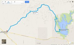
Tell me if you guys know of any weird surprises that may prevent me from doing this please, but we are planning on hitting up lake pleasant I think maybe Thursday and assuming that Castle road is as "Driveable" as it seems, would be so sweet to take that from morristown into the back/north side of lake pleasant! Seems like it would be an AWESOME drive.

???


.
 
Dude I need someone to take me out on these one day to just get my barrings lol, I keep looking at google maps and it looks like there's a MILLION forks or turns I could take on accident to get way turned around Hmmmf

But for the meantime... I'm super stoked about taking castle hotsprings rd out to lake pleasant like I mentioned assuming no surprises. Seems like a super chill/fun/scenic drive while making lunch a destination :-D


Those are all prety mellow trails and if you wanted to, you can do connect them all into a single trip. Depending on which side of town you're coming from, you can start the trail from the 7 Springs area over by Bartlett, head north until that trail deadends at Bloody Basin - make a right to get to the Sheep Bridge. when you're done there turn around and head back - you can keep going past where you came from to take Bloody Basin all the way to the 17, or you can go back the way you came and make the right to get on New River, then take that out to the 17. Last time I went that way, we got on New River off the 17 at Table Mesa Rd, took that to Camp Creek, headed north till it ended at Bloody Basin, checked out the Sheep bridge, then took Bloody Basin out to the 17 and stopped at Rock Springs Cafe for some pie!

Like @AZ_bud mentioned, you need to pick up the Funtreks book that has a bunch great AZtrails in it:

4x4 and SUV Books : Guide to Arizona Backroads & 4WD Trails (2nd Edition) Cover Price: $34.95
 
Dude I need someone to take me out on these one day to just get my barrings lol, I keep looking at google maps and it looks like there's a MILLION forks or turns I could take on accident to get way turned around Hmmmf

But for the meantime... I'm super stoked about taking castle hotsprings rd out to lake pleasant like I mentioned assuming no surprises. Seems like a super chill/fun/scenic drive while making lunch a destination :-D

There are a bunch of little turn offs and forks, but if you stay on the main trails you'll be fine. But I do recommend that you never go wheeling alone - always have at least 1 other vehicle with you, for safety's sake.

Castle Hot Springs can get a little rough in some spots. Its been a few years since I have been out there, but from what I remember, it is rougher in spots than all the trails you mentioned (Bloody Basin, New River, Sheep Bridge) depending on how far west you take it. Last time I took CHS, we went from Lake Pleasant to Wickenburg; and the further west you go, the more difficult it gets.

I'm always down to go wheelin - I know some pretty cool side trails to check out off Bloody Basin that have pretty cool sights, like the old dairy farm:


The Sheep Bridge:


and I've been told there is a hot spring under the bridge somewhere - I haven't been out there since I was told that - need to plan a trip out there to find it!
 
as far as I know table mesa has been closed due to some nasty erosion, there is a 10 foot drop off right in the middle of the trail thatb is unpassable, unless you have a bulldozer to fill it in.
 
Hmmmm....

Damn I'd really like to go drive Castle hot springs next week. To your comment about how far west, we are actually only planning on jumping on at morristown, and taking it North East up to lake pleasant, so we wouldn't be super far west on it?
 
For reference this is actually what I was looking at.
 

Attachments

  • Castlehotsprings.jpg
    Castlehotsprings.jpg
    93.9 KB · Views: 194
So, I have a day available on August 15th and want to go hit a trail. Figured I would throw this out there for planning and recommendations! Whos in?
 
Last edited:
as far as I know table mesa has been closed due to some nasty erosion, there is a 10 foot drop off right in the middle of the trail thatb is unpassable, unless you have a bulldozer to fill it in.

Last I heard at the BLM volunteer meeting is that Table Mesa is still closed on the west side of the 17 only. Technically, the east side is referred to New River trail in the 3 trail books I have.

For reference this is actually what I was looking at.

That is the CHS loop in the trail books I have - there is a spot somewhere towards the northern most part of the loop that continues west instead of heading south that can be taken all the way to the Hassayampa wash in Wickenburg

So, I have a day available on August 15th and want to go hit a trail. Figured I would throw this out there for planning and recommendations! Whos in?

I should be available to hit some dirt on the 15th. What did you have in mind? maybe this is a good time to check out New River trail/Sheep Bridge/Bloody Basin
 
Last minute butch jones run

Im meet some co workers and we are going to butch to wheel and hang out at cove 5 all are welcome
 
How far or long is cove 5 from the start? I always end up at cove 1 cause I don't know where the heck in going. Anyone have a map of how to get to the others.
 
Yea man, thats the path I'm really hoping to get on this coming weekend to just cruise and see some of the countryside. Friends get in town on Wednesday and my weekend starts thursday so really looking forward to poking around a little up there.

That is the CHS loop in the trail books I have - there is a spot somewhere towards the northern most part of the loop that continues west instead of heading south that can be taken all the way to the Hassayampa wash in Wickenburg
 
Sooo, there is going to be a Blue Moon this Friday - I think we should plan a night run somewhere - maybe something fairly easy so the newer guys can come out and have fun too; like 4 Peaks or we could check out Butcher Jones area, just not go all the way into the 5th cove like usual. A few other clubs I run with are doing night runs, but they are heading out to trails that are out of my comfort zone when its daylight, so I'm not too interested in trying that kinda stuff in the dark.

What do ya'll think? Who's in?

And what happened to going camping? I got finally got the wheels and tires on the 06 and I'm ready to pack it up and head out!

 
Last edited:

Members online

Forum statistics

Threads
278,316
Messages
3,554,120
Members
248,016
Latest member
Advally Service

Trending content

Back
Top