Hey actually couple more....
What about:
New River
Bloody Basin
or
sheeps bridge
???
Those are all prety mellow trails and if you wanted to, you can do connect them all into a single trip. Depending on which side of town you're coming from, you can start the trail from the 7 Springs area over by Bartlett, head north until that trail deadends at Bloody Basin - make a right to get to the Sheep Bridge. when you're done there turn around and head back - you can keep going past where you came from to take Bloody Basin all the way to the 17, or you can go back the way you came and make the right to get on New River, then take that out to the 17. Last time I went that way, we got on New River off the 17 at Table Mesa Rd, took that to Camp Creek, headed north till it ended at Bloody Basin, checked out the Sheep bridge, then took Bloody Basin out to the 17 and stopped at Rock Springs Cafe for some pie!
Like @AZ_bud mentioned, you need to pick up the Funtreks book that has a bunch great AZtrails in it:
4x4 and SUV Books : Guide to Arizona Backroads & 4WD Trails (2nd Edition) Cover Price: $34.95

Dude I need someone to take me out on these one day to just get my barrings lol, I keep looking at google maps and it looks like there's a MILLION forks or turns I could take on accident to get way turned around Hmmmf
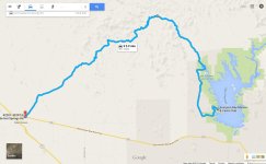
But for the meantime... I'm super stoked about taking castle hotsprings rd out to lake pleasant like I mentioned assuming no surprises. Seems like a super chill/fun/scenic drive while making lunch a destination :-D


as far as I know table mesa has been closed due to some nasty erosion, there is a 10 foot drop off right in the middle of the trail thatb is unpassable, unless you have a bulldozer to fill it in.
For reference this is actually what I was looking at.
So, I have a day available on August 15th and want to go hit a trail. Figured I would throw this out there for planning and recommendations! Whos in?
That is the CHS loop in the trail books I have - there is a spot somewhere towards the northern most part of the loop that continues west instead of heading south that can be taken all the way to the Hassayampa wash in Wickenburg