AssBurns
New member
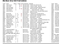
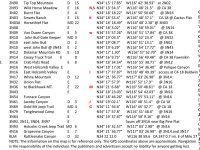
If anyone is interested, I got pretty much all of the San Bernardino Mountain's Trails and lots of waypoints in .gpx format. Basically all of Cleghorn, Big Bear and Bighorn Wilderness. Also a few random areas by the Salton Sea such as Truckhaven, Ocotillo Wells, and North Glamis Hot Springs. Also got some OC stuff in there too. I figured I'd share if anyone wants a link to the files in a Dropbox folder. Idk if the trail colors will carry over but they are colored for difficulty. The .zip file is to big to upload here, so let me know if you want the link and I'll PM it to you.
There are two ways I can send over the files. The first way is; I can send you a link to the Dropbox .zip folder that has all the individual tracks and waypoints as individual .GPX files.
The second way is the easier way in my opinion. I can send you an email with the single .GPX file that has everything (San Bernardino National Forest) in one. If you are using apps like Gaia or MotionX (Possibly others too), you can import the file directly to your device from the email. Just make sure you send me your email address in a PM. I will also send the link for the .zip file as well in the email if you'd like.
Let me know which way you want me to send it over to you in a PM.
If the colors carry over for you (I don't think they do),my color systems is the following:
Green = Easy
Blue = Moderate
Red = Difficult
Orange = OHV Trail (for dirt bikes, etc)
If there is any pink in there it's just a random track I've recorded. I tried to pull all those out though for you guys.
EDIT: I have and will continue to update the linked folder as I get more trails. I'm just going to rename the file in numerical order as I get more. If there are any trails that you have that are not in my files, please share so we can have a more complete file.
DISCLAIMER: A large majority of these tracks and waypoints were NOT recorded or created by me. The only thing I have done with these tracks and waypoints has been color coding, name tracks more effectively, clean up some junk waypoints to have less clutter. My sources for these tracks have been Friends, Trails Offroad, GPS Depot, GPS Owl, other forums and the few I've created myself. All I am doing is sharing my collection of tracks and waypoints for others to download easily.


There are two ways I can send over the files. The first way is; I can send you a link to the Dropbox .zip folder that has all the individual tracks and waypoints as individual .GPX files.
The second way is the easier way in my opinion. I can send you an email with the single .GPX file that has everything (San Bernardino National Forest) in one. If you are using apps like Gaia or MotionX (Possibly others too), you can import the file directly to your device from the email. Just make sure you send me your email address in a PM. I will also send the link for the .zip file as well in the email if you'd like.
Let me know which way you want me to send it over to you in a PM.
If the colors carry over for you (I don't think they do),my color systems is the following:
Green = Easy
Blue = Moderate
Red = Difficult
Orange = OHV Trail (for dirt bikes, etc)
If there is any pink in there it's just a random track I've recorded. I tried to pull all those out though for you guys.
EDIT: I have and will continue to update the linked folder as I get more trails. I'm just going to rename the file in numerical order as I get more. If there are any trails that you have that are not in my files, please share so we can have a more complete file.
DISCLAIMER: A large majority of these tracks and waypoints were NOT recorded or created by me. The only thing I have done with these tracks and waypoints has been color coding, name tracks more effectively, clean up some junk waypoints to have less clutter. My sources for these tracks have been Friends, Trails Offroad, GPS Depot, GPS Owl, other forums and the few I've created myself. All I am doing is sharing my collection of tracks and waypoints for others to download easily.
Last edited: