

TheSentinel
New member
DECEMBER MEET UP AND TRAIL RUN
The meet will be Saturday, 12 December. The run will be to Red Canyon trail in BLM lands East of Indio.
Difficulty: Fairly Easy.
The originally planned Anza Borrego run will be postponed until Al [MENTION=77357]85straight[/MENTION] can do the run that he had planned.
Organizer(s): TheSentinel (Jason)
Trail Leader(s): Oneluv13T4R (Miah)
Meet Location:
Love's Travel Stop
45-761 I-10 Exit 146, Dillon Rd, Coachella, CA 92236
<iframe src="https://www.google.com/maps/embed?pb=!1m26!1m12!1m3!1d212840.58058459996!2d-116.07781388635772!3d33.53689842676975!2m3!1f0!2f0!3f0!3m2!1i1024!2i768!4f13.1!4m11!3e6!4m5!1s0x80daf6488281c05b%3A0x73ccf65666bf1847!2sLove's+Travel+Stop%2C+45-761+I-10+Exit+146%2C+Dillon+Road%2C+Coachella%2C+CA+92236!3m2!1d33.7173635!2d-116.17128459999999!4m3!3m2!1d33.376736099999995!2d-115.6938813!5e0!3m2!1sen!2sus!4v1449632179362" width="600" height="450" frameborder="0" style="border:0" allowfullscreen></iframe>
From Los Angeles, go East on I-10 towards Indio until you hit the Dillion Road offramp.
*If anyone from San Diego is coming, you may meet us at the intersection of CA-111 and Hot Mineral Spa Road to save some time, we will be there at approx 10am.
Route: The route is clear.
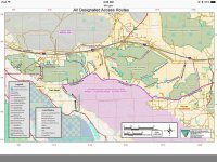
This is a gorgeous trail run, incredibly scenic. The route I discussed with Oneluv13T4R started through the Bombay Beach/Pope/Niland area, Hot Mineral Spa Road north until we meet up with the Bradshaw Trail. We will then proceed Northeast until we come upon Red Canyon Jeep Trail, proceeding Northwest until we come back out up by I-10. Though the run will not take all day, Chiraco Summit hosts a Dairy Queen and the Patton Museum, a great stop for kids to enjoy after a trail run.
Meeting time(s):
9:00AM at the Love's Travel Stop for Safety and Trail Meeting leaving for trail head immediately after. Please arrive prior to 9:00AM, I will be there early. Departure should be NLT 9:15AM.
We will be stopping for a scenic picnic on the trail, so bring snacks!
CB Channel/ FMRS Chanel:
13/13.1
Tentative Roster:
1. TheSentinel (Organizer)
2. Oneluv13T4R (Trail Leader)
3.
If I have missed anyone, please PM me and I'll add you to the list. I would like to verify our numbers before heading out. If you want off the roster, let me know in a PM.
What to bring with you:
Good Attitude - This group is big...we'll need to be patient with each other
Snacks, food, beverages (no alcohol consumption en route please)
$ for a meal afterwards (preferably cash in case they wont split check)
Spare fluids for vehicle
Recovery gear if you have it.
Recovery point front and rear (factory hook is fine)
Description:
Interstate 10 provides access to the wilderness from the north, State Highway 195 (Box Canyon Road) from the west and the Chiriaco Summit exit south along the Red Canyon four-wheel drive trail. The Bradshaw Trail provides access from the south.
50,960 acres. The western boundary of the Orocopia Mountains Wilderness is contiguous with the Mecca Hills Wilderness with the exception of the Meccacopia Jeep Trail, which bisects the two wilderness areas. The forces of nature have produced a striking landscape here where open valleys, ridges and highly colorful and dramatically eroded canyons are the result of the region's proximity to the San Andreas fault system. Deep canyons and washes cut across the entire area, exposing walls of color shaded from bright red to black. Bighorn sheep, burro deer, desert tortoise and many small upland game species live among the mountains. The spiny-leaved Orocopia sage, Alverson's foxtail cactus, Orcutt's woody aster and the Mecca aster grow unexpectedly in washes, on stony slopes and in gypsum soils.
Orocopia Mountains Wilderness Area | Bureau of Land Management California
Ranger Station Info:
Bureau of Land Management
Palm Springs - South Coast Field Office
1201 Bird Center Drive
Palm Springs, California 92262
Phone: (760) 833-7100
Note:
Don't forget to bring food and water!
...and no, we will not be going into the bombing range.
As always, I am open to all suggestions and comments.
Main Route:
The meet will be Saturday, 12 December. The run will be to Red Canyon trail in BLM lands East of Indio.
Difficulty: Fairly Easy.
The originally planned Anza Borrego run will be postponed until Al [MENTION=77357]85straight[/MENTION] can do the run that he had planned.
Organizer(s): TheSentinel (Jason)
Trail Leader(s): Oneluv13T4R (Miah)
Meet Location:
Love's Travel Stop
45-761 I-10 Exit 146, Dillon Rd, Coachella, CA 92236
<iframe src="https://www.google.com/maps/embed?pb=!1m26!1m12!1m3!1d212840.58058459996!2d-116.07781388635772!3d33.53689842676975!2m3!1f0!2f0!3f0!3m2!1i1024!2i768!4f13.1!4m11!3e6!4m5!1s0x80daf6488281c05b%3A0x73ccf65666bf1847!2sLove's+Travel+Stop%2C+45-761+I-10+Exit+146%2C+Dillon+Road%2C+Coachella%2C+CA+92236!3m2!1d33.7173635!2d-116.17128459999999!4m3!3m2!1d33.376736099999995!2d-115.6938813!5e0!3m2!1sen!2sus!4v1449632179362" width="600" height="450" frameborder="0" style="border:0" allowfullscreen></iframe>
From Los Angeles, go East on I-10 towards Indio until you hit the Dillion Road offramp.
*If anyone from San Diego is coming, you may meet us at the intersection of CA-111 and Hot Mineral Spa Road to save some time, we will be there at approx 10am.
Route: The route is clear.
This is a gorgeous trail run, incredibly scenic. The route I discussed with Oneluv13T4R started through the Bombay Beach/Pope/Niland area, Hot Mineral Spa Road north until we meet up with the Bradshaw Trail. We will then proceed Northeast until we come upon Red Canyon Jeep Trail, proceeding Northwest until we come back out up by I-10. Though the run will not take all day, Chiraco Summit hosts a Dairy Queen and the Patton Museum, a great stop for kids to enjoy after a trail run.
Meeting time(s):
9:00AM at the Love's Travel Stop for Safety and Trail Meeting leaving for trail head immediately after. Please arrive prior to 9:00AM, I will be there early. Departure should be NLT 9:15AM.
We will be stopping for a scenic picnic on the trail, so bring snacks!
CB Channel/ FMRS Chanel:
13/13.1
Tentative Roster:
1. TheSentinel (Organizer)
2. Oneluv13T4R (Trail Leader)
3.
If I have missed anyone, please PM me and I'll add you to the list. I would like to verify our numbers before heading out. If you want off the roster, let me know in a PM.
What to bring with you:
Good Attitude - This group is big...we'll need to be patient with each other
Snacks, food, beverages (no alcohol consumption en route please)
$ for a meal afterwards (preferably cash in case they wont split check)
Spare fluids for vehicle
Recovery gear if you have it.
Recovery point front and rear (factory hook is fine)
Description:
Interstate 10 provides access to the wilderness from the north, State Highway 195 (Box Canyon Road) from the west and the Chiriaco Summit exit south along the Red Canyon four-wheel drive trail. The Bradshaw Trail provides access from the south.
50,960 acres. The western boundary of the Orocopia Mountains Wilderness is contiguous with the Mecca Hills Wilderness with the exception of the Meccacopia Jeep Trail, which bisects the two wilderness areas. The forces of nature have produced a striking landscape here where open valleys, ridges and highly colorful and dramatically eroded canyons are the result of the region's proximity to the San Andreas fault system. Deep canyons and washes cut across the entire area, exposing walls of color shaded from bright red to black. Bighorn sheep, burro deer, desert tortoise and many small upland game species live among the mountains. The spiny-leaved Orocopia sage, Alverson's foxtail cactus, Orcutt's woody aster and the Mecca aster grow unexpectedly in washes, on stony slopes and in gypsum soils.
Orocopia Mountains Wilderness Area | Bureau of Land Management California
Ranger Station Info:
Bureau of Land Management
Palm Springs - South Coast Field Office
1201 Bird Center Drive
Palm Springs, California 92262
Phone: (760) 833-7100
Note:
Don't forget to bring food and water!
...and no, we will not be going into the bombing range.
As always, I am open to all suggestions and comments.
Main Route:
Attachments

Last edited:


 layball:


