Favorite 5th gen trails you've taken in Colorado/Rockies?

Just wanted to update the thread and ask another question -

So - we did the black hills, came up and over and are at our 4th day in Banff. Leaving Saturday for 4 nights in Jasper. It's been spectacular.

On the way back down I'm thinking we'll camp in Ouray and do some day trips.

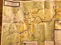
Question - of all the passes and such mentioned, does anyone have a link to a site/map to find the actual route? I use my iPhone as a gps with osmand maps to download gpx tracks if they're available. Just looking for a good resource.
 

Attachments

  • IMG_4258.jpg
    IMG_4258.jpg
    135 KB · Views: 381
  • Snapseed.jpg
    Snapseed.jpg
    137.4 KB · Views: 373
This is a pretty good map. You will have to zoom in on it to look at the specific area you want to travel. Once you get to the trail head, everything there after is well marked. There isn't much chance of getting lost or off the main path. The only trail that isn't marked that well is Corkscrew Gulch, but that's just at the beginning. Once you get on it, you are fine. If you have any questions just ask. I've been up there 3 times in the last 3 months.
 

Attachments

  • IMG_3363.jpg
    IMG_3363.jpg
    141.8 KB · Views: 363
If that map is too blurry, just stop in one of the jeep rental places in Ouray. There are 3-4 of them on the Main Street thru town. They will gladly give you a map and give you directions if you need them.
 
That is a good map and easy to find in Ouray.
Just remember Highway 550 is your friend, aka Million Dollar Highway. Engineer Pass begins off of it, Imogene does as well right above Ouray. Oh and so does Black Bear Pass...and CorkscrewGulch, Hurricane Pass, California...

Get my drift?! :smokin:
You'll find basing out of Ouray is going to put you in the middle of it all. Coming back from Telluride you can always take Ophir Pass back over, or take the pavement way to via highways. Have fun! These trails are famous for a reason...the scenery is incredible!
 
Thought I would offer a few tips on timing if you are going through Ouray. Fall colors usually peak between Ouray and Silverton around 15-20 Sep most years. If you hit that area later such as 27 Sep to 5 Oct, the highway west of Ridgway (which is 10 miles north of Ouray) has great color as you drive west parallel to the Sneffels Range.

This region is fantastic. It motivated me to buy my first 4Runner in 2004 which was also my first 4wheel drive vehicle. Just recently stepped into a Quicksand TRD Pro and loving it. All this due to the San Juan mountains!!
 
Thanks everyone for the input and all the additional direction.

While I'm a bit more than stock, I don't have a ton of Off Road experience and will be traveling with just my wife.

I.e. Which trails are harder vs easier? Pretend I'm stock - any trails you wouldn't recommend? I have a 3" lift, Toyo's, and sliders - but by myself I wouldn't like to cut anything too close.
 
Thanks everyone for the input and all the additional direction.

While I'm a bit more than stock, I don't have a ton of Off Road experience and will be traveling with just my wife.

I.e. Which trails are harder vs easier? Pretend I'm stock - any trails you wouldn't recommend? I have a 3" lift, Toyo's, and sliders - but by myself I wouldn't like to cut anything too close.

Honestly if its dry you'll be fine with everything around Ouray. You or your wife may need to spot the other coming down Black Bear...and Poughkeepsie has "the wall" that you might want to avoid. While the trails have varied a little with deepening ruts, the original FJ Summit in 2007 included all stock FJ Cruisers. They did all of these trails as stock FJC's.
You'll be fine.:yo:
 
The only one you should avoid solo is Poughkeepsie Gulch. It has a pretty tough obstacle. The Mineral Point road from 550 up to Engineer Pass is the next roughest road, but is easily doable in your vehicle. All of the roads are heavily traveled, so no worries about getting stranded alone for days. As said, the scenery is spectacular. Just drive around in your 4runner and enjoy it. It's ideally suited for it.

I've been all over that country- covered a lot of it years ago in a 2wd Ford pickup. I've always gone solo.
 
Plan your first stop in town at the Ouray visitor center for trail maps, info, etc; this will give you a good lay of the land, local sites, topography, and so on. Second, drop by Buckskin Booksellers near the south end of town by the Beaumont Hotel and pick up a copy of Colorado Trails: Southwest Region by Massey, Wilson, Titus (Adler Pub); it is both a great field guide to several dozen trails and real fun to look at in camp with lots of area history, photos, gps coordinates, etc. Colorado Backroads & 4wd Trails by Wells, Peterson (FunTreks Pub) is another good one and you can actually download the books waypoints online at https://www.funtreks.com/free-gps-waypoint-downloads , but I like the Massey book quite a bit more for a lot more detailed info for the SW CO region specifically.

For paid camping, the Amphitheater campground on the south end of Ouray is a good one, as is Ridgway State Park north of Ouray 15 miles or so, and there are some forest service campgrounds on the road to Yankee Boy Basin. You can rough it in plenty of areas not too far from town like Ironton Park area south of Ouray about 10 miles or so, Dallas Divide west of Ridgway 5-10 miles, or along CR 7 out of Silverton to name a few. I'd avoid the commercial in town campgrounds, KOAs, and the like–they cram you in really tight and they are always very crowded.

As others have said, definitely leave the trailer at camp. For trails (E, Easy; M, Moderate; D, Difficult, per the Wells book; #1-6 ratings per Massey book), Yankee Boy Basin (M, 3) is not to be missed. Recommend you take Imogene Pass (M, 4) over to Telluride for the stellar scenery and that time of year (sounds like you’ll be out here in another week or so?) the aspens should be fantastic coming back along Last Dollar Road (E). Alpine Loop is awesome–start at Mineral Creek (D) a few miles south of Ouray and do the loop clockwise over Engineer Pass (M, 4) to Lake City, then back over Cinnamon Pass (M, 3) to Animas Forks ghost town and into Silverton; get an early start and it will still be a VERY long day doing the whole loop in one shot with breaks for photo ops, history, etc; the first quarter of the loop to the top of Engineer Pass is the hardest of the trip and lots of fun, rocky and slow going, but the rest of the trail is pretty tame and they must have just graded Cinnamon Pass and the road from Silverton to Animas Forks–we were just there a week ago and those are as easy as I ever remember them. Clear Lake (E, 3) out of Silverton is a scenic trail to bring you up close to one of the many high alpine lakes in the area, or if you are up for a real challenging hike, neighboring Ice Lakes Basin is breathtaking. I would not recommend Black Bear Pass (D, 6) for a solo novice, although I have never personally done it on account of the notoriety–“Obstacles that may prove too challenging for inexperienced four-wheelers include tight, off-camber switchbacks, loose talus, and narrow shelf roads with thousand-foot-plus drop-offs” (... excerpt from Massey book); I’d say ask some of the locals and start with some of the other fantastic trails mentioned above and see how comfortable both you and your wife are to the exposure and terrain in the area and go from there.

Have fun–that is prettiest part of the state without a doubt and fall colors ought to be getting primo in the next week or so!

 
Last edited:
Plan your first stop in town at the Ouray visitor center for trail maps, info, etc; this will give you a good lay of the land, local sites, topography, and so on. Second, drop by Buckskin Booksellers near the south end of town by the Beaumont Hotel and pick up a copy of Colorado Trails: Southwest Region by Massey, Wilson, Titus (Adler Pub); it is both a great field guide to several dozen trails and real fun to look at in camp with lots of area history, photos, gps coordinates, etc. Colorado Backroads & 4wd Trails by Wells, Peterson (FunTreks Pub) is another good one and you can actually download the books waypoints online at Trails - FunTreks , but I like the Massey book quite a bit more for a lot more detailed info for the SW CO region specifically.

For paid camping, the Amphitheater campground on the south end of Ouray is a good one, as is Ridgway State Park north of Ouray 15 miles or so, and there are some forest service campgrounds on the road to Yankee Boy Basin. You can rough it in plenty of areas not too far from town like Ironton Park area south of Ouray about 10 miles or so, Dallas Divide west of Ridgway 5-10 miles, or along CR 7 out of Silverton to name a few. I'd avoid the commercial in town campgrounds, KOAs, and the like–they cram you in really tight and they are always very crowded.

As others have said, definitely leave the trailer at camp. For trails (E, Easy; M, Moderate; D, Difficult, per the Wells book; #1-6 ratings per Massey book), Yankee Boy Basin (M, 3) is not to be missed. Recommend you take Imogene Pass (M, 4) over to Telluride for the stellar scenery and that time of year (sounds like you’ll be out here in another week or so?) the aspens should be fantastic coming back along Last Dollar Road (E). Alpine Loop is awesome–start at Mineral Creek (D) a few miles south of Ouray and do the loop clockwise over Engineer Pass (M, 4) to Lake City, then back over Cinnamon Pass (M, 3) to Animas Forks ghost town and into Silverton; get an early start and it will still be a VERY long day doing the whole loop in one shot with breaks for photo ops, history, etc; the first quarter of the loop to the top of Engineer Pass is the hardest of the trip and lots of fun, rocky and slow going, but the rest of the trail is pretty tame and they must have just graded Cinnamon Pass and the road from Silverton to Animas Forks–we were just there a week ago and those are as easy as I ever remember them. Clear Lake (E, 3) out of Silverton is a scenic trail to bring you up close to one of the many high alpine lakes in the area, or if you are up for a real challenging hike, neighboring Ice Lakes Basin is breathtaking. I would not recommend Black Bear Pass (D, 6) for a solo novice, although I have never personally done it on account of the notoriety–“Obstacles that may prove too challenging for inexperienced four-wheelers include tight, off-camber switchbacks, loose talus, and narrow shelf roads with thousand-foot-plus drop-offs” (... excerpt from Massey book); I’d say ask some of the locals and start with some of the other fantastic trails mentioned above and see how comfortable both you and your wife are to the exposure and terrain in the area and go from there.

Have fun–that is prettiest part of the state without a doubt and fall colors ought to be getting primo in the next week or so!

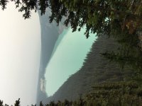
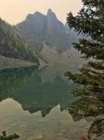
Man, you rock. Great info!


Sent from my iPad using Tapatalk
 
Last year we did Black Bear, Ophir, Imogene, and a good portion of the Alpine Loop. You really can't go wrong with any of them. Imogene is pretty long and somewhat challenging. Black Bear, just know what you're getting into. You probably don't want to take the trailer down Black Bear, the switch backs with a trailer could prove to be challenging. Alpine loop is all scenic and easy for the most part and was my favorite of the bunch.
 

Members online

Forum statistics

Threads
278,315
Messages
3,554,128
Members
248,016
Latest member
Advally Service

Trending content

Back
Top