Plan your first stop in town at the
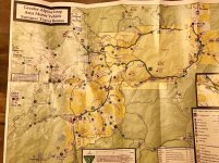
Ouray visitor center for trail maps, info, etc; this will give you a good lay of the land, local sites, topography, and so on. Second, drop by
Buckskin Booksellers near the south end of town by the Beaumont Hotel and pick up a copy of
Colorado Trails: Southwest Region by Massey, Wilson, Titus (Adler Pub); it is both a great field guide to several dozen trails and real fun to look at in camp with lots of area history, photos, gps coordinates, etc.
Colorado Backroads & 4wd Trails by Wells, Peterson (FunTreks Pub) is another good one and you can actually download the books waypoints online at
Trails - FunTreks , but I like the Massey book quite a bit more for a lot more detailed info for the SW CO region specifically.
For paid camping, the
Amphitheater campground on the south end of Ouray is a good one, as is
Ridgway State Park north of Ouray 15 miles or so, and there are some forest service campgrounds on the road to Yankee Boy Basin. You can rough it in plenty of areas not too far from town like
Ironton Park area south of Ouray about 10 miles or so,
Dallas Divide west of Ridgway 5-10 miles, or along
CR 7 out of Silverton to name a few. I'd avoid the commercial in town campgrounds, KOAs, and the like–they cram you in really tight and they are always very crowded.
As others have said, definitely leave the trailer at camp. For trails (E, Easy; M, Moderate; D, Difficult, per the Wells book; #1-6 ratings per Massey book),
Yankee Boy Basin (M, 3) is not to be missed. Recommend you take
Imogene Pass (M, 4) over to Telluride for the stellar scenery and that time of year (sounds like you’ll be out here in another week or so?) the aspens should be fantastic coming back along
Last Dollar Road (E).
Alpine Loop is awesome–start at
Mineral Creek (D) a few miles south of Ouray and do the loop clockwise over
Engineer Pass (M, 4) to Lake City, then back over
Cinnamon Pass (M, 3) to
Animas Forks ghost town and into Silverton; get an early start and it will still be a VERY long day doing the whole loop in one shot with breaks for photo ops, history, etc; the first quarter of the loop to the top of Engineer Pass is the hardest of the trip and lots of fun, rocky and slow going, but the rest of the trail is pretty tame and they must have just graded Cinnamon Pass and the road from Silverton to Animas Forks–we were just there a week ago and those are as easy as I ever remember them.
Clear Lake (E, 3) out of Silverton is a scenic trail to bring you up close to one of the many high alpine lakes in the area, or if you are up for a real challenging hike, neighboring
Ice Lakes Basin is breathtaking. I would not recommend
Black Bear Pass (D, 6) for a solo novice, although I have never personally done it on account of the notoriety–“Obstacles that may prove too challenging for inexperienced four-wheelers include tight, off-camber switchbacks, loose talus, and narrow shelf roads with thousand-foot-plus drop-offs” (... excerpt from Massey book); I’d say ask some of the locals and start with some of the other fantastic trails mentioned above and see how comfortable both you and your wife are to the exposure and terrain in the area and go from there.
Have fun–that is prettiest part of the state without a doubt and fall colors ought to be getting primo in the next week or so!