Help me prep for my trip to Colorado!

I'm surprised nobody mentioned black bear pass. I have not been in the Ouray area yet, but it is on my must do list. It seems to have absolutely epic views.

It might be a bit difficult this year (not sure). I've heard it will really get most peoples heart racing, although it is not actually that difficult. Just a section of narrow switchbacks where failure is not an option.

You didn't read the part of his first post that said "I don't plan on doing any extreme wheeling but would give the truck a good workout and be completely safe at the same time."

That is exactly why those that know, did not mention it.

Recommending trails for a first timer to that area that you have not driven yourself is pretty irresponsible. Black bear is the last trail I'd recommend for the requirements that Alex listed, level of CO trails experience, etc.

That trail could totally unnerve his passengers and ruin his trip.

Sorry if I'm going off on you but I love this area and want people to enjoy it enough so they have HAVE to go back. The last thing you want is for his GF to hate it so she'll never go back.

I guarantee you, if they look up at it from Telluride, his passengers would shoot him for wanting to try it.
 
I'm surprised nobody mentioned black bear pass. I have not been in the Ouray area yet, but it is on my must do list. It seems to have absolutely epic views.

It might be a bit difficult this year (not sure). I've heard it will really get most peoples heart racing, although it is not actually that difficult. Just a section of narrow switchbacks where failure is not an option.

Don't think it's appropriate for OP, traveling with a car full of people that don't offroad, too dangerous and they will never go again.

You didn't read the part of his first post that said "I don't plan on doing any extreme wheeling but would give the truck a good workout and be completely safe at the same time."

That is exactly why those that know, did not mention it.

Recommending trails for a first timer to that area that you have not driven yourself is pretty irresponsible. Black bear is the last trail I'd recommend for the requirements that Alex listed, level of CO trails experience, etc.

That trail could totally unnerve his passengers and ruin his trip.

Sorry if I'm going off on you but I love this area and want people to enjoy it enough so they have HAVE to go back. The last thing you want is for his GF to hate it so she'll never go back.

I guarantee you, if they look up at it from Telluride, his passengers would shoot him for wanting to try it.

I was looking at Black Bear on some other threads and I think the others are correct. After seeing the video of the Jeep roll off the edge from what looked like a minor mistake I think it's best to leave that one out.

Maybe next time after I get more experience under my belt and more comfortable with the 4Runner. I'm sure there will be plenty of other amazing views to be had on other trails.


Thanks everyone! So far this thread has been extremely helpful for planning.
 
+1 on what was said here! Alpine Loop will give y'all a lot more scenery to enjoy and won't beat folks up as much!!


You're already set up pretty good for the trip. Being able to air down to about 25 psi (with 4 people) at the trail beginning will make the ride and traction better for you and your passengers. It will be new for them as well and their happiness can make or break your trip. (grin)

Imogene is fun, but it's very rocky and requires picking a good line and going slow. The rocks can be scary looking to first time riders. If your heart is set on Imogene, and you can start at 7am, drive into Ouray, take your time going up Imogene and eat lunch in Telluride. Come back on Imogene and do Yankee Boy, eat dinner in Ouray, or come back over Ophir pass and stop in Silverton headed back. I much prefer Ouray to Silverton and there more stuff and better $ places to eat for your riders.

If your heart is not set on Imogene and since you're coming from the south, take the trail through Silverton to Animas Forks up to Engineer pass to Lake City and then back past American Basin (wild flower heaven) and Cinnamon Pass back to Animas Forks. It's much easier than Imogene but takes all day. It's just as pretty for the passengers but not as technical. This is called the Alpine Loop. Depending on your time there are great side trails coming back to Silverton.

In the Ouray area in summer, you get dirty in the morning and sort of cleaned off by the thunder storms in the afternoon. It's guaranteed. There are lots of people on these trails in summer to help if you get into trouble. Air back up at the end of the trail before hitting 550.

The train ride is an all day thing. You see the valleys. Off road the next day to see the tops.

You have time to order the Charles Wells book. Do yourself a favor and get it. Read it before you go. You WILL be going back, I promise. 20+ years of consecutive trips taking here.

4x4 and SUV Books : Guide to Colorado Backroads & 4WD Trails (3rd Edition) Cover Price: $34.95

I have all three editions for CO, AZ, and UT. (grin) It will tell you what a driver needs to know.

I could write a book about what to do, but you will leave wishing you had more time to do more trails.

When you get there, keep in mind I did all but two of the trails in my new stock non-lifted 2014 TEP with just BFG's. http://www.toyota-4runner.org/off-roading/172567-ouray-co-late-june-2014-a.html

No problem. Go slow, look at the scenery, have fun. You'll be fine.

Remember, the rear end on this 5th gen sticks out a bit so just because your rear tires are done, the arse end isn't done yet as it drops down.

PS, all of these trails are on Garmin and your Toyota nav which also uses the same Navtec DB.

 
A buddy of mine, well versed in 4-wheeling did Black Bear Pass 2 weeks ago; said the road was washed out in a couple of spots that really induced pucker factor (even for him). Near the top, there was a major mud-pit to cross and he had to backup 3 times and finally gun it in order to get past! Would not recommend Black Bear Pass...


You didn't read the part of his first post that said "I don't plan on doing any extreme wheeling but would give the truck a good workout and be completely safe at the same time."

That is exactly why those that know, did not mention it.

Recommending trails for a first timer to that area that you have not driven yourself is pretty irresponsible. Black bear is the last trail I'd recommend for the requirements that Alex listed, level of CO trails experience, etc.

That trail could totally unnerve his passengers and ruin his trip.

Sorry if I'm going off on you but I love this area and want people to enjoy it enough so they have HAVE to go back. The last thing you want is for his GF to hate it so she'll never go back.

I guarantee you, if they look up at it from Telluride, his passengers would shoot him for wanting to try it.
 
When wheeling that far from home the biggest preparation you can have is your bank account. I just blew my rear ring and pinion at the FJ Summit and because of the areas solitude it extrapolated my costs several thousand dollars. :boom:
 
Silverton is all about ridiculously easy fourwheeling, Subarus stalling out from lack of gearing and smoking clutches is common on all trails. Always shift into Low BEFORE you think you need it to keep your engine cool. Only one trail is hard, Poughkipsee. Its more about scenery and history. If this is a once in a lifetime trip go ahead and do Black Bear Pass. Many trails are done as a loop, such as Black Bear to Ouray and back over Imogene. Stoney pass is pretty interesting as well. Cinnamon and Engineers are crowded and boring. Other things to do;

1. Old 100 Mine tour
2. Mayflower Mill Tour
3. Check out the steam engines when they roll into town
4. Visit a fully restored mill in California Gulch
5. Hot Springs in Ouray
6. Get off-road in the Red Mtn district and check out all the historical stuff
 
So glad I found this. I am taking almost the exact same trip. Leaving on August 9th.

I will have my wife, two 65lb dogs and a pop-up camper with me. It is my first time using a pop-up and will be the longest road trip we've taken with the dogs. So we will most likely be taking things slow. I also don't think my wife is too keen on us going on anything but the easiest trails. We will mainly just be looking for good views and places to camp.

So far we are planning on going to the dunes, Pagosa Springs, Durango and Ouray. Maybe we will run into you out there.
 
From another source I have, this just in (21 July 2015: 11:47am MT):

"Porphyry Basin - road is closed about a mile before the waterfall for construction, will be closed for about another 6 weeks."
 
You didn't read the part of his first post that said "I don't plan on doing any extreme wheeling but would give the truck a good workout and be completely safe at the same time."

That is exactly why those that know, did not mention it.

Recommending trails for a first timer to that area that you have not driven yourself is pretty irresponsible. Black bear is the last trail I'd recommend for the requirements that Alex listed, level of CO trails experience, etc.

That trail could totally unnerve his passengers and ruin his trip.

Sorry if I'm going off on you but I love this area and want people to enjoy it enough so they have HAVE to go back. The last thing you want is for his GF to hate it so she'll never go back.

I guarantee you, if they look up at it from Telluride, his passengers would shoot him for wanting to try it.


RELAX! I don't think it is irresponsible. I just mentioned it. It's suppose to be easy (but intimidating), but I realize the conditions change from year to year depending on when you try it and everyone's tolerance for challenges are very different.
 
If you don't want to do the switchbacks, you can drive to the start of the 1 way section on Black Bear and turn around. It is very scenic.

I do that a lot to not have to deal with Telluride and Imogene traffic.
 
Eat at Durango Doughworks

Drive up to Ouray via Highway 550. It's a beautiful drive that your passengers will love.
This was shot heading south on 550 from Ouray to silverton.
IMG_9222.jpg by rlphoto1, on Flickr

On Highway 550 check out some Ghost Towns

I highly suggest Imogene Pass from Ouray to Telluride. Give yourself a good 3 hours to complete the trail. Stop at the summit and have lunch.

Another great trail that's easy is Last Dollar Rd. This will take you straight to Telluride. coordinates 38.099923, -107.912464.
IMG_1134.jpg by rlphoto1, on Flickr

Looking at your build thread I'd say you're good to go with your 4runner. Be sure to air down to 20-25psi. Will make the ride much more comfortable. What will you be using for gps?

Safe travels and be sure to take LOTS of pictures and post them back here.
 
Last edited:
We usually do Breckinridge or Keystone. Both great areas with several decent trails and great views. We also always have one meail at Dillon Dam Brewery. Take pictures and keep us updated on your travels!

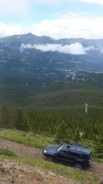
This picture is us on a trail and in the distance you can actually see the ski runs for Breck from last year.
This year due to the duration of our trip we did a roof top tent, air compressor, hi lift, fuel can etc. I would say at least one full size spare as you already have is a good start.

Have fun!
 

Attachments

  • brekenridge.jpg
    brekenridge.jpg
    137.6 KB · Views: 486
  • ruts.jpg
    ruts.jpg
    141 KB · Views: 460
  • panoramic.jpeg
    panoramic.jpeg
    35 KB · Views: 459
Last edited:
Eat at Durango Doughworks

................
Looking at your build thread I'd say you're good to go with your 4runner. Be sure to air down to 20-25psi. Will make the ride much more comfortable. What will you be using for gps?

Safe travels and be sure to take LOTS of pictures and post them back here.

Thanks for the info! As far as GPS, it's crossed my mind but I'm nut sure what I would need for it. One person mentioned most of the trails are on the 4Runner navi system. How does cell phone GPS work up in the mountains? I figure service will be minimal but if I download offline versions of maps to my cell phone or tablet would that work well enough?
 
Thanks for the info! As far as GPS, it's crossed my mind but I'm nut sure what I would need for it. One person mentioned most of the trails are on the 4Runner navi system. How does cell phone GPS work up in the mountains? I figure service will be minimal but if I download offline versions of maps to my cell phone or tablet would that work well enough?

Someone recommended an app to me for trail maps that was supposedly THE app to have. I think it's called Gaia. Supposedly it works on and offline or maybe it was two separate apps. I want to say it ran about $20. Can anyone confirm?
 
Thanks for the info! As far as GPS, it's crossed my mind but I'm nut sure what I would need for it. One person mentioned most of the trails are on the 4Runner navi system. How does cell phone GPS work up in the mountains? I figure service will be minimal but if I download offline versions of maps to my cell phone or tablet would that work well enough?

Someone recommended an app to me for trail maps that was supposedly THE app to have. I think it's called Gaia. Supposedly it works on and offline or maybe it was two separate apps. I want to say it ran about $20. Can anyone confirm?

I use Gaia app on my phone and iPad and it works great. I was using the bad elf GPS dongle and it worked fine but I'm looking into this one that's receive very good reviews.

http://www.amazon.com/Dual-Electronics-XGPS150-Discontinued-Manufacturer/dp/B004M3BICU

As for trail maps I go here TrailDamage.com - Imogene Pass and download the trail then upload to Gaia app.
 
We will be staying just about half way between Durango and Silverton CO and from what I gather this is quite the off road paradise with Imogene and several other big trails in the area.

If you happen to be in "can't get enough info" mode, here's a decade old trip report covering much of that area. There's some discussion of various trails within the thread. The trails listed in the first post that are from that are:

Yankee Boy Basin
Imogene Pass
Black Bear Pass
Alpine Loop
Corkscrew-California Gulch-return Engineer Pass
County Road 5-Ridgway
Owl Creek Pass

http://www.toyota-4runner.org/gallery/13977-november-2005-t4rotm-jb.html
 
Keep in mind camping is difficult, due to everything so high and steep. And the Silverton Valley is crowded. We like Black Bear, drive up from the Silverton side from the pass to just before it gets steep and go left across the stream, lots of great camping and not far to get to each day. Should not be too hard with a pop up with reasonable clearance.
 
Keep in mind camping is difficult, due to everything so high and steep. And the Silverton Valley is crowded. We like Black Bear, drive up from the Silverton side from the pass to just before it gets steep and go left across the stream, lots of great camping and not far to get to each day. Should not be too hard with a pop up with reasonable clearance.

Thankfully we won't have to worry about camping. Since I convinced the parents they could use a vacation and to tag along they booked a nice cabin on Columbine lake just a mile south of Durango Mountain Resort.

When I was a kid going with my parents we used to camp in Estes Park all the time. Now that my pops is older and has a bad back he doesn't mind paying for the finer things like a soft bed and running water :biggrin1:

If it was just the GF and I we probably would have been posting up at a campsite somewhere. Although I would enjoy taking a nice camping trip sometime in the future.


Here is the place the pops booked for the week. Going to be pretty nice!
Rocky Mountain luxury - including a private... - VRBO
 
Thanks for the info! As far as GPS, it's crossed my mind but I'm nut sure what I would need for it. One person mentioned most of the trails are on the 4Runner navi system. How does cell phone GPS work up in the mountains? I figure service will be minimal but if I download offline versions of maps to my cell phone or tablet would that work well enough?

You can get your coordinates from your trucks navigation, it's under "emergency" not sure if it is elsewhere. I've never had my navs map up while off-road as I either knew the route or had Welles book and my wife navigating which always works well. Cell coverage is bad here in the mountains, sometimes it's good but mostly not. I have a Spot locator and if you don't have a CB, might be handy even a handheld with a mag antenna.

I'm old school with maps, have a ton of those tear proof ones, personally I like that over relying on electronics.

Just more stuff to think about, haha
 

Members online

Forum statistics

Threads
278,316
Messages
3,554,120
Members
248,016
Latest member
Advally Service

Trending content

Back
Top