
JohnTheLuck's Adventures Thread

Day 53:

Start point: Page AZ
End point: Page AZ

Distance driven: 204 km
Distance hiked: 4.6 km

When we got out of bed, the rain had stopped and a few breaks in the clouds were visible. We were confident that we would have a great day. When we left the hotel, we decided to go for a hike in The Cockscomb Wilderness Study Area where we were a few days ago. This time, we wanted to go along the wash which runs along the inclined plane. Driving west and gaining altitude, we saw thick clouds towards our destination. So we abandoned and turned around.

We tried our luck on Smoky Mountains Road in Glen Canyon National Recreation Area. The first six kilometers are maintained and made of gravel. It was in fairly good condition. We then encountered a Jeep Wrangler covered in mud. The driver told us that the road was really slippery further and he even turned around. We still continued to reach the end of the maintained section. This road is very photogenic even under the clouds.

49657486317_d3dc5869e5_o.jpg


49657549467_c66bb489d5_o.jpg


Then we returned to the Carl Hayden Visitor Center near the Glen Canyon Dam and the bridge over the Colorado River.

49657550237_238a5dd35e_o.jpg


49656733763_95081e7a0e_o.jpg


After a good meal, we tried our luck once again for The Cockscomb Wilderness Study Area. Again, the threatening clouds appeared as we reached the entrance. We have once again given up. Instead, we headed to Catstair Canyon located nearby. A short hike leads to a usually dry fall.
49657285496_19140d9d1d_o.jpg


49656741738_d6acc7438b_o.jpg


On our way back to Page, we stopped at the Big Water Visitor Center. There, we saw a great exhibit about dinosaurs, mostly excavated from the Kaiparowitz Plateau in Grand Staircase-Escalante National Monument.

49657564632_1dec9d2c04_o.jpg


We then returned to Page resolved to enjoy some sun. When we arrived, it was once again masked by clouds. Certainly, we were not due to see the sun of the day. We still went for a walk on the hills of The Chains, bordering Lake Powell in Glen Canyon National Recreation Area.

49657564062_ceab0402d4_o.jpg


49656750838_46c4ba72ee_o.jpg


49657566542_7324755e7d_o.jpg


As the precipitation has stopped for a few days, we hope that the roads are dry enough to reach our destinations and do our activities.
.
 
Last edited:
Wow, what a grand adventure. I love that area of AZ and UT. The Southwest is getting some rainy weather lately. What’s next on your itinerary?
 
Wow, what a grand adventure. I love that area of AZ and UT. The Southwest is getting some rainy weather lately. What’s next on your itinerary?

Thanks! This is indeed an incredible area to explore, but in dryer conditions. Today was our sixth day near Page and, except for the first one on the Paria Plateau, we had droplets, showers, or rain. Today, we got back onto Smoky Mountains Road and Cottonwood Canyon Road and they just begin to be passable but there are still many mud patches. With all those dark clouds in succession, I didn't want to take some risks. This is why we do mostly hiking and not trails with the 4Runner
 
Day 54:

Start point: Page AZ
End point: Page AZ

Distance driven: 119 km
Distance hiked: 14.1 km

Even today, the weather was gloomy, with a few clearings this morning and less as the day progressed. In the last six days we have spent in Page, only one has been without precipitation. In the others, we received either a few droplets, or showers or rain. This is very abnormal for the region.

As this precipitation makes the majority of roads impassable, our choice of activities is greatly affected. It is for this reason that we do so many hikes and very few off-road trails with the 4Runner.

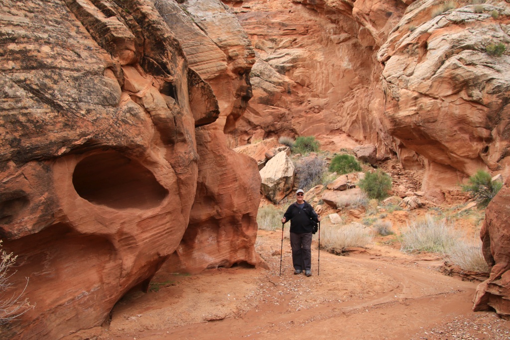
We spent the whole day exploring Wiregrass Canyon in Glen Canyon National Recreation Area. We learned about it yesterday as we were travelling part of the Smoky Mountains Road. As the parking lot is on the maintained part of the road, we were able to get there without difficulty.

Wiregrass Canyon begins as deep drainage but quickly becomes quite spectacular.

49663907993_1362831050_o.jpg


After a little less than two kilometers, we encountered the only notable obstacle: a dry fall. A hiker we had met before indicated the way around. It rises to the level of the plateau before descending quite abruptly on the other side.

49664446091_3e311c0a2b_o.jpg


49664731707_a72ce51135_o.jpg


Back at the bottom of the canyon, we returned to the dry fall that we had just avoided. This portion of the canyon is much narrower.

49664445656_218f6a71eb_o.jpg


49663908433_238021138f_o.jpg


49664445991_8975745911_o.jpg


Continuing in the canyon, we reached an arch dug by the water coming from a secondary wash.

49664445686_f33bf36b41_o.jpg


49663908323_6d1aef8370_o.jpg


Then, a little further, we circulated under a huge alcove dug by the water in a tight bend in the canyon. The photo does not do justice to the size because the overhanging part was at least ten meters advanced over the wash.

49664731572_a842b9eba8_o.jpg


In several places, the eddies and the wind have hollowed out the cliff of a multitude of small cavities.

49664445831_723078d9bb_o.jpg


49664445911_f3c2134eef_o.jpg


49663908168_ab16f5351c_o.jpg


After several hesitations on our return point and consultation of the topographic maps on our GPS, we decided to continue to a place that we think is suitable for another arch. We were right!

49664445761_abde53b86f_o.jpg


At this point, our GPS did not agree on the distance we had travelled from the starting point. This varied between 6 and 10 kilometers. We estimated that it would take at least two more kilometers to reach the place where we could see the waters of Lake Powell. With the threatening clouds approaching, we therefore wisely decided to turn around.

We were nevertheless fortunate to have some beautiful breaks in the clouds when we returned.

49664731392_be01556663_o.jpg


49664731357_7ec3975f31_o.jpg


Tomorrow, we hope to be able to go to the last long hike that my wife had designed during our preparation, obviously assuming that Cottonwood Road is passable, which is not guaranteed.
.
 
Last edited:
Day 55:

Start point: Page AZ
End point: Amarillo TX
States travelled: AZ, NM, TX

Distance driven: 1064 km

Following the recommendations of the Government of Canada regarding travellers to the United States and the coronavirus, we decided to end our trip. Sadly. So we left Page this morning. We are now in Amarillo, Texas.
.
 
Last edited:
Day 56:

Start point: Amarillo TX
End point: St. Louis MO
States travelled: TX, OK, MO

Distance driven: 1204 km

We got back on the road quite early this morning, under an overcast sky and some light showers. We arrived in St. Louis, Missouri for supper, but the coronavirus crisis is starting to cause effects such as the closing of dining rooms in restaurants. So we ate our supper in the 4Runner!
.
 
Last edited:
Day 57:

Start point: St. Louis MO
End point: Erie PA
States travelled: MO, IN, OH, PA

Distance driven: 1095 km

Another cloudy day on the road, but at least we had no precipitation.

We made a short stop near Indianapolis to meet some friends. Farther near Columbus, we had some slowdowns caused by oversized load convoys, and an incredible number of trucks.

We are in Erie, Pennsylvania. Tomorrow we will finally be back home.
.
 
Last edited:
Following the recommendations of the Government of Canada regarding travellers to the United States and the coronavirus, we decided to end our trip. Sadly. So we left Page this morning. We are now in Amarillo, Texas.
.

Bummer. Probably a smart move, but still disappointing for sure.
 
Day 58:

Start point: Erie PA
End point: Monrtreal QC
States travelled: PA, NY, ON, QC

Distance driven: 750 km

We finally came back home, obviously quite disappointed to have shortened our stay a bit, but still very satisfied with what we saw and did. Obviously, in the current circumstances, we do not know when we can leave for another destination.

In the next few days, I will write a summary of this great trip in Arizona.

Meanwhile, I wish to thank all of you who help me put this trip together, with a special thank to [MENTION=306890]MAST4R[/MENTION] for joining us on the trails. It was a great trip. Thanks also to all of you who followed us during this journey. We had a great time out there.
.
 
Last edited:
John I just want to say thanks for sharing. I live pretty close to Yuma and you've added a lot of destinations to my list of things to see. I'm glad you got home while travel was easy. Thanks again and stay healthy.
 
John I just want to say thanks for sharing. I live pretty close to Yuma and you've added a lot of destinations to my list of things to see. I'm glad you got home while travel was easy. Thanks again and stay healthy.

Thanks!

You should look back a few pages in this thread since we spend a lot of time last years in Southern California. There again was an absolute blast!
 
Awesome pics! Too bad about the premature end of the trip, but at least you got to cover a huge amount of territory in the time you had.
 
Awesome pics! Too bad about the premature end of the trip, but at least you got to cover a huge amount of territory in the time you had.

Really enjoyed reading your trip report. Thank you for sharing the amazing views.

Thanks a lot!

It was a really great trip even if it was shortened a bit. We still had time to do most of the things we planned to do. It is not like my first ever trip with the 4Runner back in spring 2016 when only a few days after finally reaching Moab our first destination my father died and we had to go back immediately. That one was really bad timing.

Anyway, we should be back in the Southwest in a near future, hopefully...
.
 
:nicethread:

Thank you for your posts and pictures. You did a terrific job capturing your trip through Arizona, and other parts of the southwest. Just discovered this thread today, and have spent a lot of time enjoying it. And I'll continue to work my way backwards through your earlier posts.

We live in Prescott, and have explored many of the same areas -- but you've also gotten to many places we still need to explore. Quite the mix of 'I remember that spot', and 'we need to go see that spot...'. Adding several stops to our travel list now :).

We also went up to the Painted Desert & Petrified Forest about a week after you were through there. We came back in a loop back by Roosevelt Lake and Peyson. Glad we were able to do that just before the travel restrictions started to be recommended.

We only posted a few pictures of our trip up to that area in the 'what did you do today thread.' I really should post some more in the 4Runner picture thread. Or maybe start following your lead by capturing images with an 'adventures thread' approach. Even if some of the 'adventures' are just in our back yard :).

If you pass through this way again, please let us know.
 
Thanks for your kind words.

Many years ago, I decided to write a message on a blog I created to allow my parents to be able easily to follow me and my wife during these long duration trips. I found out I am using this blog myself a lot when I want to show someone a place we went. While this blog is in french (I am from the province of Quebec in Canada), a quick Google Translate and required corrections allows me to also write my Adventures Thread on T4R without too much effort. The total process is a bit time consuming but after a full day on a hiking trail or off-roading, the evening would bet spent resting anyway.

There is a high probability that we go back near Prescott in the future. But for now with this COVID-19, I can't see when we will leave for another trip in the 4Runner. The situation at my hometown is still not so great and I am watching the situation in the US as well. I am not so optimistic.

When we will go back, I will try to meet you, I as did with [MENTION=306890]MAST4R[/MENTION] this year. We had a lot of fun together. Since then, stay safe.
.
 
2020-01 New Mexico and Arizona Recap

After a few weeks back home from his great trip in southern New Mexico, Arizona and southern Utah, it is now time for a short recap.


Highlights:

- This trip is the first in the 4Runner since my wife decided to retire also, so we didn't have a hard return date;
- A lot of awesome off-road trails;
- A lot of great hiking trails;
- Some wildflowers but we might be a bit early in the season;
- Saguaro and Organ Pipe Cactus are so cool!;
- Unusual rainfall around Page impacted a lot of activities we had planned to do;
- Interruption caused COVID-19 and recommendation from the Canadian government to come back in Canada ASAP;


Statistics:

Trip duration: 58 days
States visited: Southern New Mexico, Arizona, Southern Utah
Pictures taken (with 3 shots exposure bracketing): 22787 / 101 GB

Distance driven (real): 20628 km / 12818 miles

Fuel used: 2950 liters / 779 US gallons
Consumption (displayed): 14.8 l/100 km / 15.9 mi/US gal
Consumption (real): 14.3 l/100 km / 16.4 mi/US gal


New Mexico Off-road trails driven:
- Organ Mountains-Desert Peaks NM, Desert Peaks Area: Kilbourne Road
- Prehistoric Trackway NM: Skyline Road
- Prehistoric Trackway NM: Apache Dam Road

Arizona Off-Road trails driven:
- Bisbee Area: Mule Mountains Road
- Coronado NF, Santa Catalina RD: Redington Road
- Coronado NF, Douglas RD: Pine Canyon Road (partial due to permanent closure)
- Coronado NF, Douglas RD: Pinery Canyon Road
- Coronado NF, Douglas RD: Tex Canyon Road
- Coronado NF, Douglas RD: Carr Canyon Road (partial due to seasonal closure)
- Coronado NF, Sierra Vista RD: Mexican Border Road
- Coronado NF, Nogales RD: Ruby Road (FR 39)
- Wilcox Area: Jackson Cabin Road
- Mammoth Area: Copper Creek Mining District Road
- Robbins Butte Wildlife Area: Robbins Butte WA Road
- Salome Area: Saddle Mountain Road (full loop around mountain)
- Kofa NWR: Engesser Pass Road (with [MENTION=306890]MAST4R[/MENTION])
- Kofa NWR: Yaqui Tanks Road (with [MENTION=306890]MAST4R[/MENTION])
- Kofa NWR: King Valley Road (with [MENTION=306890]MAST4R[/MENTION])
- Quartzsite Area: New Water Mountains Road
- Quartzsite Area: South Plomosa Range Road
- Organ Pipe Cactus NM: Puerto Blanco Drive
- Organ Pipe Cactus NM: Ajo Mountain Drive
- Wickenburg Area: Box Canyon of the Hassayampa Road
- Florence Area: Price Road
- Florence Area: Box Canyon Road
- Florence Area: Sandman Road
- Superior Area: Historic Pinal Cemetery Road
- Superior Area: Walnut Canyon Road (with [MENTION=306890]MAST4R[/MENTION])
- Superior Area: Mineral Mountain Road
- Superior Area: Cottonwood Canyon Petroglyphs Road
- Superior Area: Reymert Mine Road
- Agua Fria NM and Tonto NF, Cave Creek RD: Bloody Basin Road
- Prescott NF: Jerome-Perkinsville Road (FR318)
- Tonto NF, Globe RD: Montana Mountain Road
- Tonto NF, Mesa RD: Willow Springs Road
- Tonto NF, Mesa RD: Bulldog Canyon Road
- Tonto NF, Mesa RD: Mount Ord Road
- Tonto NF, Cave Creek RD: New River (Table Mesa) Road
- Tonto NF, Cave Creek RD: Camp Creek Road
- Tonto NF, Mesa RD: Mount Ord Road
- Tonto NF, Mesa RD: Pine Mountain Road (FR 201)
- Tonto NF, Mesa RD: Saddle Mountain Road (FR 25)
- Tonto NF, Mesa RD: Four Peaks (El Oso) Road
- Tonto NF, Tonto Basin RD: Edwards Park Road (FR 422)
- Tonto NF, Tonto Basin RD: A-Cross Road (FR 60)
- Tonto NF, Mesa RD: Roosevelt Vista Road (FR 140)
- Tonto NF, Mesa RD: Parker Point Road (FR 488)
- Coconino NF, Flagstaff RD: O'Leary Basin Road
- Flagstaff Area: SP Crater Road
- Cameron Area: Gray Mountain Road
- Glen Canyon NRA: Stud Horse Point Road
- Glen Canyon NRA: Smoky Mountain Road
- Grand Staircase-Escalante NM: House Rock Valley Road
- Vermililon Cliffs NM: Sand Hills Road

Utah Off-Road trails driven:
- Grand Staircase-Escalante NM: Cockscomb Wilderness Road
- Grand Staircase-Escalante NM: Cottonwood Canyon Road (BLM 400)
- Grand Staircase-Escalante NM: Paria Canyon Road
- Grand Staircase-Escalante NM: Paria Breaks Road
- Parunuweap Canyon WSA: Twin Hollow Road


New Mexico Scenic Roads:
- White Sands NM: Dune Drive

Arizona Scenic Roads:
- Saguaro NP, Rincon Mountain District (E): Cactus Forest Drive
- Coronado NF, Santa Catalina RD: Catalina Highway Scenic Drive
- Chiricahua NM: Bonita Canyon Scenic Drive
- Organ Pipe Cactus Scenic Road (AZ 85)
- Gila-Pinal Scenic Road (US 60)
- Copper Corridor Scenic Road (AZ 77, AZ 177)
- Prescott NF: White Spar Road (AZ 89)
- Prescott NF: Mingus Mountain Scenic Road (US 89A)
- Jerome, Clarkdale, Cottonwood Historic Road
- From the Desert to Tall Pines Scenic Byway (AZ 288, FR 512)
- Fredonia-Vermillion Cliffs Scenic Byway (US 89A)
- Naat'tsis'aan-Navajo Mountain Scenic Road (AZ 88)

Utah Scenic Roads:
- Glen Canyon NRA: Lakeshore Drive


Texas Parks/Monuments/Forests:
- Palo Duro Canyon SP

New Mexico Parks/Monuments/Forests:
- Organ Mountains Desert Peaks NM, Organ Mountains Area
- Organ Mountains Desert Peaks NM, Desert Peaks Area
- Prehistoric Trackways NM
- White Sands NM

Arizona Parks/Monuments/Forests:
- Agua Fria NM
- Casa Grande Ruins NM
- Chiricahua NM
- Coconino NF, Flagstaff RD
- Coronado National Memorial
- Coronado NF, Douglas RD
- Coronado NF, Nogales RD
- Coronado NF, Santa Catalina RD
- Coronado NF, Sabino Canyon RA
- Coronado NF, Sierra Vista RD
- Glen Canyon NRA
- Homolovi Ruins SP
- Kofa National Wildlife Refuge
- Little Painted Desert Country Park
- Organ Pipe Cactus NM
- Petrified Forest NP
- Phoenix Mountains Preserve
- Phoenix South Mountains Preserve
- Prescott NF
- Prescott Watson Lake Park
- Prescott Willow Lake Park
- Robbins Butte Wildlife Area
- Tonto NF, Cave Creek RD
- Tonto NF, Globe RD
- Tonto NF, Mesa RD
- Tonto NF, Mesa RD (Superstition Wilderness)
- Tonto NF, Tonto Basin RD
- Saguaro NP, Red Hills Tucson Mountain District
- Saguaro NP, Rincon Mountain District
- Sonoran Desert NM
- Sunset Crater Volcano NM
- Vermililon Cliffs NM
- Walnut Canyon NM

Utah Parks/Monuments/Forests:
- Glen Canyon NRA
- Grand Staircase-Escalante NM
- Parunuweap Canyon WSA
- Zion NP


In conclusion, it was another great trip, unfortunately cut a bit short because of an early return home due to the COVID-19.
.
 
Upcoming trip

After this long COVID pause, my wife and I are getting ready for another long epic trip in the american southwest. This time, we will concentrate our exploration in southern Utah and northern Arizona. This is payback time since our last trip was cut short by the beginning of the pandemic while we were exploring this exact region.

I have some concern about the weather though. According to some maps on GaiaGPS and others, there seems to be an anormally high accumulation of snow in southern Utah and our depart is in less than two weeks.

I would like to know from valuable members of this forum who live in these regions what are the current conditions.

Thanks!
 
Last edited:

Members online

Forum statistics

Threads
278,310
Messages
3,554,079
Members
248,016
Latest member
Advally Service

Trending content

Back
Top