October 2015 Meet and Trail Run

I'd love to camp, but by the time I get home from work, get packed, and get out there, it'll be 10+ I'm not about to deal with the traffic heading that way on a Friday night.
 
Looks like the route and time are locked down so I'll confirm being able to go. Just for the day for me though.

Should be nice camping though! :) And a day hike up Devils Slide would be awesome for Sunday for those that stay :D
 
So heres my thought,
Meet up at the ranger station on hwy74 in the morning( bottom of hill, starting point for rouse hill) make our way up the mountain and be in Idyllwild sometime in the afternoon. Get a bite to eat and head down bee canyon putting us back on hwy74 in the late afternoon/early evening. Thoughts?

Also I can say the mill has some pretty good burgers


I would have to agree with [MENTION=77357]85straight[/MENTION] on all points here,@sentinel I've done both of these trails a few times and a couple others but that would make the most sense for the time frame your shooting for and correct way of running those trails.

Mill is good and I don't think I've had bad grub anywhere that I have tried in that area so far.
 
So all of the trails I just posted are from 2 weeks ago and there has been no rain since.


image.jpg
 

Attachments

  • image.jpg
    image.jpg
    137.9 KB · Views: 149
Last edited:
This would be the toughest trail in 2wd it will give you a work out and would that longer for groups to work there way up it
fyi I have been able to do most of the trails in 2wd for those second guessing and that being an issue.

image.jpg
 

Attachments

  • image.jpg
    image.jpg
    138.8 KB · Views: 141
Last edited:
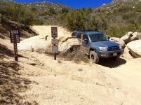
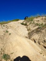
This is a just section of one the side trails and only half of the hill climb I would say more difficult most of the trail and one other with major ruts took many trys and restarts.


image.jpg
 

Attachments

  • image.jpg
    image.jpg
    135.4 KB · Views: 131
@Sentinel sorry if I messed your thread up just seemed a few questions about the trails needed to be answered and for anyone that maybe unsure about going or possible passengers they may questioned bringing along not knowing.
It is all family fun and great views as stated with a couple side bar runs to make things interesting or difficult as you want. plenty of good times will be had throughout the day I'm sure.
 
@Sentinel sorry if I messed your thread up just seemed a few questions about the trails needed to be answered and for anyone that maybe unsure about going or possible passengers they may questioned bringing along not knowing.
It is all family fun and great views as stated with a couple side bar runs to make things interesting or difficult as you want. plenty of good times will be had throughout the day I'm sure.

No biggie. Thanks for the input, its definitely appreciated.

So....I made a few phone calls to different stations, who couldn't answer my trail difficulty questions... until I was transferred to the Assistant Manager of the National Forest OHV program (Didn't ask if it was for all of the SB Nat'l Forest or just San Jac), Dave Bentley, who was very helpful and even wanted to come along. He is planning to be at the show spot to give us a quick brief on volunteer opportunities prior to heading out.

For reference, Dave gave the following report on the trails in our run area:

Blue Squares
5S15
6S13
5S07
5S09

Black Diamonds
4S21
4S06
4S10

I also promised him that we would be a responsible group and "police up" (military term for pick up) any trash that we found on the trail. I will bring trash bags with me so we can help keep the trail clean.
[MENTION=84642]Quatre Coureur[/MENTION], I put you up on the first post as a trail leader for the difficult run up Indian Mountain.

I mentioned if we can remain an active club, we may eventually be interested in adopting a trail, but that's way, way, down the road.

Note: I thought I did already, but for some reason the show time was still 9:30AM, that has been changed to an even 9AM. We'll plan on departing by 9:15AM, sorry if this causes any confusion.

 
Just FYI. The CORVA map for this area listed all but one of the trails as Green or 1 out of 3 with 3 being difficult / red.

So don't worry. You'll probably be fine bone stock.
 
Really looking forward to this trip. BTW has something happened to 4S21 since the last trail update? Washed away perhaps?

You mention it being a Black Diamond but in the link you provided, the guy who run it clearly says it is an easy blue.

These roads are all easy except for 4S21 Indian Mountain. Going downhill it is a mild blue, going uphill it is a difficult blue. It is very similiar to 2N17X, except much narrower. 4S21 starts on the high side at Hwy 243 at the Indian Vista N33.79700 W116.77794 and on the low side on 5S09 at N33.7676 W116.7894
 
Really looking forward to this trip. BTW has something happened to 4S21 since the last trail update? Washed away perhaps?

You mention it being a Black Diamond but in the link you provided, the guy who run it clearly says it is an easy blue.

Ya itll be fun with so many trucks on a route I always run solo. As far as 4s21( the whole mountain range for that matter) just dont get your hopes up on any challenging sections because there are none, unless snow is involved. Ive always liked going up there for the scenery more than anything
 

Members online

Forum statistics

Threads
278,316
Messages
3,554,124
Members
248,016
Latest member
Advally Service

Trending content

Back
Top