[MENTION=272937]jimmynotjim[/MENTION] and family joined my girls and me today for a little exploration along the Otay Mountain Truck Trail -- thanks for the good company! It was great to see the three kids hanging out on top of a boulder and chatting.
Some questions for the group wisdom:
- are there good side trails that a stock rig could do without risking damage? We kept exploring side roads, but most didn't go anywhere. We did mark one to come back to when the ground is a little more dry. But mostly we didn't find anything beyond the gravel road. Anyone have tracks or coordinates to share for side trails that we should try?
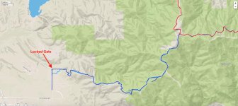
- at the south end, we came to a locked gate & would have been stuck except that a guy wearing a military uniform (but driving an unmarked pickup truck) came up after 5 minutes and had the key. Is there a way around if that gate is locked or do you have to drive all the way back to Pio Pico??
On the attached map, the dark blue was us today and the light blue is a shared GPX of the trail from the Interwebs. We were going to explore where the light blue is different than our trail for another way out, but then the guy with the key showed up. Anyone know if we would have found a way out??
Some questions for the group wisdom:
- are there good side trails that a stock rig could do without risking damage? We kept exploring side roads, but most didn't go anywhere. We did mark one to come back to when the ground is a little more dry. But mostly we didn't find anything beyond the gravel road. Anyone have tracks or coordinates to share for side trails that we should try?
- at the south end, we came to a locked gate & would have been stuck except that a guy wearing a military uniform (but driving an unmarked pickup truck) came up after 5 minutes and had the key. Is there a way around if that gate is locked or do you have to drive all the way back to Pio Pico??
On the attached map, the dark blue was us today and the light blue is a shared GPX of the trail from the Interwebs. We were going to explore where the light blue is different than our trail for another way out, but then the guy with the key showed up. Anyone know if we would have found a way out??