Sacramento Area Meet n Greet n Trail Run (Signal Peak) Sat. Sept. 2 2017

Rock Garden

Very interested... Although by the sounds of it.. I may need some armor asap...

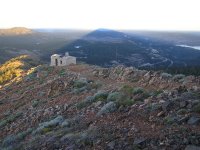
The Eagle Lakes side has some serious rock gardens. Big, jagged rocks that defeated my mostly stock '94 T4r. I revisited it a month ago in my new lifted 5th gen and decided it still wasn't worth the stress and possible damage.

By way of comparison, on the nearby Fordyce Trail, I've made it as far as the granite steps before the first creek crossing. The other side is a breeze; I've done it in my Manvan. For bonus points drive out to the old lookout (best done in the dark with liquid courage) and camp the night.

BTW: I live in Auburn, on I80, and am exploring the dirt roads at least once a week. I've done this for about 30 years in the area of Roseville to Reno, Placerville to Graeagle. Please feel free to contact me if you're in the area, and I can point you to some "known to locals only" kind of sites.

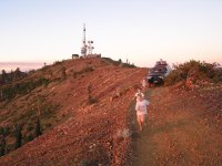
(edit) I had the kids get out and walk, in case my wife put the truck over the edge. Devil's Backbone kind of road.

 

Attachments

  • signal1.jpg
    signal1.jpg
    138.1 KB · Views: 98
  • signal2.jpg
    signal2.jpg
    138.4 KB · Views: 109
Last edited:
The Eagle Lakes side has some serious rock gardens. Big, jagged rocks that defeated my mostly stock '94 T4r. I revisited it a month ago in my new lifted 5th gen and decided it still wasn't worth the stress and possible damage.

By way of comparison, on the nearby Fordyce Trail, I've made it as far as the granite steps before the first creek crossing. The other side is a breeze; I've done it in my Manvan. For bonus points drive out to the old lookout (best done in the dark with liquid courage) and camp the night.

BTW: I live in Auburn, on I80, and am exploring the dirt roads at least once a week. I've done this for about 30 years in the area of Roseville to Reno, Placerville to Graeagle. Please feel free to contact me if you're in the area, and I can point you to some "known to locals only" kind of sites.

(edit) I had the kids get out and walk, in case my wife put the truck over the edge. Devil's Backbone kind of road.
I believe we took the Eagle Lakes side up and it was a nice rock garden. We didn't take the Fordyce trail, but I'm quite interested in going back up Signal Peak + Fordyce trail since I think I was having issues with my ATRAC that day.

I'd be interested in joining you on the dirt roads. I try to go wheeling every week or so too, if time permits. I'm guessing you explore the dirt roads closer to you?

I've been interested in some backroads/dirt roads directly north of Placerville. I forget what road I took since it was pretty dark out, but there was an OLD bridge not too far out. That's where I turned around since it was just too dark and wasn't sure if we could drive on it..
 
I believe we took the Eagle Lakes side up and it was a nice rock garden. We didn't take the Fordyce trail, but I'm quite interested in going back up Signal Peak + Fordyce trail since I think I was having issues with my ATRAC that day.


You are correct we did take the Eagle Lakes side UP there, and if I'm not mistaken, coming down THAT was Fordyce trail or Fordyce road. The super easy, mini-van-could-do-it-but-it's-dusty part.

Now this is where specifics matter. There's another trail called Fordyce CREEK trail I believe and that is supposed to be worse than the Rubicon. I also found there's another road called Eagle LAKE (no "S") Road way farther away near Lake Almanor. That's where my passenger that came with me thought we were going. Details matter!
 
You are correct we did take the Eagle Lakes side UP there, and if I'm not mistaken, coming down THAT was Fordyce trail or Fordyce road. The super easy, mini-van-could-do-it-but-it's-dusty part.

Now this is where specifics matter. There's another trail called Fordyce CREEK trail I believe and that is supposed to be worse than the Rubicon. I also found there's another road called Eagle LAKE (no "S") Road way farther away near Lake Almanor. That's where my passenger that came with me thought we were going. Details matter!


Oh, believe me, you do not want any part of Fordyce Trail. 5 winch hills with no bypasses, boulder fields, squeeze rocks, three river crossings. It was tough 15 years ago with 35's, crawler gears and lockers. It has on,y gotten worse. Makes the Rubicon look tame.
 
You are correct we did take the Eagle Lakes side UP there, and if I'm not mistaken, coming down THAT was Fordyce trail or Fordyce road. The super easy, mini-van-could-do-it-but-it's-dusty part.

Now this is where specifics matter. There's another trail called Fordyce CREEK trail I believe and that is supposed to be worse than the Rubicon. I also found there's another road called Eagle LAKE (no "S") Road way farther away near Lake Almanor. That's where my passenger that came with me thought we were going. Details matter!

This is good to know. For future reference. I'm assuming Fordyce Creek Trail was the one [MENTION=142877]Folsom4Rnr[/MENTION] was saying we could drive a bit into, when we were coming down from the tower?

Well.. I'm glad you guys pulled off at Eagle Lakes Road, instead of Eagle Lake road since you guys were quite behind us!!!
 
Well.. I'm glad you guys pulled off at Eagle Lakes Road, instead of Eagle Lake road since you guys were quite behind us!!!


Hey man! I told you guys I have a low top speed and then you all agreed and then blasted off hahah. I have the lowest gears at 4.88 man. 5th gear at 3,000 RPMs gets me to about 68 mph. Oh wait excuse me... 68 superchargered on premium fuel miles per hour haha. At least I beat [MENTION=80668]Loud Runner[/MENTION] considering his drive was double mine
 
Hey man! I told you guys I have a low top speed and then you all agreed and then blasted off hahah. I have the lowest gears at 4.88 man. 5th gear at 3,000 RPMs gets me to about 68 mph. Oh wait excuse me... 68 superchargered on premium fuel miles per hour haha. At least I beat [MENTION=80668]Loud Runner[/MENTION] considering his drive was double mine

I was just following Brian and his FJ bud.. and then I looked back and you were slowly loosing ground on us. haha And then that traffic made it worse..

Still not that bad. My WRX sat in 5th gear, at 3500rpm at ~65mph... that was just miserable. LOL
 
I believe we took the Eagle Lakes side up and it was a nice rock garden. We didn't take the Fordyce trail, but I'm quite interested in going back up Signal Peak + Fordyce trail since I think I was having issues with my ATRAC that day.

Yes, we took the Eagles Lake SIDE up to Signal Peak … we definitely did NOT do Fordyce.


You are correct we did take the Eagle Lakes side UP there, and if I'm not mistaken, coming down THAT was Fordyce trail or Fordyce road. The super easy, mini-van-could-do-it-but-it's-dusty part.

Now this is where specifics matter. There's another trail called Fordyce CREEK trail I believe and that is supposed to be worse than the Rubicon. I also found there's another road called Eagle LAKE (no "S") Road way farther away near Lake Almanor. That's where my passenger that came with me thought we were going. Details matter!

That was Fordyce Lake Road that we exited from. It goes out to Fordyce Lake... and it definitely is NOT the Fordyce trail folks talk about.


Oh, believe me, you do not want any part of Fordyce Trail. 5 winch hills with no bypasses, boulder fields, squeeze rocks, three river crossings. It was tough 15 years ago with 35's, crawler gears and lockers. It has on,y gotten worse. Makes the Rubicon look tame.

+1


This is good to know. For future reference. I'm assuming Fordyce Creek Trail was the one [MENTION=142877]Folsom4Rnr[/MENTION] was saying we could drive a bit into, when we were coming down from the tower?

I was talking about heading out to the lake (on the minivan-able road) not the trail of the similar name… confusing when they all have the same/similar names.
 
Hey man! I told you guys I have a low top speed and then you all agreed and then blasted off hahah. I have the lowest gears at 4.88 man. 5th gear at 3,000 RPMs gets me to about 68 mph. Oh wait excuse me... 68 superchargered on premium fuel miles per hour haha. At least I beat [MENTION=80668]Loud Runner[/MENTION] considering his drive was double mine

Sorry about that ... thought I was going slow enough.
 
Yes, we took the Eagles Lake SIDE up to Signal Peak … we definitely did NOT do Fordyce.

That was Fordyce Lake Road that we exited from. It goes out to Fordyce Lake... and it definitely is NOT the Fordyce trail folks talk about.

+1

I was talking about heading out to the lake (on the minivan-able road) not the trail of the similar name… confusing when they all have the same/similar names.

Thanks for the update. I'll remember these for future reference!


In any case, any plans to go wheeling before the winter season kicks in?
 
Thanks for the update. I'll remember these for future reference!

In any case, any plans to go wheeling before the winter season kicks in?


I know you weren't asking me necessarily, but in a few weeks I'm gonna check out this place more westernly and if I think it's worth it I can suggest it.

Cons: pretty long drive for the Sac Area folks

Pros: even in winter, there shouldnt be snow. Worst would be mud and dirt. And solitude.
 
I know you weren't asking me necessarily, but in a few weeks I'm gonna check out this place more westernly and if I think it's worth it I can suggest it.

Cons: pretty long drive for the Sac Area folks

Pros: even in winter, there shouldnt be snow. Worst would be mud and dirt. And solitude.

......how long is a "pretty long drive" from sac?

I'd be pretty interested, if it's not as bad as I interpret it to be.
 
......how long is a "pretty long drive" from sac?


I'd be pretty interested, if it's not as bad as I interpret it to be.


It's over by lake berryessa. Called Knoxville. It's actually an OHV park I believe. About 2 1/2 hours west from sac. My uncle and I are doing a quick night run since he's only in town and available for one night, and I'd invite everyone if he weren't such a weirdo...

That being said I can report back in a few weeks after we go. It's supposed to be pretty tame overall. And I don't know how the scenery is. But it's a place to go at some point if nothing else
 
Thanks for the update. I'll remember these for future reference!


In any case, any plans to go wheeling before the winter season kicks in?

Yeah, trying to figure something out for 10/21 or maybe 10/28 or maybe 11/4 ... was thinking of someplace like Plummer Ridge Trail or the like in the El Dorado National Forest.
 
It's over by lake berryessa. Called Knoxville. It's actually an OHV park I believe. About 2 1/2 hours west from sac. My uncle and I are doing a quick night run since he's only in town and available for one night, and I'd invite everyone if he weren't such a weirdo...

That being said I can report back in a few weeks after we go. It's supposed to be pretty tame overall. And I don't know how the scenery is. But it's a place to go at some point if nothing else

I will be interested in your report out... that place is on my short list to visit sooner rather than later.
 
I will be interested in your report out... that place is on my short list to visit sooner rather than later.


I'll certainly give you my take on it. We're heading out 10/22 (a Friday night, pretty late like 9 or 10pm.)

Video of the trail we wanna take. Called Knoxville devilhead road
https://youtu.be/Rrnv5lVrJJk

Seems really tame with a few spots to play in the mud if that's your thing.

And I think there are other trails that shoot off this particular one for more challenges. This one Just heads to a gate (private property) and then you turn around.

But the other ones might be cool for a day trip with a few people and eat lunch or whatever. And coolest part about the area is there's NEVER snow and doesn't flood much unless it's rained a LOT. So later in the year shouldn't be an issue either.
 
Last edited:

Members online

No members online now.

Forum statistics

Threads
278,315
Messages
3,554,131
Members
248,016
Latest member
Advally Service

Trending content

Back
Top