Trail Navigation (built in or phone)

visualfxengineer

New member
What are people using for trail runs? Is there something that uses your entune as I am struggling to find a use for that.

I have been using all trails as it seems to pick up all the fire roads and some trails. But it keeps having to be woken up.

Just looking for something simple that will show the trail we’re on and stays awake.

Thanks


Sent from my iPhone using Tapatalk
 
Register to hide this ad
Just looking for something simple that will show the trail we’re on and stays awake.

Sent from my iPhone using Tapatalk

Paper maps, never run out of batteries, signal, doesn’t go to sleep, and if you get stranded can be used to make a fire. :lmao:
 
...and they are way more fun to blame the navigator/passenger wonderfully lost where no one else happens to be ;): :)

gees is it even possible to get “lost” in 87.65% of the US anymore? Seems easier to get lost in town than out in the wild.

Like paper maps, compass, ruler and pencils... hell if I knew how to use a sextant :D
 
Last edited:
What are people using for trail runs? Is there something that uses your entune as I am struggling to find a use for that.

I have been using all trails as it seems to pick up all the fire roads and some trails. But it keeps having to be woken up.

Just looking for something simple that will show the trail we’re on and stays awake.

Thanks


Sent from my iPhone using Tapatalk

The sleep part is a phone setting.. you can turn that off.. i use leadnav gps and have california trail maps loaded on it... detailed maps without any cell service..
 
Side question, does anyone use the entune for anything? Anything it can do, wayz seems to do better.


Sent from my iPhone using Tapatalk
 
GPS in my phone died about 6 months ago, so haven't been using it lately, but used to use Back Country Navigator. It allows you to download topo maps for offline use and uses GPX files for tracks.
 
I've actually been surprised at the number of FS roads and trails in the factory nav, but I use Gaia GPS + paper maps

Side question, does anyone use the entune for anything? Anything it can do, wayz seems to do better.
i actually don't think it's that bad, i like it more than the infotainment on my volvo and more than any of the ford or chevy rentals i've had lately
 
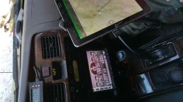
Been using this system with zero fails for the last 4 years. It has moved from my 5th Gen to my 3rd Gen.

20150607_144639.jpg

20160623_162527.jpg
 

Attachments

  • 20150607_144639.jpg
    20150607_144639.jpg
    125.3 KB · Views: 1,024
  • 20160623_162527.jpg
    20160623_162527.jpg
    129.4 KB · Views: 1,013
GPS in my phone died about 6 months ago, so haven't been using it lately, but used to use Back Country Navigator. It allows you to download topo maps for offline use and uses GPX files for tracks.

Pilot friend uses one of these:
https://bad-elf.com/products/be-gps-2200

BT to your phone/iPad/Android/tablet/whatever. Cheap, external, and accurate. lol I have had one sitting in my cart for almost two years...
 
Last edited:
Pfffft. I use my brain and eyes.

Got totally lost last weekend. So lost in fact that we didnt know we were lost until we asked a mountain biker where a POI was. We were so far off we just continued on knowing we were in So Cal and eventually the dirt would turn to pavement.

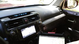
I turned on my nav and sure enough it had the name of the trails we were on and VERY details turns all mapped out.

Pretty cool to say, “I think we are here and if that is true we should come to a super tight right hand u turn in a mile or so.” And then come to that turn about a mile later.

So it was a fun adventure and the fact nav proved itself but for serious wheeling I like maps.
 
Entune is 100% useless and dumb, just another way for toyota to collect some of my personal info for who knows what.

Once I "activated" the app, I quickly reset the stereo first day. I'm good with youtube, podcasts and my thumb drive full of music. I don't see a need for entune since it uses my phone anyways.

But I wonder if the "premium" navigation can be used for anything off road or for trail navigation. I have tried a few times in the city and gave up when Wayz whooped it on all time estimates. I haven't tried it outside those tests.
 
I use Gaia GPS on an iPad, in addition to an external GPS receiver. It’s easier for me to use vs my phone.


XGPS160 | Dual Electronics


Gaia I looks pretty good. I’ll give it a try today.

Has anyone used the Funtreks app? Yeah horrible name. It’s made by the folks that made the off road books I keep in my console with the topos. I do love the books. But for $60 for the app, I want to see if anyone uses it. According to one review it is nothing like the books


Sent from my iPhone using Tapatalk
 

Members online

Forum statistics

Threads
278,312
Messages
3,554,086
Members
248,016
Latest member
Advally Service

Trending content

Back
Top