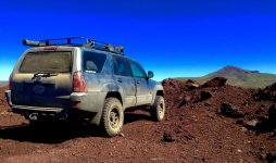
Post your Socal Adventure pictures

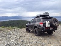
South Lake Tahoe,Genoa peak. Took my bro in law to this peak for the first time. He was amazed at the view. Now he wants to lift his fj80 land cruiser.
 

Attachments

  • image.jpg
    image.jpg
    137.7 KB · Views: 409
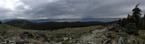
Panoramic view from Genoa peak. Some thunderstorms going on in the distance. Missed a few potential shots with lightning going on.
 

Attachments

  • image.jpg
    image.jpg
    144.6 KB · Views: 387
Went for a local trip out to beaumont area to do some shooting and hill fun.


found that the car that was abonadoned still out there, we called about a month ago and they never got it out so i had a little fun. people shot it all to shit.


tested my solar setup a bit to see how it works, seems to be all good.

 
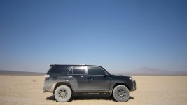
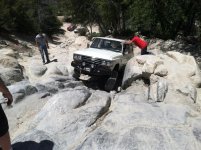
Dry Lake Bed and some climbing by Randsburg, Ca


sorry for the size
 

Attachments

  • IMG_4716.jpg
    IMG_4716.jpg
    140.4 KB · Views: 359
10th Annual Toy120 Mojave Preserve Trail Run 2015
Sept 18-21 Thanx to [MENTION=6237]my034runner[/MENTION] aka "Mr. Mojave" for making it possible and just
an absolute blast from finish to end. This being the view almost at the top of a volcano just below the lava tubes we went inside of. The real challenge was the road/trail or should I say what use to be the "road/trail" leading to the volcano and up to this view point was an accomplishment in itself, the last rain/storm we had completely washed it away leaving nothing but cracks and crevices which also exposed a bed of giant sharp volcanic rock that dirt use to once cover before, leaving very little and especially hard to make out what was the trail from landscape. Made for on the edge of your seat good times.

image.jpg
 

Attachments

  • image.jpg
    image.jpg
    139.8 KB · Views: 504
Last edited:
Went up to Garner Valley yesterday to explore a couple different areas which ended up being a bust.

I came across Gold Shot Mine off Pimlico Canyon during a googlemaps search. I found two routes, one via Hialeah Way and the other off Paradise Dr. Paradise was a dead end and Hialeah is on private property with a couple no trespassing signs. Not wanting to press my luck, we didn't continue on.

Next was Fobes Ranch Rd, which is gated a little over two miles in. For anyone curious target shooting is currently not allowed.

Last was Old Control Rd which is in great shape and easily done in 2WD. There's not much special about this road, but I could see driving it as part of a Bee Canyon/Old Control loop. Here's a pic of the view. DVL is in the center.

 
10th Annual Toy120 Mojave Preserve Trail Run 2015
Sept 18-21 Thanx to [MENTION=6237]my034runner[/MENTION] aka "Mr. Mojave" for making it possible and just
an absolute blast from finish to end. This being the view almost at the top of a volcano just below the lava tubes we went inside of. The real challenge was the road/trail or should I say what use to be the "road/trail" leading to the volcano and up to this view point was an accomplishment in itself, the last rain/storm we had completely washed it away leaving nothing but cracks and crevices which also exposed a bed of giant sharp volcanic rock that dirt use to once cover before, leaving very little and especially hard to make out what was the trail from landscape. Made for on the edge of your seat good times.

View attachment 173456


This looks awesome. Adding it to my must do list. I need to get over Toyota-120 sometime.
 
[MENTION=10950]Brian[/MENTION]SD42 Thank you and it was awesome doing it again in april with Robert my034Runner from Toy120 who leads it if your interested.

By the way, where are you planning on camping at the night before the october 17th meet and trail run
 
Trail: Bee Canyon to Indian Creek Truck Trail

I've take Bee Canyon to San Jacinto Ridge to Pine Cove several times, but have never made the turn at Indian Creek to head North. A friend of mine was itching to go out in his JK and had never been to the area, so I figured what better time to go than now.

The route is just under 13 miles, but because of trail conditions and several stops to let our kids explore the journey took 4hrs. High clearance and 4WD were needed to deal with washouts, slippery uphill conditions and a few inches of snow covered trail near the top.


The first part of Bee Canyon was definitely the worst. Several sections were washed out, the worst was the last which we decided to break out the shovels for. Not sure how effective we were, but we both were hanging wheels to get through.


Ruts were a pretty common site along the trail. Higher up on Indian Creek ruts would cross the road and it was generally pretty slick. I had to keep my moment going with stock tires and had to reverse a few times and give it another go.


Kids' stop #1 was at the intersection of Bee Canyon and Indian Creek. Great view and a mud puddle for the kids.


It wasn't long before we came to this washed out area. While we checked the route my oldest decided to practice his army crawl.


Kids' stop #2 was a turnout along Moller Creek. We did some rock scrambling down to a small water fall. Slick granite + adventurous kids = lots of yelling. The way the water had carved into the rock was pretty sweet.


I believe the snow covered peak is Black Mountain.


One of my favorite sections, it felt like we were on a hotwheels track.


Views were incredible for nearly the entire trip.


The edge of snow. Fortunately the road wasn't too torn up so navigating the trail wasn't anymore difficult, just a little slower.


Kids' stop #3. Fearing we'd leave the snow never to return, the kids kept wondering when we would stop. This area was relatively flat with a good mix of bush and tree for the kids to get lost in.


The trail was covered in snow for the last half mile. This lead to a lot of sliding at the turns, fortunately toward the mountain and not off the edge. Near the 243 we came across a couple families playing in the middle of the trail.


It was fitting we had to break out the shovels once again to get back on the highway. There was a giant mound of snow and dirt from the snowplow.


The sides of the highway were packed with cars any where they could fit. A newer Tacoma ran off the road just north of Pine Cove, luckily in a section with no people and no drop off. Idyllwild was packed so we decided to eat lunch at Mile High Cafe at the south end of town. Food was good, but service was slow. After that was kids' stop #4 at the park. Parking along the highway was craptastic so we parked in snow where we normally park when there's no snow.


Forum statistics

Threads
278,312
Messages
3,554,089
Members
248,016
Latest member
Advally Service

Trending content

Back
Top